
Happy Groundhog Day!
On this day when we turn to trusty rodents to determine our forecast, the results appear to be 50/50, if you count the Vancouver Island marmots.
Shubenacadie Sam saw his shadow this morning predicting an early spring. Wiarton Willie also predicts an early spring. Punxsutawney Phil predicts six more weeks of winter. Vancouver Island marmots (and local meteorologists) are bracing for another round of snow this weekend.
Clear today, gone tomorrow
Today is the last day of clear skies before snowy conditions blanket the island tomorrow. Today’s sunshine and cold temperatures can be attributed to an area of high pressure which has sent cold air funnelling out to the coast from the north east.
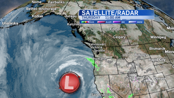
The high set up north of a low pressure system which has spent the last few days spinning off the California coast.
This blocking pattern prevents any eastward movement of systems, so essentially we’ve been stuck in the same cold clear weather for a number of days.
Today the blocking pattern is breaking down, which will allow the low to move northeast, first towards Washington State then sending its warm front north towards Vancouver Island.
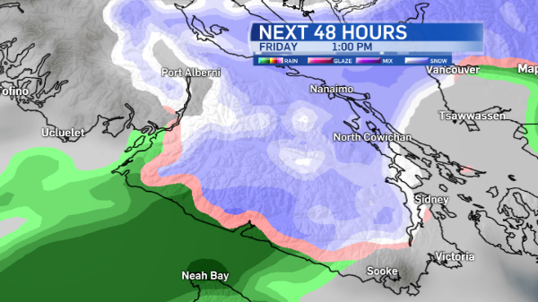
As that front approaches Friday morning snow is expected to fall on many parts of the south and mid-island as well as the Lower Mainland throughout the day. While the timing of this snow event can and will change slightly, here’s what I’m looking at right now for tomorrow.
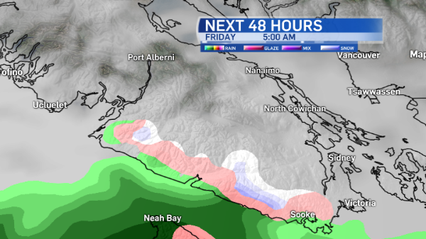
The shift in the weather pattern begins in the early hours of Friday morning. Clouds increase overnight and by 5 a.m. snow is expected to begin falling between Sooke and Port Renfrew.
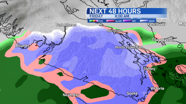
Give yourself extra time to drive to work. By 8 a.m. it looks like it’ll be snowing through the West Shore towards the Saanich Peninsula and the Malahat.
Nanaimo might be seeing some flakes, especially at higher elevations. Ucluelet will be on the edge of the rain/snow transition.
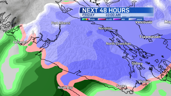
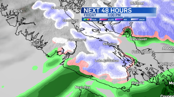
By 10 a.m. the warm front pushes precipitation as far north as Port Alberni.
Cold conditions in the Alberni Valley will prevent the snow from changing to rain. Tofino and Ucluelet, however, will be a bit too mild for more than a rain-snow mix. Expect mostly drizzle.
By early afternoon the Capital Region gets a bit of a break, while the snow falls on Vancouver.
At around 3 p.m. light rain is expected for coastal communities, including Greater Victoria, Sooke, Port Renfrew, Tofino and Ucluelet.
Nanaimo, Cowichan Valley and Port Alberni will still have some snow. The Courtenay-Comox area as well as Campbell River will see some afternoon flurries too.
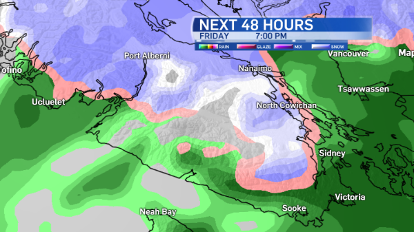
The evening will see some more snow for inland island communities and spots on the east coast as another low approaches the area.
Forecast models suggest the south island will get more in the way of rain.
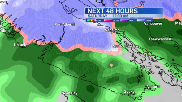
As milder Pacific air is ushered in, the precipitation gradually changes from snow to rain, so expect a rain-snow mix for Saturday.
Another system approaches Sunday, which will also bring snow or a rain-snow mix to the island.
How much snow will fall?
That’s a tricky question to answer. There are many factors including, but not limited to, elevation, proximity to the water and temperature. Vancouver island has so many microclimates!
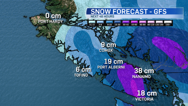
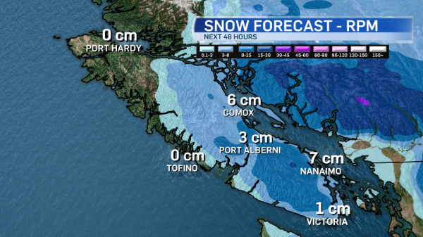
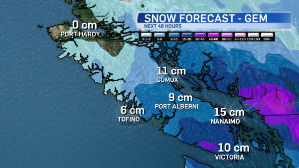
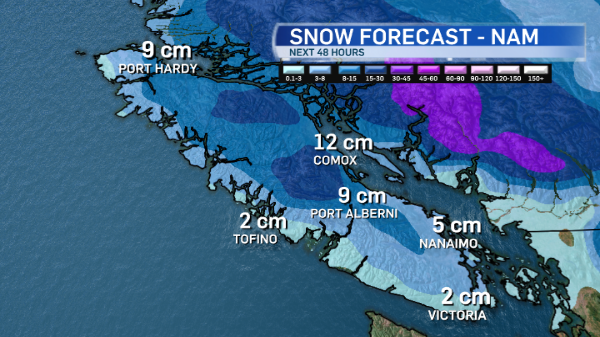
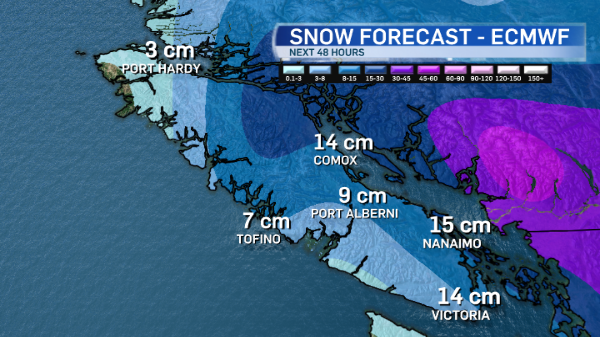
Here’s a look at the snow accumulation predictions from five forecast models I regularly look at when putting together your forecast: The US GFS, the US RPM, the Canadian GEM, the US NAM and the European ECMWF.
You can see how there’s quite a range in expected snowfall accumulation in the next 48 hours, up to 10 a.m. Saturday.
I’ll have my full forecast for you tonight on CTV News at 5 and 6. See you then!


