Vancouver Island could see snow next week
 (CTV News)
We continue to make up for our "dry time" with another storm moving across Vancouver Island on Thursday and Friday. Storm season has arrived so let's prepare for another shot of rain and strong winds.
In a given year, Vancouver Island can have anywhere between roughly 12 to 25 atmospheric rivers. Some are bigger and more intense than others.
So far we've seen typical autumn storms which is a nice way to slowly build the moisture totals back to normal without having major negative impacts.
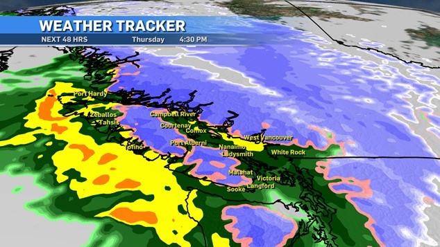
Thursday will see another storm hit the island, this a stereotypical Pineapple Express having developed near the Hawaiian Islands and moving east. Along with the rain, which for Greater Victoria should start around noon, we'll see a temperature bump for Friday.
Rain will continue through the day Friday and move out late that night or during the overnight period into Saturday.
Special weather statements have been issued by Environment Canada and we could see a few rainfall warnings in some island areas this week.
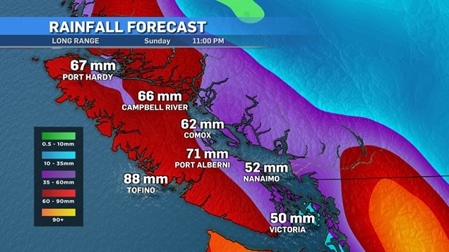
We can expect pretty consistent totals across Vancouver Island with most regions being in the 30 to 50 millimetre range, with certain areas possibly closing in on 70 millimetres.
 (CTV News)
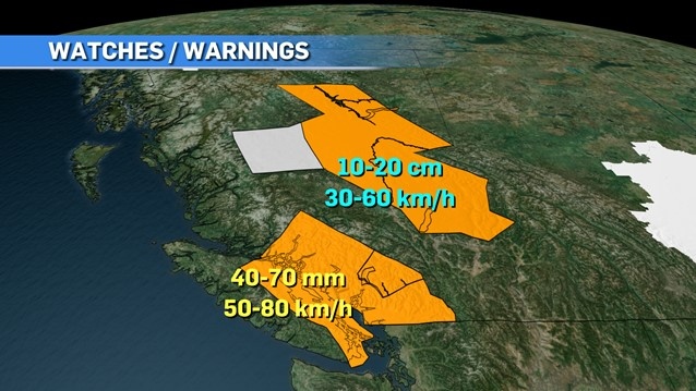
Wind will also be a factor gusting in the 40 to 60 km/h range for southern spots. Along the eastern coast and along the straits those gust could touch the 80s.
 (CTV News)
Another part of this weather recipe will be some colder Arctic air seeping into the province.
While I'm not too concerned about snow on Vancouver Island over the next couple of days, higher elevations inland will see some.
 (CTV News)
The mainland, especially the Sunshine Coast and mountain ranges, could see a nice blanket with 10 to 20 centimetres possible in some areas.
Once this atmospheric river passes we do see that cold air mass plunk itself down in Western Canada which will give us much colder temperatures and high odds of snow.
Here on the island I'm keeping a keen eye on mid-next week, where another round of rain and cold temperatures could result in a good chance of some sticky snow being produced in many areas.
It's early and things will change but it's on the table. After a quiet September and October we're making a lot of weather noise within the last couple of weeks.
CTVNews.ca Top Stories

Massive high-tech Canadian helicopter helps navy in hunt for submarines
Canadian warships on a mission to promote peace in the hotly-contested waters of the Indo-Pacific includes a highly-skilled specialized crew from the Royal Canadian Air Force.
Ontario pitches energy partnership with U.S. amid Trump's tariff, Canada annexation threat
In the face of incoming U.S. president Donald Trump’s threat to acquire Canada and impose tariffs, Ontario Premier Doug Ford says he wants to expand its energy supply both sides of the border.
Mexico's president offers sarcastic retort to Trump's 'Gulf of America' comment
Mexico's President Claudia Sheinbaum responded sarcastically on Wednesday to U.S. president-elect Donald Trump's proposal to change the name of the Gulf of Mexico to the Gulf of America.
LIVE UPDATES Tracking the L.A. wildfires: 2 dead as major fires at 0% containment, locals describe 'terrifying' escape
A series of wildfires are searing through the Los Angeles area, forcing many to evacuate their homes. Follow along here for the latest updates.
Calgary Flames game postponed in L.A. as wildfires burn nearby
The Calgary Flames game in Los Angeles on Wednesday night has been postponed due to the wildfires raging through the area.
Canada among 'top 5 losers' in new passport ranking
A new global ranking may raise doubts about Canada's reputation of being open to other countries.
JetBlue passenger suddenly opens exit door as flight is taxiing for takeoff at Boston airport
A person on board a plane at Boston Logan International Airport that was taxiing for takeoff suddenly opened an exit door and was quickly restrained by other passengers, authorities said.
Ricki's and cleo retail brands closing, Bootlegger restructuring
Several Canadian fashion retailers will be closing their doors after ownership company Comark Holdings announced it has filed for creditor protection.
Newborn babies at a Virginia hospital have been suffering mysterious injuries. A nurse now faces abuse charges
Parents may now be closer to understanding what happened at the hospital, which has reported a series of mysterious injuries to newborns over the past several years.


