Here's what to expect with this weekend's snowstorm
Is it spring yet? No, no it’s not. It’s another round of winter this weekend with snow and cold.
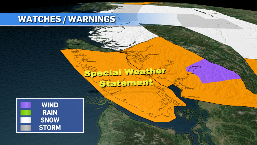
Special weather statements blanket most of Vancouver Island as we prepare for another dump of snow Saturday. Like with any snow event on the island, the amount of snow will vary through many areas and with this particular system there’s a lot of variability due to those strong Arctic outflow winds.
We have ranges for snow totals, with inland and eastern Vancouver Island getting 10 to 20 centimetres and Greater Victoria along with the west coast in the five- to 15-centimetre range. High snowfall amounts are possible over upslope regions and higher terrain.
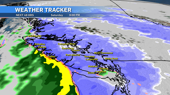
This system will move onto the island early Saturday morning, in the overnight period, starting in the north and west and spreading southeast through the day.
In the Greater Victoria area and possibly the southern Gulf Islands during the evening hours, some of that snow will change over into rain with a little pocket of warm air moving through the area.
From what I’m seeing, the hardest hit areas look to be some parts of the west coast, inland areas and east Vancouver Island, especially in the Comox Valley.
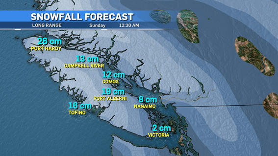
When we forecast these storms and systems, we use a variety of models and most times they are very close in agreement but with a dynamic system such as this one, even the models can’t agree with who is getting how much.
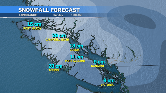
As you can see in the forecast pictures, there are different numbers in several areas.
The model on the top is the Global Forecast System model, which is run by the U.S. National Weather Service. This model is very accurate overall when it comes to forecasting on the island.
The other model is from the European Centre for Medium Range Weather Forecasts (ECMWF), an independent intergovernmental organization supported by many organizations.
Again, these are just predictions based on the data. During the system, things change and the environment can change fast, leading to more snow or less snow.
Either way it’s another winter storm to deal with before we get to spring, which will be here… eventually.


CTVNews.ca Top Stories

Death toll from Hurricane Helene rises to 227 as grim task of recovering bodies continues
The death toll from Hurricane Helene inched up to 227 on Saturday as the grim task of recovering bodies continued more than a week after the monster storm ravaged the Southeast and killed people in six states.
Car flies into B.C. backyard, lands upside down
A driver suffered only minor injuries after going airborne in a residential neighbourhood in Maple Ridge, B.C., on Friday, the car eventually landing on its roof in someone’s backyard.
Donald Trump, Elon Musk attend rally at same Pennsylvania grounds where gunman tried to assassinate Trump
Donald Trump returned on Saturday to the Pennsylvania fairgrounds where he was nearly assassinated in July, holding a sprawling rally with thousands of supporters in a critical swing state Trump hopes to return to his column in November's election.
Tax rebate: Canadians with low to modest incomes to receive payment
Canadians who are eligible for a GST/HST tax credit can expect their final payment of the year on Friday.
'No one has $70,000 dollars lying around': Toronto condo owners facing massive special assessment
The owners of a North York condominium say they are facing a $70,000 special assessment to fix their building's parking garage. '$70,000 is a lot of money. It makes me very nervous and stressed out of nowhere for this huge debt to come in,' said Ligeng Guo.
Police ID mom, daughter killed in Old Montreal; video shows person break into building before fatal fire
Police released the identities of the mother and daughter who were killed after a fire tore through a 160-year-old building in Old Montreal on Friday.
Frequent drinking of fizzy beverages and fruit juice are linked to an increased risk of stroke: research
New data raises questions about the drinks people consume and the potential risks associated with them, according to researchers at Galway University in Ireland, in partnership with Hamilton’s McMaster University.
'I screamed in shock and horror': Family faces deadly Vancouver hit-and-run driver during sentencing
The sentencing of the man who pleaded guilty in the deadly hit-and-run in Kitsilano two years ago began on Friday.
Vanderbilt takes down AP poll No. 1 Alabama 40-35 in one of college football's greatest upsets
Vanderbilt takes down AP poll No. 1 Alabama 40-35 in historic college football victory.
Shopping Trends
The Shopping Trends team is independent of the journalists at CTV News. We may earn a commission when you use our links to shop. Read about us.


Vancouver
-

Witnesses say one dead after pickup truck plows through bus stop in Surrey
One person is reportedly dead and two others are injured after a pickup truck hit a bench, striking people who were waiting for the bus in Surrey Saturday afternoon.
-
Massive fire destroys downtown Langley restaurant
A massive fire broke out in downtown Langley Saturday morning, destroying a restaurant and forcing several other businesses to close.
-
Son charged with mother's murder on Vancouver Island
Police on Vancouver Island have made an arrest in the case of a 78-year-old woman found dead in her home almost two years ago.
Kelowna
-

2nd-degree murder charge laid nearly 2 years after Kelowna stabbing
Nearly two years after a man was stabbed to death in downtown Kelowna, RCMP have made an arrest in the case.
-
Eby promises $75 million rural health loan forgiveness plan at Okanagan campaign stop
NDP Leader David Eby is promising to offer a $75-million loan forgiveness program to entice doctors, nurses and heath professionals to expand health-care services in rural British Columbia.
-
Several 'aggressors' arrested after B.C. teen swarmed, B.C. RCMP say
Three young suspects have been arrested in connection with a swarming attack on a teenager in B.C.'s Okanagan last week – and authorities have asked the public to stop circulating disturbing videos of the incident.
Edmonton
-

Crash between motorcycle and van closes Highway 39 near Warburg
Highway 39 near Warburg was closed Saturday after a serious crash involving a motorcycle and a van.
-
'We're losing billions of birds': Backyard risks to Alberta's birds and how you can help make fall migration a successful one
An estimated four billion birds will navigate man-made environments as they travel south from North America during fall migration. Tens of million of them will die en route due to human-created hazards.
-
'They make me dig deep': 63-year-old CFR champion looks for 2nd win in Saturday finals
Barrel racer pro Lynette Brodoway has been riding in rodeos since before some of her competitors were born.
Calgary
-

Serious crash impacts traffic on northbound Deerfoot Trail
Emergency crews are on scene of a multi-vehicle collision along northbound Deerfoot Trail near 17 Avenue Southeast.
-
Pro-Palestinian rally at Calgary City Hall ahead of first anniversary of October 7 Hamas attack on Israel
The first anniversary of the October Seventh Hamas attack on Israel is Monday and that prompted several hundred people to attend a pro-Palestinian rally Saturday afternoon at city hall.
-
Investigation underway into Friday night fatal collision in southeast Calgary
An investigation is underway into a Friday night collision in southeast Calgary that left one person dead.
Lethbridge
-

Slow down! Lethbridge County pleads with motorists in construction zones
While the summer may be over, construction season in Lethbridge is not.
-
Lethbridge police seize fentanyl, weapons, stolen vehicle in downtown enforcement project
Lethbridge police executed dozens of warrants and laid numerous charges in another targeted enforcement project in the downtown area.
-
Driver airlifted following serious crash in Taber, Alta.
A person was airlifted to hospital following a serious crash in Taber, Alta., on Friday morning. Taber RCMP responded to the scene on Highway 864 around 10:30 a.m., for a crash involving an SUV and a semi-truck.
Winnipeg
-

'Great fun in this': Giant roadside attractions across Manitoba highlighted online
It’s 1998. Google was just born, and dial-up was the primary way to connect to the Internet. New sites were being developed daily on any number of topics, from recipes to shopping. David Yanciw, however, was thinking big - big things, that is.
-
Homelessness on the rise as encampments spread to Steinbach
Communities outside of the perimeter aren’t immune to the housing and affordability struggles seen in Winnipeg.
-
Seniors' advocates warn of 'severe consequences' ahead of likely worker strike
As many as 25,000 employees could hit the picket lines as early as Tuesday morning, making it the second-largest strike in Manitoba’s history.
Regina
-

Roughriders edge Elks 28-24, clinch playoff berth
The Saskatchewan Roughriders have clinched a playoff spot thanks to a win over the Edmonton Elks.
-
Sask. Party, NDP make weekend campaign stops in Moose Jaw with promises to invest in the city
Saskatchewan's two major political parties made campaign stops in Moose Jaw Saturday with both promising to invest into the city if elected on Oct. 28.
-
Wind gusts around 100 km/h hammer Regina, southern Sask.
A wind warning was issued for parts of southern Saskatchewan, with gusts of up to 100 kilometres per hour (km/h) possible in some areas on Saturday, Environment and Climate Change Canada says.
Saskatoon
-
Roughriders edge Elks 28-24, clinch playoff berth
The Saskatchewan Roughriders have clinched a playoff spot thanks to a win over the Edmonton Elks.
-
Private school funding draws attention during STF education forum
The Saskatchewan Teachers' Federation hosted a virtual election forum on education Thursday evening, giving candidates in the provincial election a chance to share their thoughts and answer questions on issues teachers find most important.
-
Sask. community marks sod-turning for Humboldt Broncos memorial
A permanent memorial at the site of the 2018 Humboldt Broncos bus crash is about to be a step closer.
Toronto
-

Ontario Science Centre to open up temporary satellite locations months after sudden shutdown
The Ontario Science Centre is set to launch two temporary satellite locations in other parts of Toronto, which could let visitors access some of its interactive exhibits while a full interim location remains at least a year away, CTV News has learned.
-
Fans cheer Messi as Toronto FC concedes late goal to Miami and misses out on playoffs
Leo Campana's stoppage-time goal gave Inter Miami a 1-0 win and left Toronto FC's playoff hopes hanging by a thread Saturday.
-
Officer arrested after allegedly stealing alcohol from store: TPS
A Toronto police officer has been arrested after allegedly stealing three bottles of alcohol from a store.
Montreal
-

Police ID mom, daughter killed in Old Montreal; video shows person break into building before fatal fire
Police released the identities of the mother and daughter who were killed after a fire tore through a 160-year-old building in Old Montreal on Friday.
-
Police boosting presence in Montreal ahead of Oct. 7 anniversary of Israel-Hamas war
Montreal police say they are increasing their presence across the city ahead of the one-year anniversary of the Oct. 7 start of the Israel-Hamas war.
-
Montreal business hit with Molotov cocktail 2 nights in a row: police
Montreal police say a business in the city's Pointe-Saint-Charles neighbourhood was hit with Molotov cocktails two nights in a row.
Ottawa
-

Pro-Palestinian march held in Ottawa amid global day of protests
Demonstrators converged on downtown Ottawa Saturday afternoon as part of a global day of action to protest Israel's military actions in the Middle East.
-
Three injured, including child, in rural south Ottawa crash
Three people were taken to hospital after a crash between a pickup truck and a car in a rural part of Ottawa's south end on Saturday afternoon.
-
Frost advisory issued with temperatures expected to drop near freezing in Ottawa
Environment Canada has issued a frost advisory as temperatures across Ottawa and eastern Ontario are expected to dip near the freezing mark this evening.
Atlantic
-

‘Did I get a touchdown?’ Girls lead the way with 'powerpuff play' during football game in Moncton, N.B.
Avry Wortman, 13, scored two touchdowns on Sunday during her team's win in the under 14 Greater Moncton Football Association.
-
Battle between activist candidate and ex-Tory reflects schism in N.B. politics
A riding in southwest New Brunswick that for decades was a Progressive Conservative stronghold is shaping up to be a bellwether that could offer a window into the future of the Tory party, and maybe of the province.
-
Tropical Storm Milton forms in Gulf of Mexico, could intensify as a hurricane threatening Florida
Tropical Storm Milton has formed in the Gulf of Mexico. It is located 220 miles (355 kilometres) north-northeast of Veracruz, Mexico.
London
-

'We've got to get them home'; Organization continues search for missing London Ont. women
An organization who has assisted in locating 40 missing people since 2018, has its sights set on the Thames River near Cavendish Park in London, Ont.
-
One injured in plane crash near Brussels
Huron OPP say they were on the scene of a plane crash this morning, with a pilot finding themselves unable to halt before the end of a runway in Brussels.
-
Tax rebate: Canadians with low to modest incomes to receive payment
Canadians who are eligible for a GST/HST tax credit can expect their final payment of the year on Friday.
Kitchener
-

One injured after small plane crash lands in Brussels
The Huron Ontario Provincial Police said they responded to a “downed airplane” just after 11 a.m. Saturday.
-
One person sprayed with 'noxious substance' in Cambridge
Police say they were called to the area of Simcoe Street and Market Street around 1:30 a.m. Saturday for a report of an assault.
-
Urgent call for volunteers for Oktoberfest parade
The Oktoberfest Parade is fast approaching and organizers are urgently seeking volunteers to fill the role of sign carriers.
Northern Ontario
-

Canadian musician Jacob Hoggard found not guilty of sexual assault
Canadian musician Jacob Hoggard has been found not guilty of sexually assaulting a young woman in northeastern Ontario eight years ago. The former Hedley frontman had pleaded not guilty to sexual assault.
-
Police ID mom, daughter killed in Old Montreal; video shows person break into building before fatal fire
Police released the identities of the mother and daughter who were killed after a fire tore through a 160-year-old building in Old Montreal on Friday.
-
No injuries reporter in Greater Sudbury garage fire
Fire crews in Greater Sudbury battled a large garage fire on Friday.
N.L.
-

Marathon goat: Animal runner wins hearts and a medal after crashing Newfoundland race
He may not have logged the fastest time or even gone the full distance, but residents of a Newfoundland town agree the goat who unexpectedly joined the local weekend half marathon was the event's undisputed champion.
-
Labrador residents say 'inhumane' food prices force families to go hungry
A mother in a community where the cost of living is one of the highest in the country says grocery prices are 'inhumane' and retailers are putting profits ahead of people’s basic human right to food.
-
Small English soccer team has huge year, thanks in part to Newfoundland and Labrador
A soccer game in England on Tuesday night drove a spike in online traffic across the Atlantic to a website launched by the Newfoundland and Labrador government.