
Today’s intense storm featuring remnants of Typhoon Songda is approaching.
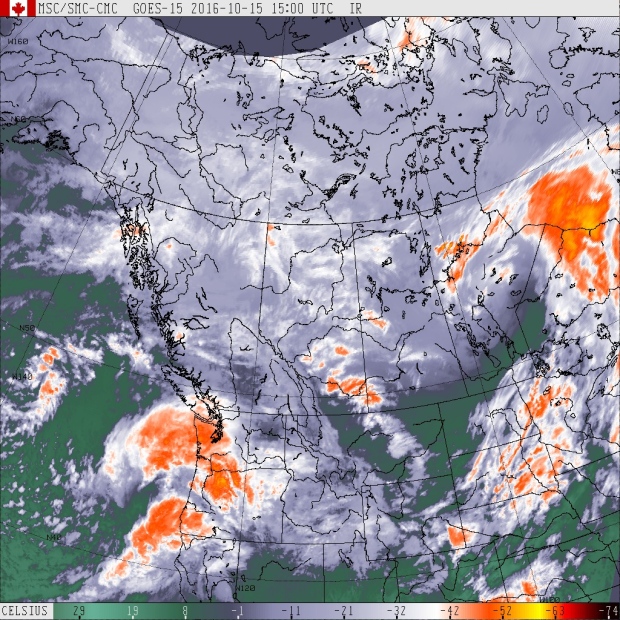
Satellite image produce by Meteorological Service of Canada (MSC)
Here’s the timeline for Vancouver Island:
3-5 p.m. Rain really starts to increase over southern Vancouver Island
8-9 p.m. Centre of storm makes landfall near Ucluelet, crosses NE towards Port Alberni
11 p.m. Centre of residual low crosses into the lower mainland
12 a.m. - 2 a.m. Winds begin to diminish
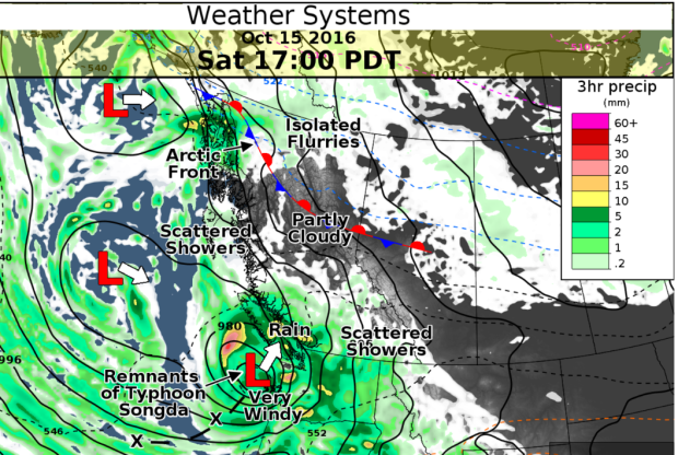
graphic produced by the Meteorological Service of Canada (MSC)
Winds will be strongest to the southeast of the storm track.
Southeasterly winds are expected to reach 100km/h over land, 120km/h over water. To put this in perspective, 120km/h winds is hurricane force.
In the bullseye are south Vancouver Island, Vancouver, Howe Sound, southern strait of Georgia and parts of the Fraser Valley.
Wind warnings have been issued for:
- Greater Victoria
- Southern Gulf Islands
- East Vancouver Island
- Sunshine Coast
- Howe Sound
- Metro Vancouver
- Fraser Valley
This morning, the National Weather Service in Seattle had a report from a ship just west of the low centre near 43N 132W. It reported sustained winds of 45 knots. That’s 52 mph, or approximately 85km/h. And the storm is still strengthening.
The good news: this storm is fast moving so winds will begin to diminish after midnight.
Here comes the rain
In addition to winds, the tropical moisture within this storm will bring bands of heavy rain to the area tonight and tomorrow morning. In some cases, areas will receive 50-100mm rain before the end of the weekend. The highest amounts are expected through southern and central Vancouver Island.
Rainfall warnings have been issued for:
- East Vancouver Island
- Metro Vancouver
- Howe Sound
Flood Risks
An extreme wave hazard advisory has been issued by Parks Canada.
If you are storm watching on the west coast, use extra caution on the beaches through Monday, nine metre swells are predicted. Adding to the hazards are very high tides which occur mid-morning to mid-afternoon. This is a recipe for flooded beaches, large waves breaking high on shore and dangerous surf conditions.
The BC River Forecast Centre has a high stream flow advisory in effect for parts of Vancouver Island, including:
- South Vancouver Island including the Englishman River, Chemainus River, Cowichan River and surrounding creeks and tributaries
- Central Vancouver Island including the Tsolum River, Browns River, Sproat River, Somass River and surrounding creeks and tributaries
http://bcrfc.env.gov.bc.ca/warnings/advisories/flood06.htm
There is a moderate risk of flooding around Campbell River and surrounding Coastal areas due to storm surge.
http://www.stormsurgebc.ca/files/bulletins/campbellr.png
Post-storm Sunday
Following the storm, the air mass will be unstable. There’s a chance we’ll get some thunderstorms along with showery conditions Sunday.
Be Prepared
This is a powerful, dangerous wind storm. Be prepared for power outages, downed trees and pooling water, even flooding. Charge up your phones and laptops! Make sure loose objects outside are either tied down or put away.
Be safe!


