A ridge of high pressure dominates our weather pattern this week. Sunshine is back on the island, a welcome change after what seemed like a never-ending month of rain. Fog is likely at times this week, especially in valleys and low lying areas.
At higher elevations skies will be clear and conditions mild in the mountains as a temperature inversion sets up. Depending on where you are on the island, the clear skies will send overnight lows below freezing, but the overall outlook is for mainly sunny, dry weather for at least a week.
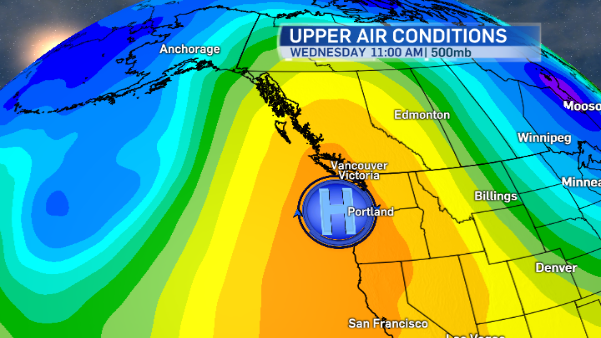
Blocking Ridge
The ridge of high pressure not only brings drier weather, but it blocks storms from reaching Vancouver Island. Fronts developing offshore will be deflected to the north which means rainy, windy weather will affect the extreme northeastern part of our province, along with Alaska and the Yukon.
Forecasting Fog
Forecasting the extent and duration of the fog will be the tricky parts this week. Fog will develop in the evenings and overnight in many areas, lingering the morning. But how long will it hang around? As the ridge intensifies throughout the week, moisture will remain trapped at the surface taking longer to clear. Winds are expected to be light and pressure gradients weak. If they pick up, the fog will mix out and clear more quickly.
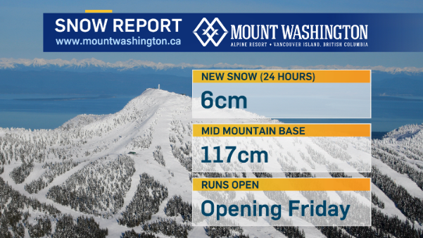
Freezing levels
Forecasts call for freezing levels to rise this week. That is not the best news for ski resorts, including Mount Washington, which could see temperatures peak around 10°C mid-week. The warmest day in the mountains looks like it’ll be Wednesday as freezing levels rise to 2400-2800 metres (possibly higher) in the afternoon. Conditions cool down a bit in time for the resort to fully open on the weekend.
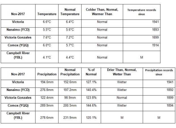
A look back at November
Based on statistics provided by Environment and Climate Change Canada, November definitely saw more rain than average on the island, while temperatures remained close to normal.