What's in store for summer weather on Vancouver Island?
 The Victoria Inner Harbor is pictured: (CTV News)
The arrival of June brings on the start of summer. So what can we expect for summer 2023? We’ll get to that in a minute.
First, let’s look back to spring, and more specifically the month of May. While it felt at times we were still stuck in winter mode, the month we just left broke that feeling in a big way.
March and April were pretty normal for the most part, although we didn’t get as much moisture as we would’ve liked. As we ended our third year with La Nina, the weather pattern held much of the big moisture to the south and gave heavy rain and bigger snow packs to California and Nevada. Here in the Pacific Northwest, we received what was left, meaning less moisture.
There were little bumps in temperature during the spring also. We had a record-setting weekend in the middle of March and we were able to determine that this year an El Nino would be building into the summer.
April was mostly typical, but as we started getting into the month of May we started seeing warmer temperatures – not just here on Vancouver Island, but across Western Canada and into parts of Ontario and Quebec.
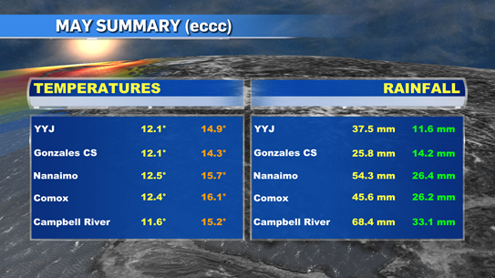
Now that May has come and gone, we can see what it did deliver weather wise. Here on the island we had the warmest May recorded. Two weather stations in Greater Victoria – the airport and Gonzales – along with stations in Nanaimo, Comox and Campbell River were all number one for heat since they started tracking data. Our mean temperatures were 2 to 4 degrees warmer throughout much of the province and with that we saw 279 extreme daytime highs and 22 precipitation records during May.
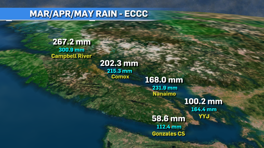
If you look at the precipitation numbers from meteorological spring (March/April/May), we can see we are lagging behind and the farther south you go, the bigger the lag is. With lower moisture numbers, we’re already preparing for a very dry summer.
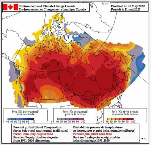
As we look ahead to summer, we have already established that it’s an El Nino year and it will get stronger the deeper as we get into the year.
We’re seeing both the Pacific and Atlantic oceans warming up at a faster pace than normal and numbers seem to be approx. 1-3 degrees warmer on average.
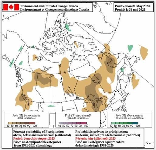
We're expecting a hotter than average summer throughout B.C. and rain seems to be lacking also.
That’s not saying we’re going to see weeks and weeks of temperatures in the 30s and 40s but it will be warmer and drier than usual and at a few points we’ll deal with heat waves and probable drought conditions through many areas.
It’s important we pay attention to the dry conditions as the risk of wildfires will be high this year. We’ve already been dealing with bad situations throughout the country.
Best case scenario is we get a run of sunshine and warm days followed by some moisture to keep things fresh. And just like your summer song this year, hopefully it stays on repeat. Of course, we know that weather doesn’t do what we want. It does what it wants and we just have to deal with it the best we can.


CTVNews.ca Top Stories

Spectacular aurora light show to be seen across Canada Friday night
A rare and severe solar storm is expected to bring spectacular displays of the northern lights, also known as aurora borealis, across much of Canada and parts of the United States on Friday night.
Which Canadian cities have the highest and lowest grocery prices?
Where you live plays a big factor in what you pay at the grocery store. And while it's no secret the same item may have a different price depending on the store, city or province, we wanted to see just how big the differences are, and why.
McGill University seeks emergency injunction to dismantle pro-Palestinian encampment
McGill University has filed a request for an injunction to have the pro-Palestinian encampment removed from its campus.
Swarm of 20,000 bees gather around woman’s car west of Toronto
A swarm of roughly 20,000 bees gathered around a woman’s car in the parking lot of Burlington Centre.
U.S. says Israel's use of U.S. arms likely violated international law, but evidence is incomplete
The Biden administration said Friday that Israel's use of U.S.-provided weapons in Gaza likely violated international humanitarian law but wartime conditions prevented U.S. officials from determining that for certain in specific airstrikes.
Barron Trump declines to serve as an RNC delegate
Former U.S. President Donald Trump's youngest son, Barron Trump, has declined to serve as a delegate at this summer’s Republican National Convention, according to a senior Trump campaign adviser and a statement from Melania Trump's office.
Mother assaulted by stranger while breastfeeding baby in her car: Vancouver police
A person was arrested in East Vancouver Thursday after allegedly entering a car while a mother was breastfeeding her four-month-old boy.
'We have laws': Premier Smith says police action justified in Calgary
The actions, including the decision to use non-lethal force, to disperse pro-Palestinian protesters from the University of Calgary campus were justified, Alberta Premier Danielle Smith said Friday.
'State or state-sponsored actor' believed to be behind B.C. government hacks
The head of British Columbia’s civil service has revealed that a “state or state-sponsored actor” is behind multiple cyber-security incidents against provincial government networks.
Shopping Trends
The Shopping Trends team is independent of the journalists at CTV News. We may earn a commission when you use our links to shop. Read about us.


Vancouver
-

'State or state-sponsored actor' believed to be behind B.C. government hacks
The head of British Columbia’s civil service has revealed that a “state or state-sponsored actor” is behind multiple cyber-security incidents against provincial government networks.
-
Suspect fled in 2-door Fiat after convenience store robbery, Merritt RCMP say
A suspect is at large after robbing a convenience store at gunpoint in Merritt, B.C., Friday, according to local police.
-
B.C. finance minister says she will retire following provincial election this fall
British Columbia's finance minister says she won't be running again in the next provincial election after serving in the legislature for nearly two decades.
Kelowna
-

Suspect fled in 2-door Fiat after convenience store robbery, Merritt RCMP say
A suspect is at large after robbing a convenience store at gunpoint in Merritt, B.C., Friday, according to local police.
-
Kamloops RCMP issue public warning about 2 men allegedly at centre of 'organized crime conflict'
After four targeted shootings in four days, Mounties in Kamloops are taking the unusual step of warning the public about two men they believe are likely to be targeted in future violent incidents.
-
Community mourns thousands of fish lost as B.C. drought risk looms again
Images of steelhead and trout flicker over long sheets of paper, brought to life in blue and green crayon rubbings by the thousands.
Edmonton
-
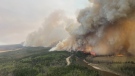
Out-of-control wildfire near Fort McMurray doubles in size Friday
The wildfire burning 25 kilometres southwest of the northeastern Alberta city doubled in size from 25 hectares at 9 a.m. to 50 hectares by 4 p.m.
-
Oilers star Leon Draisaitl questionable for Game 2 vs. Canucks
Edmonton Oilers star Leon Draisaitl is questionable for today's Game 2 against the Vancouver Canucks.
-
'Violent, despicable and unbelievable': Family of murdered 7-year-old speak at David Moss sentencing Friday
David Moss, the man who murdered seven-year-old Bella Rose Desrosiers, broke down in court Friday as the girl's family spoke about the toll her death has taken on them.
Calgary
-

'We have laws': Premier Smith says police action justified in Calgary
The actions, including the decision to use non-lethal force, to disperse pro-Palestinian protesters from the University of Calgary campus were justified, Alberta Premier Danielle Smith said Friday.
-
City of Chestermere inspection reveals ‘irregular, improper and improvident’ financial management: province
A third-party examination of the City of Chestermere revealed “significant gaps” in the financial management, the province said Friday.
-
Documents suggest Alberta's renewable-energy pause not requested by AESO head
Internal emails show the province's seven-month moratorium on renewable-energy projects was a political decision and not requested by the system operator like the premier said it was.
Lethbridge
-

Medicine Hat, Alta., police arrest local man in child luring case
Thousands of messages were sent between a teenage girl in the U.S. and an Alberta man posing as a young boy, a police investigation has revealed.
-
Southern Alberta farmers optimistic after recent rainfall
After a dry winter, southern Alberta farmers were expecting it to be another tough growing season.
-
Rural crime in decline: southern Alberta RCMP
Rural crime is on the decline, the RCMP said in a media statement released by the Southern Alberta District (SAD) late Wednesday afternoon.
Winnipeg
-

'Devastating': Clear Lake watercraft ban will have an impact, business owners say
Businesses in the Clear Lake area are concerned about the future following a temporary ban on watercraft from entering the lake.
-
Roughly 250 people forced to evacuate Winnipeg apartment building deemed unsafe
Approximately 250 residents of a St. James area apartment building will have to leave their homes immediately, as the City of Winnipeg issued a vacate order over unsafe conditions.
-
Solar storm could produce highly visible northern lights in Manitoba
An unusually large solar storm could produce northern light shows that may be visible across most of Canada on Friday and Saturday.
Regina
-

Sask. teachers set to vote on renewed sanctions mandate
Next week, teachers in Saskatchewan will vote on a renewed mandate that would implement sanctions beyond the current school year.
-
Regina police charge 3, seize drugs, ammunition after 'months long investigation'
Regina police say three people have been charged after they seized more than 1,100 grams of a substance believed to be cocaine along with suspected meth and ammunition following a “months long investigation.”
-
Which Canadian cities have the highest and lowest grocery prices?
Where you live plays a big factor in what you pay at the grocery store. And while it's no secret the same item may have a different price depending on the store, city or province, we wanted to see just how big the differences are, and why.
Saskatoon
-
Sask. teachers set to vote on renewed sanctions mandate
Next week, teachers in Saskatchewan will vote on a renewed mandate that would implement sanctions beyond the current school year.
-
Dump truck heavily damaged after crash on Circle Drive North
A dump truck was heavily damaged following a crash Friday afternoon on Circle Drive North.
-
Nutrien CEO wants fully automated or tele-remote operations in all 6 mines
Improved mine automation helped fertilizer giant Nutrien Ltd. increase potash production in the first quarter amid strong demand for its products, the company's chief executive said.
Toronto
-

Where and when to see the northern lights in Toronto tonight
The northern lights, also known as aurora borealis, are expected to illuminate the sky in Canada tonight, including in Toronto, thanks to a rare and severe solar storm.
-
Swarm of 20,000 bees gather around woman’s car west of Toronto
A swarm of roughly 20,000 bees gathered around a woman’s car in the parking lot of Burlington Centre.
-
15-year-old boy stabbed during fight at Brampton park 'fighting for his life' in hospital
A 15-year-old boy is in critical condition after an apparent stabbing during a fight at a park in Brampton Friday afternoon.
Montreal
-

McGill University seeks emergency injunction to dismantle pro-Palestinian encampment
McGill University has filed a request for an injunction to have the pro-Palestinian encampment removed from its campus.
-
Man charged after truck strikes and kills driver changing flat tire on side of Montreal-area highway
A 43-year-old man has been charged after a driver was struck and killed while changing a tire on the side of a Highway 15 near Montreal on Thursday.
-
Montreal comic book artist among those honoured with Canada Post stamp
Montreal graphic novelist Michel Rabagliati is among four artists Canada Post honoured with stamps that went on sale on Friday.
Ottawa
-

Motorcycle driver in critical condition after crash in Barrhaven
Ottawa paramedics say a man in his 20s is in critical condition after a crash in Barrhaven Friday afternoon.
-
Tiny Home Show showcasing miniature spaces
In the midst of soaring living expenses and spiking interest rates, the dream of owning a traditional home seems to be slipping away for many residents in Ottawa.
-
Despite slashed budget, Tulip Festival kicks off in the capital, vowing to continue
The 11-day festival will be held at Commissioners Park, with events also happening in the ByWard Market. This is the 72nd edition of the festival.
Atlantic
-

Seven people charged following kidnapping, assault in Tobique First Nation: N.B. RCMP
RCMP say seven people have been arrested and charged in connection with a kidnapping and assault in Tobique First Nation, N.B.
-
EHS helicopters to land in new spot in Halifax
Emergency Health Services (EHS) LifeFlight helicopters will soon be landing at Canadian Forces Base Windsor Park in the Halifax's west end.
-
'Irate male' assaulted Newfoundland officers with block of cheese, police say
Police in Newfoundland say patrol officers were assaulted Thursday by a "very irate male" wielding a block of cheese.
London
-

Suspicious fire being investigated in London
A suspicious fire in London is under investigation by police and fire officials. According to London fire, crews knocked down the scene in an “offensive strategy.”
-
Lambton County teen dies in farm accident
OPP in Lambton County are investigating what is being described as a, “sudden death.” Police responded to the call at a farm on Churchill Line in Watford around 9:30 a.m.
-
Sarnia police searching for stabbing suspect
The Sarnia Police Service has issued a warrant for a 30-year-old female in connection to a stabbing incident.
Kitchener
-

'A total write-off': Kitchener resident asks for thousands from city, after driving over 'faulty manhole cover
One driver wants the City of Kitchener to cover the thousands of dollars in damage to his car after he ran over a “faulty” manhole cover.
-
Motorcyclist airlifted to hospital in critical condition after Cambridge crash
A 50-year-old male motorcyclist has been airlifted to hospital with critical injuries after a crash in Cambridge on Friday afternoon.
-
Ontario coroner to investigate death of man who suffered cardiac arrest while waiting in ER
A provincial coroner will be investigating the death of 68-year-old David Lippert, who suffered a cardiac arrest while waiting in a crowded emergency room in Kitchener, Ont.
Northern Ontario
-
Spectacular aurora light show to be seen across Canada Friday night
A rare and severe solar storm is expected to bring spectacular displays of the northern lights, also known as aurora borealis, across much of Canada and parts of the United States on Friday night.
-
Dashcam video shows terrifying near-miss on two-lane northern Ontario highway
There were some scary moments for several people on a northern Ontario highway caught on video Thursday after a chain reaction following a truck fire.
-
Twenty defendants fined $222K for northern Ont. moose hunt violations
A large group of Canadian and U.S. defendants have been fined $178,400 plus $44,525 in surcharges for a variety of moose hunting violations in northwestern Ontario.
N.L.
-

'Irate male' assaulted Newfoundland officers with block of cheese, police say
Police in Newfoundland say patrol officers were assaulted Thursday by a "very irate male" wielding a block of cheese.
-
Whooping cough outbreak declared in Newfoundland
Health officials say there is an outbreak of whooping cough in eastern Newfoundland.
-
Trucker's body found in trailer in Newfoundland after failed police search in Ontario
Ontario Provincial Police are facing tough questions about their search for a missing Newfoundland trucker whose rig was found two weeks ago in Ontario, then sent back to Newfoundland, where his body was found Monday in the trailer.