What's in store for summer weather on Vancouver Island?
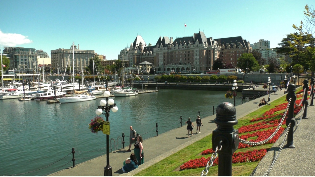 The Victoria Inner Harbor is pictured: (CTV News)
The arrival of June brings on the start of summer. So what can we expect for summer 2023? We’ll get to that in a minute.
First, let’s look back to spring, and more specifically the month of May. While it felt at times we were still stuck in winter mode, the month we just left broke that feeling in a big way.
March and April were pretty normal for the most part, although we didn’t get as much moisture as we would’ve liked. As we ended our third year with La Nina, the weather pattern held much of the big moisture to the south and gave heavy rain and bigger snow packs to California and Nevada. Here in the Pacific Northwest, we received what was left, meaning less moisture.
There were little bumps in temperature during the spring also. We had a record-setting weekend in the middle of March and we were able to determine that this year an El Nino would be building into the summer.
April was mostly typical, but as we started getting into the month of May we started seeing warmer temperatures – not just here on Vancouver Island, but across Western Canada and into parts of Ontario and Quebec.
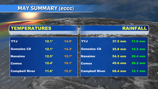
Now that May has come and gone, we can see what it did deliver weather wise. Here on the island we had the warmest May recorded. Two weather stations in Greater Victoria – the airport and Gonzales – along with stations in Nanaimo, Comox and Campbell River were all number one for heat since they started tracking data. Our mean temperatures were 2 to 4 degrees warmer throughout much of the province and with that we saw 279 extreme daytime highs and 22 precipitation records during May.
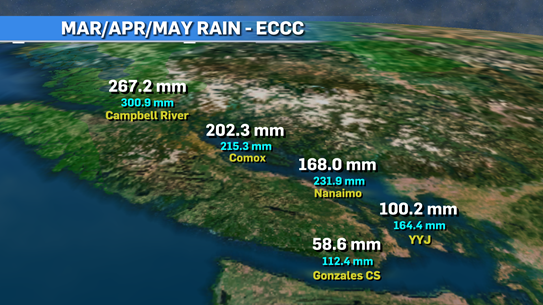
If you look at the precipitation numbers from meteorological spring (March/April/May), we can see we are lagging behind and the farther south you go, the bigger the lag is. With lower moisture numbers, we’re already preparing for a very dry summer.
As we look ahead to summer, we have already established that it’s an El Nino year and it will get stronger the deeper as we get into the year.
We’re seeing both the Pacific and Atlantic oceans warming up at a faster pace than normal and numbers seem to be approx. 1-3 degrees warmer on average.
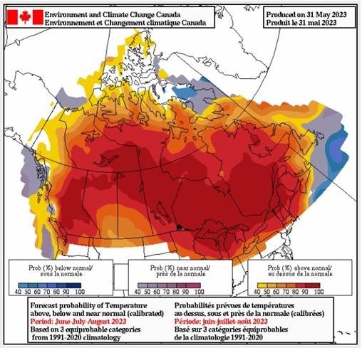
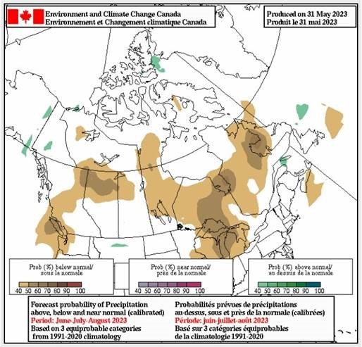
We're expecting a hotter than average summer throughout B.C. and rain seems to be lacking also.
That’s not saying we’re going to see weeks and weeks of temperatures in the 30s and 40s but it will be warmer and drier than usual and at a few points we’ll deal with heat waves and probable drought conditions through many areas.
It’s important we pay attention to the dry conditions as the risk of wildfires will be high this year. We’ve already been dealing with bad situations throughout the country.
Best case scenario is we get a run of sunshine and warm days followed by some moisture to keep things fresh. And just like your summer song this year, hopefully it stays on repeat. Of course, we know that weather doesn’t do what we want. It does what it wants and we just have to deal with it the best we can.
CTVNews.ca Top Stories

PM Trudeau says he thinks Trump is using talk of Canada becoming 51st state to distract from tariff impact
Prime Minister Justin Trudeau says he thinks U.S. president-elect Donald Trump is drumming up drama on Canadian statehood to detract from tariff talks.
LIVE UPDATES Here's the latest on the most destructive fire in L.A. County history
A series of wildfires are tearing through densely populated parts of the Los Angeles, Calif. area. Five people have been reported dead. U.S. Gov. Gavin Newsom says thousands of resources have been deployed to contain the fires.
More than 150 students sick at University of Guelph, says public health
More than 150 cases of gastroenteritis have been reported at the University of Guelph.
Multiple Chinese warships track Canadian HMCS Ottawa through the South China Sea
The silhouettes of a hulking Chinese Navy destroyer dubbed 'Changsha' and a warship called the 'Yuncheng' can been seen hovering along the horizon, mirroring HMCS Ottawa’s movements.
Canadian travellers now require an ETA to enter U.K. Here's what to know
Starting Jan. 8, Canadians visiting the U.K. for short trips will need to secure an Electronic Travel Authorization (ETA) before boarding their flight, according to regulations set out by the U.K. government.
'True when I said it, true today': former Canadian PM Harper pushes back against Trump on social media
Former prime minister Stephen Harper doesn’t find U.S. president-elect Donald Trump’s jibes about Canada becoming the 51st U.S. state very amusing.
Toronto police investigating parental abduction, three-year-old boy believed to be in India
A parental abduction investigation is underway after a father allegedly failed to return to Canada with his three-year-old son after a trip to India, Toronto police say.
California's insurance is in crisis. The solution will cost homeowners a ton
Lynne Levin-Guzman stood in the front yard of her 90-year-old parents’ home in Los Angeles County, California, trying to protect it with a garden hose — because their insurance company no longer would.
As wildfires rage in Los Angeles, Trump doesn't offer much sympathy. He's casting blame.
As cataclysmic wildfires rage across Los Angeles, President-elect Donald Trump hasn't been offering much sympathy. Instead, he's claiming he could do a better job managing the crisis, spewing falsehoods and casting blame on the state's Democratic governor.


