Vancouver Island weather forecast calls for snow, freezing rain, possible flooding
Winter weather is the gift that keeps on giving. Problem is, nobody asked for this.
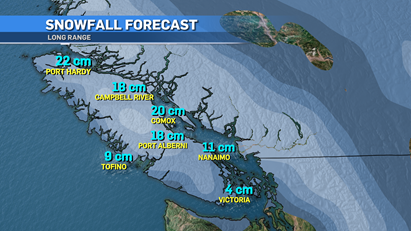
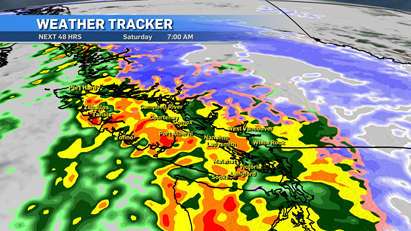
After nearly 40 centimetres of snow on Tuesday, we're getting ready for another hit. This time it’s a winter storm warning for most of Vancouver Island, while northern areas are dealing with a snowfall warning.
Either way it’s going to be a mess over the next 24 hours and into the weekend.
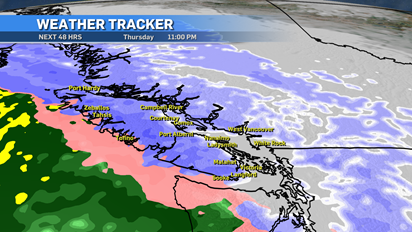
Here’s the breakdown: Thursday afternoon and into the evening, a system is pushing in from the west.
While this system will have mild air with it, we’re still dealing with cold arctic outflow, so we’re going to get a mixed bag of moisture that will cause travel issues.
Snow will be first and that will take us into the late evening hours and early overnight period.
For Greater Victoria, we’re around the five-centimetre range with the potential to get a little more depending on timing.
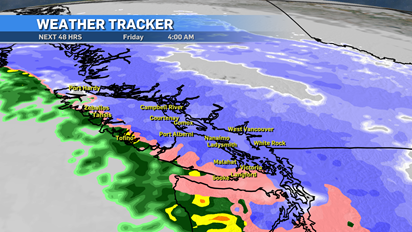
As the system moves onto the island, temperatures will warm up and we’ll shift from snow to ice pellets and freezing rain. I expect that to happen around 3 a.m. or 4 a.m. and roll through most of the morning Friday.
Obviously, this will pose issues on the roads.
On Friday afternoon, as we continue to warm up to plus-side temperatures, we’ll transition into a wet snow and rain mix.
With cold air holding on a little longer up-island, higher snowfall totals are expected and the switch to warmer temps will take longer.
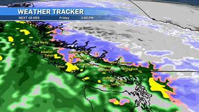
Moving into the weekend, we see the cold arctic air mass move off the island and we’ll see temperatures return to seasonal or better on Vancouver Island.
Warming up is good news but this moisture-heavy system will continue to churn with more rain right behind.
Saturday and Sunday will bring heavy downpours at times. This will add flooding concerns to the equation.
With the amount of snow we’ve received and heavy rain for a few days, that’s a lot of moisture to handle all at once.
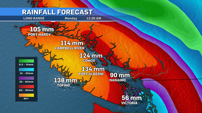
Be aware of localized flooding risks as well as mudslides.
The southwestern areas of the Lower Mainland, and more specifically the Fraser Valley, will be impacted much more with freezing rain.
The Fraser Valley tends to hold on to the cold air longer than other spots and with that will see a longer period with freezing rain. Travel will not be recommended Friday through Saturday.
Looking ahead to next week, we continue to see steady rain but also steady seasonal temperatures.
Things will settle down and we’ll get into a more typical cycle of West Coast winter weather but the next 72 hours will be messy.
Remember to move any piled up snow away from your drains, culverts and basements. Once the rain and melt starts, there’s going to be a lot of water to deal with.
Shopping Trends
The Shopping Trends team is independent of the journalists at CTV News. We may earn a commission when you use our links to shop. Read about us.


CTVNews.ca Top Stories

Jewish pro-Palestinian protesters occupy Ottawa parliament building
A group of Jewish-Canadian activists protesting Israel's ongoing armed offensive in Gaza have occupied a parliamentary building in Ottawa on Tuesday morning.
Canadian among three climbers missing on New Zealand's highest peak
A Canadian is among three climbers missing after they'd planned to climb New Zealand's highest peak.
Toronto library apologizes after staff at east-end branch refuse to help lost girl
The Toronto Public Library is apologizing after staff at a branch in the city’s east end refused to provide a lost child with access to a telephone.
Canada Post removes deadline for Santa letter program amid strike
Canada Post says it has removed the deadline for its Santa Claus letter program amid an ongoing national workers' strike that has halted mail delivery leading up to the holiday season.
2 Ontario men charged after police seize US$40M in suspected cocaine from tractor-trailer in Illinois
Two Ontario men are facing charges after police in the U.S. say they seized 540 kilograms of cocaine from a tractor-trailer along Interstate 80 in Illinois.
Quebec prisons on lockdown after correctional officer severely beaten
Quebec prisons were in lockdown on Tuesday after a correction officer at the Sorel-Tracy detention centre was attacked this week.
This salad brand is being recalled again. Here's why
A Taylor Farms salad kit is being recalled over concerns of a salmonella contamination, according to the Canadian Food Inspection Agency.
After meeting with Trump, Trudeau to brief opposition leaders
Prime Minister Justin Trudeau will meet with all opposition leaders today before question period to brief them about his meeting with U.S. president-elect Donald Trump.
Young Manitoba woman dies after medical emergency during dental appointment
The Manitoba Dental Association (MDA) said it is investigating a critical incident where a young woman from the Morden-Winkler area died following a dental appointment.
Vancouver
-

B.C. nurse suspended 8 months for sharing patient records
A British Columbia nurse has been suspended for eight months after inappropriately accessing and sharing private patient health information, according to the professional regulator.
-
Collision closes Highway 99 exit, expect delays
Commuters are advised to expect delays on the Steveston Highway following a collision Tuesday morning in Richmond, B.C.
-
Alpine Canada eyes Panorama or Whistler, B.C., for future men's World Cup downhills
Whistler and Panorama, B.C., are candidates to host men's World Cup downhill ski races in the future.
Kelowna
-

Study of 2023 Okanagan wildfires recommends limiting development in high-risk areas
A study into the devastating wildfires that struck British Columbia's Okanagan region in 2023 has recommended that government and industry limit development in high-fire-risk areas.
-
Kelowna, B.C., to host the Memorial Cup in the spring of 2026
The Western Hockey League's Kelowna Rockets will host the Memorial Cup in the spring of 2026, the Canadian Hockey League said Wednesday.
-
545 vehicles impounded in 332 days: BC Highway Patrol pleads for drivers to slow down
Mounties with the BC Highway Patrol in Kelowna say they've impounded more than 545 vehicles for excessive speed and aggressive driving so far this year. That works out to more than 1.6 per day.
Edmonton
-

Residents of Alta. town vote in favour of bylaw banning rainbow flags, crosswalks
Residents of a northern Alberta town have voted in favour of a bylaw banning Pride flags and rainbow crosswalks from municipal property.
-
Alberta RCMP officer charged with 2 counts of sexual assault
Const. Bridget Morla, a Leduc RCMP officer, has been charged with two counts of sexual assault in connection with an incident that happened two years ago.
-
Police search for man wanted in Edmonton arson, extortion cases
Edmonton police are looking for a man who they say is connected to three southside arsons this fall.
Calgary
-

Controversial Glenmore Landing redevelopment set for heated council hearing
Calgarians will have a chance to voice their opinion on a controversial development at a southwest shopping complex to city council Tuesday.
-
Calgary charity sees surge in demand for school lunches
A Calgary non-profit that's been hard at work for years packing lunches for thousands of students says their services are needed for more children than ever before.
-
2 people arrested after Vulcan, Alta., home invasion
Vulcan RCMP say two people have been arrested following a home invasion that injured a resident.
Lethbridge
-

Hurricanes add Yager, Unger in blockbuster deal with Warriors
The Lethbridge Hurricanes received forward Brayden Yager and goalie Jackson Unger from the Moose Jaw Warriors in an 11-asset blockbuster trade on Monday.
-
Raiders hand Hurricanes sixth loss in a row, winning 3-2 in Prince Albert
The Hurricanes ended November with a loss, dropping a 3-2 decision to the Raiders Saturday night in Prince Albert.
-
University of Lethbridge launches geospatial insitute
Geomatics research is about to take a step forward at the University of Lethbridge.
Winnipeg
-

Young Manitoba woman dies after medical emergency during dental appointment
The Manitoba Dental Association (MDA) said it is investigating a critical incident where a young woman from the Morden-Winkler area died following a dental appointment.
-
Winnipeg man arrested in 1997 New Jersey murder
A Winnipeg man has been arrested in connection with a cold case investigation of a 1997 murder in New Jersey.
-
'It's a little scary': Manitoba colleges and universities beefing up security measures
As of Monday, students and staff at Red River College are being greeted by security officers at the entrances, letting them know they will require ID as of Jan. 1.
Regina
-

Saskatchewan auditor to release report on foreign-owned farmland, procuring hotels
Saskatchewan's provincial auditor is to release a report today outlining government programs and services that need improvement.
-
Man fined over $10K after 35 walleye found in Sask. home, elephant ivory rosaries and rings seized
Environment and Climate Change Canada (ECCC) says a man is facing a fine of $10,550 after 35 walleye fish were found in his Saskatchewan home and four rosaries and three rings made of elephant ivory were seized after an initial search of luggage at Toronto Pearson International Airport.
-
Rural Sask. feeling effects of ongoing Canada Post strike, despite other carriers still operating
With no end in sight to the ongoing Canada Post strike, many in rural Saskatchewan are having a tough time receiving mail even with other courier's still operating.
Saskatoon
-

Meth, guns seized during drug trafficking bust in North Battleford, 3 charged: RCMP
Saskatchewan RCMP have charged three people and seized multiple guns following a drug trafficking investigation in the Battlefords area.
-
Saskatchewan auditor to release report on foreign-owned farmland, procuring hotels
Saskatchewan's provincial auditor is to release a report today outlining government programs and services that need improvement.
-
Man fined over $10K after 35 walleye found in Sask. home, elephant ivory rosaries and rings seized
Environment and Climate Change Canada (ECCC) says a man is facing a fine of $10,550 after 35 walleye fish were found in his Saskatchewan home and four rosaries and three rings made of elephant ivory were seized after an initial search of luggage at Toronto Pearson International Airport.
Toronto
-
 BREAKING
BREAKING Process around Ontario Place redevelopment was 'unfair' and didn't follow rules: AG
Ontario's auditor general is slamming the Ford government for failing to follow proper process around the redevelopment of Ontario Place, including a revelation that senior staff communicated directly with Therme Canada and other applicants while proposals were still being accepted.
-
Toronto may impose cap on number of Uber, Lyft drivers in the city
Toronto could soon introduce a cap on the number of licences issued to drivers who work for ride-hailing services, including Uber and Lyft.
-
Ontario woman tries to use Visa prepaid gift card, realizes she had been scammed
An Ontario woman was 'shocked' to find out her unused $250 gift card was almost completely drained. 'My aunt gave me this gift card as a present and I was shocked to find out it was almost empty,' Catherine Uchida, of Mississauga, told CTV News Toronto.
Montreal
-

Quebec prisons on lockdown after correctional officer severely beaten
Quebec prisons were in lockdown on Tuesday after a correction officer at the Sorel-Tracy detention centre was attacked this week.
-
Quebec to investigate 2 CEGEPs in connection with student safety
Two English-language CEGEPs in Montreal are expected to be investigated by the Quebec Ministry of Higher Education following student complaints about a tense climate due to the war in the Middle East.
-
Porch pirate arrested: Montreal man gets stolen deliveries returned
A Notre-Dame-de-Grâce (NDG) man says his community helped save his holidays after he was victim of so-called 'porch pirates.'
Ottawa
-
Jewish pro-Palestinian protesters occupy Ottawa parliament building
A group of Jewish-Canadian activists protesting Israel's ongoing armed offensive in Gaza have occupied a parliamentary building in Ottawa on Tuesday morning.
-
Ottawa to receive 5 cm of snow Wednesday, flurries Tuesday
Ottawa residents might soon have to start plowing their driveways with the city's first dump of snow expected this week.
-
Kingston, Ont. doctor in 'disbelief' after being ordered to repay $600K for pandemic vaccination payments
An Ontario health tribunal has ordered a Kingston, Ont. doctor to repay over $600,000 to the Ontario government for improperly billing thousands of COVID-19 vaccinations at the height of the pandemic.
Atlantic
-

Northern New Brunswick could see 'significant' snowfall this week
Environment Canada has issued a special weather statement in northern New Brunswick, warning the region could see 'significant' snowfall later this week.
-
Canada-wide warrant issued for N.B. man convicted of armed robbery, assault
Police in Saint John, N.B., are asking for the public’s help in finding a 26-year-old man wanted on a Canada-wide warrant.
-
This salad brand is being recalled again. Here's why
A Taylor Farms salad kit is being recalled over concerns of a salmonella contamination, according to the Canadian Food Inspection Agency.
London
-

School closures and bus cancellations, more squalls expected Tuesday morning
It remains a winter wonderland across the London region, with snow blanketing midwestern Ontario.
-
This salad brand is being recalled again. Here's why
A Taylor Farms salad kit is being recalled over concerns of a salmonella contamination, according to the Canadian Food Inspection Agency.
-
OPP seize over 50K worth of drugs in Oxford County
A traffic stop led to a significant drug bust in Oxford County.
Kitchener
-

Waterloo water main break causes traffic slowdowns
Traffic on Weber Street North has been reduced to one lane in each direction after a water main break near Lincoln Road.
-
Five men steal $2,300 in alcohol in Guelph
Guelph Police are looking for five men after they stole 30 bottles of alcohol.
-
Ontario spent highest-ever amount on government ads, auditor says
Ontario's auditor general says the province spent three times the amount of money on government advertising in the last fiscal year as it did the year before – the highest amount ever.
Northern Ontario
-

Five years after toddler's brutal death, Northern Ont. family struggles to find peace, justice
A North Bay family is struggling to find peace and justice as the five-year anniversary of the brutal death of toddler Oliver McCarthy approaches.
-
Snow squall warning in the Sault, heaviest snowfall expected tonight
Sault Ste. Marie's run of severe winter weather will continue Tuesday, with Environment Canada issuing another snow squall warning.
-
Ontario woman tries to use Visa prepaid gift card, realizes she had been scammed
An Ontario woman was 'shocked' to find out her unused $250 gift card was almost completely drained. 'My aunt gave me this gift card as a present and I was shocked to find out it was almost empty,' Catherine Uchida, of Mississauga, told CTV News Toronto.
N.L.
-

N.L. man not guilty of sex charges, judge cites inadequate police investigation
A Newfoundland and Labrador judge has acquitted a man of six crimes, including sexual assault and sexual interference, citing inadequacies in the investigation by the Royal Newfoundland Constabulary.
-
Newfoundland's LGBTQ2S+ bar paid drag queens $37.50. Tara Nova called them out.
If the screaming crowd in the twinkling Majestic Theatre in downtown St. John's was any indication, Newfoundland drag queen Tara Nova will never have to accept $37.50 for a show again.
-
'Who profits on hunger?': Inuit send pleading emails to minister about food costs
People in Nunavut and northern Labrador have been writing to Canadian government officials this year to say grocers were charging exorbitant prices despite receiving a federal subsidy.