Snowfall likely on Vancouver Island next week
 A long range forecast looking into the week of Nov. 28 to Dec. 2, 2022, is shown. (CTV News)
Weather on Vancouver Island has been pretty varied this November, and it looks like we’ll bookend the month with some snow, even in Greater Victoria.
While we’ve just enjoyed a really nice week with some great temperatures and conditions interrupting the rain activity, that will all change for the last week of the month.
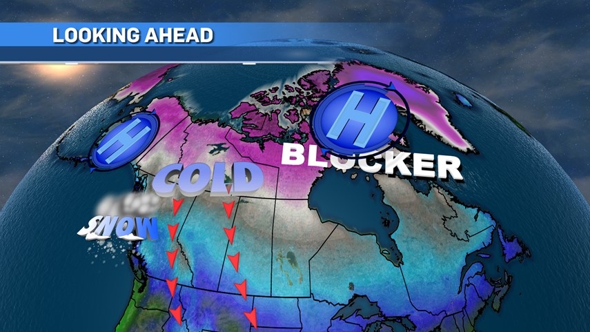
Get ready for an Arctic air push that will take us into at least the first five days of December. If you need to point fingers of blame then look to Greenland and Siberia.
Usually when we talk about a ridge of high pressure it’s positive, and we like what we see, but this time around those ridges do us no favours.
A strong ridge set up around Greenland will become a blocker and will create a little bit of a traffic jam of cold Arctic air. To the west, we’ll pull in a lot of cold air from a Siberian polar vortex thanks to a ridge setting up over Alaska.
That cold air will blanket most of the country, and for Vancouver Island and B.C. a drop to well-below seasonal temperatures will take over.
 A long range forecast looking into the week of Nov. 28 to Dec. 2, 2022, is shown. (CTV News)
Of course, it’s still autumn and that means moisture. We’ve had some nice rain this month but with this introduction of cold Arctic air our chances of snow rises big time.
We’re still going to get moisture moving into the province from the Pacific, but as it runs into the cold Arctic air we’ll go from rain to snow.
Even at sea level we’re looking to get into snowball manufacturing. Obviously higher elevations and locations up island will see more snowfall, but expect it to be spread throughout all island areas at some point.
 A long range forecast looking into the week of Nov. 28 to Dec. 2, 2022, is shown. (CTV News)
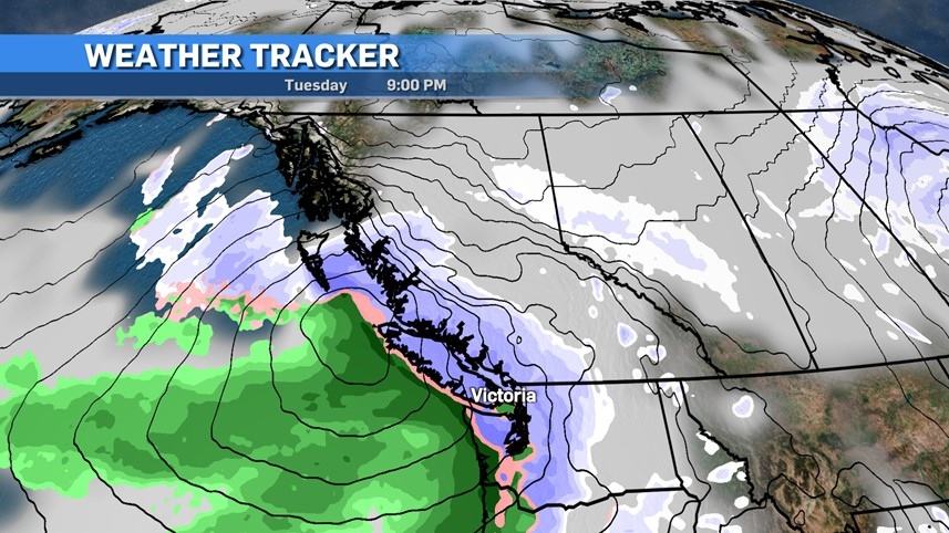
I’m circling Tuesday and Wednesday of next week to be the snowier days. While areas around the water will see more of a rain/snow mix, any precipitation falling during the night and early morning will be on the snow side of things.
It’s hard to nail down numbers at this point but as you can see on the accumulation map at the top of the article, we’ll see some noteworthy numbers, ranging from as low as one centimetre in the Comox area to up to eight centimetres in the Victoria region.
It should be noted that this particular model has a habit of overestimating snowfall totals, but I’d put Greater Victoria in the three to five centimetre range over the two-day period. High elevations could easily see double digits.
All the ingredients are there and the potential is high, but at the same time our 'snow soufflé' may collapse when we take it out of the oven and we get more rain than snow.
It’ll be a day by day and hour by hour scenario to watch. Plan for the worst and hope for the best.


CTVNews.ca Top Stories

Spectacular aurora light show to be seen across Canada Friday night
A rare and severe solar storm is expected to bring spectacular displays of the northern lights, also known as aurora borealis, across much of Canada and parts of the United States on Friday night.
Which Canadian cities have the highest and lowest grocery prices?
Where you live plays a big factor in what you pay at the grocery store. And while it's no secret the same item may have a different price depending on the store, city or province, we wanted to see just how big the differences are, and why.
McGill University seeks emergency injunction to dismantle pro-Palestinian encampment
McGill University has filed a request for an injunction to have the pro-Palestinian encampment removed from its campus.
Swarm of 20,000 bees gather around woman’s car west of Toronto
A swarm of roughly 20,000 bees gathered around a woman’s car in the parking lot of Burlington Centre.
U.S. says Israel's use of U.S. arms likely violated international law, but evidence is incomplete
The Biden administration said Friday that Israel's use of U.S.-provided weapons in Gaza likely violated international humanitarian law but wartime conditions prevented U.S. officials from determining that for certain in specific airstrikes.
Barron Trump declines to serve as an RNC delegate
Former U.S. President Donald Trump's youngest son, Barron Trump, has declined to serve as a delegate at this summer’s Republican National Convention, according to a senior Trump campaign adviser and a statement from Melania Trump's office.
Mother assaulted by stranger while breastfeeding baby in her car: Vancouver police
A person was arrested in East Vancouver Thursday after allegedly entering a car while a mother was breastfeeding her four-month-old boy.
'We have laws': Premier Smith says police action justified in Calgary
The actions, including the decision to use non-lethal force, to disperse pro-Palestinian protesters from the University of Calgary campus were justified, Alberta Premier Danielle Smith said Friday.
'State or state-sponsored actor' believed to be behind B.C. government hacks
The head of British Columbia’s civil service has revealed that a “state or state-sponsored actor” is behind multiple cyber-security incidents against provincial government networks.
Shopping Trends
The Shopping Trends team is independent of the journalists at CTV News. We may earn a commission when you use our links to shop. Read about us.


Vancouver
-

'State or state-sponsored actor' believed to be behind B.C. government hacks
The head of British Columbia’s civil service has revealed that a “state or state-sponsored actor” is behind multiple cyber-security incidents against provincial government networks.
-
Suspect fled in 2-door Fiat after convenience store robbery, Merritt RCMP say
A suspect is at large after robbing a convenience store at gunpoint in Merritt, B.C., Friday, according to local police.
-
B.C. finance minister says she will retire following provincial election this fall
British Columbia's finance minister says she won't be running again in the next provincial election after serving in the legislature for nearly two decades.
Kelowna
-

Suspect fled in 2-door Fiat after convenience store robbery, Merritt RCMP say
A suspect is at large after robbing a convenience store at gunpoint in Merritt, B.C., Friday, according to local police.
-
Kamloops RCMP issue public warning about 2 men allegedly at centre of 'organized crime conflict'
After four targeted shootings in four days, Mounties in Kamloops are taking the unusual step of warning the public about two men they believe are likely to be targeted in future violent incidents.
-
Community mourns thousands of fish lost as B.C. drought risk looms again
Images of steelhead and trout flicker over long sheets of paper, brought to life in blue and green crayon rubbings by the thousands.
Edmonton
-
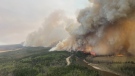
Out-of-control wildfire near Fort McMurray doubles in size Friday
The wildfire burning 25 kilometres southwest of the northeastern Alberta city doubled in size from 25 hectares at 9 a.m. to 50 hectares by 4 p.m.
-
Oilers star Leon Draisaitl questionable for Game 2 vs. Canucks
Edmonton Oilers star Leon Draisaitl is questionable for today's Game 2 against the Vancouver Canucks.
-
'Violent, despicable and unbelievable': Family of murdered 7-year-old speak at David Moss sentencing Friday
David Moss, the man who murdered seven-year-old Bella Rose Desrosiers, broke down in court Friday as the girl's family spoke about the toll her death has taken on them.
Calgary
-

'We have laws': Premier Smith says police action justified in Calgary
The actions, including the decision to use non-lethal force, to disperse pro-Palestinian protesters from the University of Calgary campus were justified, Alberta Premier Danielle Smith said Friday.
-
City of Chestermere inspection reveals ‘irregular, improper and improvident’ financial management: province
A third-party examination of the City of Chestermere revealed “significant gaps” in the financial management, the province said Friday.
-
Documents suggest Alberta's renewable-energy pause not requested by AESO head
Internal emails show the province's seven-month moratorium on renewable-energy projects was a political decision and not requested by the system operator like the premier said it was.
Lethbridge
-

Medicine Hat, Alta., police arrest local man in child luring case
Thousands of messages were sent between a teenage girl in the U.S. and an Alberta man posing as a young boy, a police investigation has revealed.
-
Southern Alberta farmers optimistic after recent rainfall
After a dry winter, southern Alberta farmers were expecting it to be another tough growing season.
-
Rural crime in decline: southern Alberta RCMP
Rural crime is on the decline, the RCMP said in a media statement released by the Southern Alberta District (SAD) late Wednesday afternoon.
Winnipeg
-

'Devastating': Clear Lake watercraft ban will have an impact, business owners say
Businesses in the Clear Lake area are concerned about the future following a temporary ban on watercraft from entering the lake.
-
Roughly 250 people forced to evacuate Winnipeg apartment building deemed unsafe
Approximately 250 residents of a St. James area apartment building will have to leave their homes immediately, as the City of Winnipeg issued a vacate order over unsafe conditions.
-
Solar storm could produce highly visible northern lights in Manitoba
An unusually large solar storm could produce northern light shows that may be visible across most of Canada on Friday and Saturday.
Regina
-

Sask. teachers set to vote on renewed sanctions mandate
Next week, teachers in Saskatchewan will vote on a renewed mandate that would implement sanctions beyond the current school year.
-
Regina police charge 3, seize drugs, ammunition after 'months long investigation'
Regina police say three people have been charged after they seized more than 1,100 grams of a substance believed to be cocaine along with suspected meth and ammunition following a “months long investigation.”
-
Which Canadian cities have the highest and lowest grocery prices?
Where you live plays a big factor in what you pay at the grocery store. And while it's no secret the same item may have a different price depending on the store, city or province, we wanted to see just how big the differences are, and why.
Saskatoon
-
Sask. teachers set to vote on renewed sanctions mandate
Next week, teachers in Saskatchewan will vote on a renewed mandate that would implement sanctions beyond the current school year.
-
Saskatoon police respond to collision involving pedestrian
Saskatoon police are responding to a collision involving a vehicle and a pedestrian near the intersection of 8th Street and Arlington Avenue.
-
Nutrien CEO wants fully automated or tele-remote operations in all 6 mines
Improved mine automation helped fertilizer giant Nutrien Ltd. increase potash production in the first quarter amid strong demand for its products, the company's chief executive said.
Toronto
-

Where and when to see the northern lights in Toronto tonight
The northern lights, also known as aurora borealis, are expected to illuminate the sky in Canada tonight, including in Toronto, thanks to a rare and severe solar storm.
-
Swarm of 20,000 bees gather around woman’s car west of Toronto
A swarm of roughly 20,000 bees gathered around a woman’s car in the parking lot of Burlington Centre.
-
3 people in hospital, including man in life-threatening condition, after collision in Bridle Path
A vehicle struck a bus shelter in Bridle Path on Friday afternoon, leaving a man in life-threatening condition.
Montreal
-

McGill University seeks emergency injunction to dismantle pro-Palestinian encampment
McGill University has filed a request for an injunction to have the pro-Palestinian encampment removed from its campus.
-
Man charged after truck strikes and kills driver changing flat tire on side of Montreal-area highway
A 43-year-old man has been charged after a driver was struck and killed while changing a tire on the side of a Highway 15 near Montreal on Thursday.
-
This iconic Canadian song is turning 50
Andy Kim's 'Rock Me Gently' is marking a major milestone, as it celebrates its 50th anniversary.
Ottawa
-

Motorcycle driver in critical condition after crash in Barrhaven
Ottawa paramedics say a man in his 20s is in critical condition after a crash in Barrhaven Friday afternoon.
-
Ottawa's 3-container limit for curbside garbage takes effect this fall
The City of Ottawa's new three-garbage item limit for household waste will take effect on Sept. 30, with a three-month phase-in period for the limit. As of December, collection staff will only collect three garbage items from households every two weeks.
-
Tiny Home Show in Edwards, Ont. showcasing miniature spaces
In the midst of soaring living expenses and spiking interest rates, the dream of owning a traditional home seems to be slipping away for many residents in Ottawa.
Atlantic
-

Seven people charged following kidnapping, assault in Tobique First Nation: N.B. RCMP
RCMP say seven people have been arrested and charged in connection with a kidnapping and assault in Tobique First Nation, N.B.
-
EHS helicopters to land in new spot in Halifax
Emergency Health Services (EHS) LifeFlight helicopters will soon be landing at Canadian Forces Base Windsor Park in the Halifax's west end.
-
'Irate male' assaulted Newfoundland officers with block of cheese, police say
Police in Newfoundland say patrol officers were assaulted Thursday by a "very irate male" wielding a block of cheese.
London
-

Suspicious fire being investigated in London
A suspicious fire in London is under investigation by police and fire officials. According to London fire, crews knocked down the scene in an “offensive strategy.”
-
Lambton County teen dies in farm accident
OPP in Lambton County are investigating what is being described as a, “sudden death.” Police responded to the call at a farm on Churchill Line in Watford around 9:30 a.m.
-
Sarnia police searching for stabbing suspect
The Sarnia Police Service has issued a warrant for a 30-year-old female in connection to a stabbing incident.
Kitchener
-

'A total write-off': Kitchener resident asks for thousands from city, after driving over 'faulty manhole cover
One driver wants the City of Kitchener to cover the thousands of dollars in damage to his car after he ran over a “faulty” manhole cover.
-
What you should keep in your emergency supply kit
Could you survive for 72 hours following a natural disaster? The Region of Waterloo is hoping that question sparks a conversation around emergency preparedness.
-
9-year-old prodigy pianist to perform with former K-W Symphony musicians
A young prodigy pianist is set to perform alongside former members of the Kitchener-Waterloo Symphony, as part of a benefit concert.
Northern Ontario
-
Spectacular aurora light show to be seen across Canada Friday night
A rare and severe solar storm is expected to bring spectacular displays of the northern lights, also known as aurora borealis, across much of Canada and parts of the United States on Friday night.
-
Dashcam video shows terrifying near-miss on two-lane northern Ontario highway
There were some scary moments for several people on a northern Ontario highway caught on video Thursday after a chain reaction following a truck fire.
-
Twenty defendants fined $222K for northern Ont. moose hunt violations
A large group of Canadian and U.S. defendants have been fined $178,400 plus $44,525 in surcharges for a variety of moose hunting violations in northwestern Ontario.
N.L.
-

'Irate male' assaulted Newfoundland officers with block of cheese, police say
Police in Newfoundland say patrol officers were assaulted Thursday by a "very irate male" wielding a block of cheese.
-
Whooping cough outbreak declared in Newfoundland
Health officials say there is an outbreak of whooping cough in eastern Newfoundland.
-
Trucker's body found in trailer in Newfoundland after failed police search in Ontario
Ontario Provincial Police are facing tough questions about their search for a missing Newfoundland trucker whose rig was found two weeks ago in Ontario, then sent back to Newfoundland, where his body was found Monday in the trailer.