Snowfall likely on Vancouver Island next week
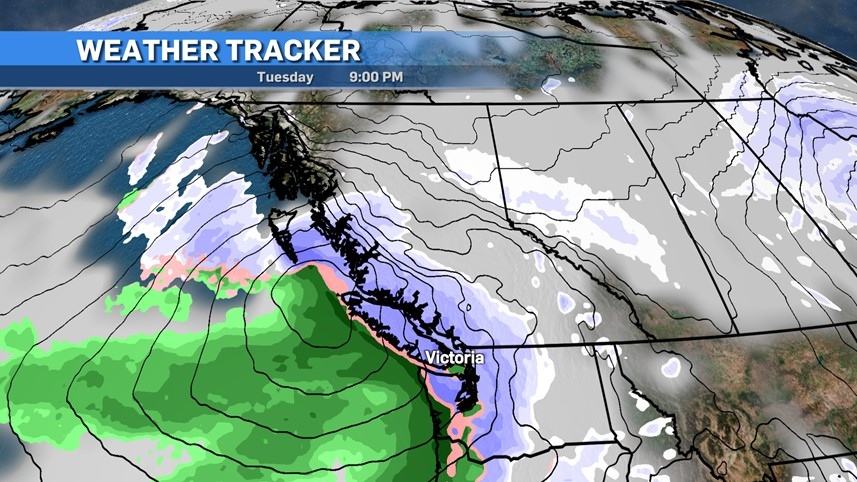
 A long range forecast looking into the week of Nov. 28 to Dec. 2, 2022, is shown. (CTV News)
Weather on Vancouver Island has been pretty varied this November, and it looks like we’ll bookend the month with some snow, even in Greater Victoria.
While we’ve just enjoyed a really nice week with some great temperatures and conditions interrupting the rain activity, that will all change for the last week of the month.
Get ready for an Arctic air push that will take us into at least the first five days of December. If you need to point fingers of blame then look to Greenland and Siberia.
Usually when we talk about a ridge of high pressure it’s positive, and we like what we see, but this time around those ridges do us no favours.
A strong ridge set up around Greenland will become a blocker and will create a little bit of a traffic jam of cold Arctic air. To the west, we’ll pull in a lot of cold air from a Siberian polar vortex thanks to a ridge setting up over Alaska.
That cold air will blanket most of the country, and for Vancouver Island and B.C. a drop to well-below seasonal temperatures will take over.
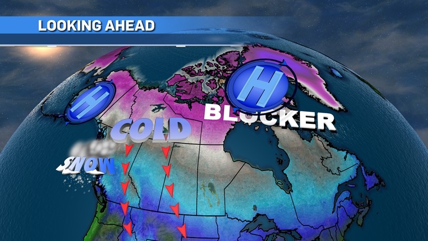 A long range forecast looking into the week of Nov. 28 to Dec. 2, 2022, is shown. (CTV News)
Of course, it’s still autumn and that means moisture. We’ve had some nice rain this month but with this introduction of cold Arctic air our chances of snow rises big time.
We’re still going to get moisture moving into the province from the Pacific, but as it runs into the cold Arctic air we’ll go from rain to snow.
Even at sea level we’re looking to get into snowball manufacturing. Obviously higher elevations and locations up island will see more snowfall, but expect it to be spread throughout all island areas at some point.
 A long range forecast looking into the week of Nov. 28 to Dec. 2, 2022, is shown. (CTV News)
I’m circling Tuesday and Wednesday of next week to be the snowier days. While areas around the water will see more of a rain/snow mix, any precipitation falling during the night and early morning will be on the snow side of things.
It’s hard to nail down numbers at this point but as you can see on the accumulation map at the top of the article, we’ll see some noteworthy numbers, ranging from as low as one centimetre in the Comox area to up to eight centimetres in the Victoria region.
It should be noted that this particular model has a habit of overestimating snowfall totals, but I’d put Greater Victoria in the three to five centimetre range over the two-day period. High elevations could easily see double digits.
All the ingredients are there and the potential is high, but at the same time our 'snow soufflé' may collapse when we take it out of the oven and we get more rain than snow.
It’ll be a day by day and hour by hour scenario to watch. Plan for the worst and hope for the best.
CTVNews.ca Top Stories

Should sex abuse evidence set the Menendez brothers free? A judge will decide
A judge will decide Monday whether new evidence warrants a re-examination of the convictions of Erik and Lyle Menendez in the shotgun murders of their parents in their Beverly Hills home more than 30 years ago.
Second Cup closes Montreal franchise over hateful incident
Second Cup Café has closed two of its franchise locations in Montreal following allegations of hateful remarks and gestures made by the franchisee in a video that was widely circulated online during a pro-Palestinian protest.
Egyptian officials say 17 people are missing after a tourist yacht sank in high waves on Red Sea
At least 17 people are missing after a tourist yacht sank in the Red Sea following warnings about rough seas, Egyptian officials said Monday.
Winnipeg police shoot, kill suspect after officer stabbed in the throat
A Winnipeg Police Service officer is recovering after he was stabbed in the throat Sunday evening.
'A first for everyone': Toronto traffic forces Utah Hockey Club to walk to Leafs game
The Utah Hockey Club got the full Toronto experience Sunday night ahead of their first-ever matchup against the Maple Leafs—bumper-to-bumper traffic that forced the team to walk to the game.
DHL cargo plane crashes and skids into a house in Lithuania, killing Spanish crew member
A DHL cargo plane crashed on approach to an airport in Lithuania's capital and skidded into a house Monday morning, killing a Spanish crew member but not harming anyone on the ground. The cause of the accident is under investigation.
Cargo ship runs aground in St. Lawrence River near Morrisburg, Ont.
A large cargo ship remains stuck in the St. Lawrence River after running aground on Saturday afternoon.
Horse's head and pregnant cow used in 'barbaric' mafia threat in Sicily
The discovery of a severed horse head, and a cow quartered with its bloodied dead calf on top, have rattled a Sicilian town, with authorities treating the incident as a mafia threat.
Legal arguments being heard in London, Ont. court in sex assault case of five hockey players
Lawyers for the players have said their clients plan to defend themselves against the allegations, and all five are expected to plead not guilty.


