Newly discovered fault line running underneath the Saanich Peninsula could be catastrophic for southern Vancouver Island
 A tiny bump in the trail around Elk Lake hides a crustal fault that could potentially span for 72 kilometres into the Haro Strait.
To the untrained eye, it’s nothing more than a tiny bump in the trail that surrounds Elk Lake. For Theron Finley, a PhD candidate at the University of Victoria in the earthquake geology department, it’s much more.
“The side that we’re on was pushed up overtop of that side,” said Finley.
It runs beneath Elk Lake, over Cordova Ridge and into Cordova Bay.
“The fault line actually runs right along the edge of this slope,” said Finley as he pointed to the lump in the trail.
It’s a newly discovered crustal fault line with the potential of causing a massive amount of damage.
“We know that the damage and the shaking would be quite severe, especially close to the fault,” said Nick Harrichhausen, researcher with the Centre National de la Recherche Scientifique in France.
A quake here could topple buildings and cause billions of dollars in damage.
It’s a scenario that researchers believe played out roughly 3,000 years ago.
“We estimate it to be a 6.1 to 7.6 magnitude earthquake,” said Finley.
The fault line was discovered through LiDAR data gathered by the province. LiDAR uses lasers to scan an area from the air, removing foliage and buildings in the process.
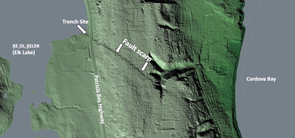 LiDAR data shows the fault line running through the Saanich Peninsula. “We had access to this LiDAR,” said Harrichhausen.
This data exposed the fault line to the UVic researchers, and that’s when the team dug deeper into the findings.
“Not only did we dig, but we also did geophysical surveys,” said Harrichhausen,
That work confirmed that yes, this is a fault line, and helped put a timeline on its last seismic movement as well as the power behind the earthquake it caused.
The big question remains: how long does this newly discovered fault line span?
“It’s a bit of an open question,” said Finley. “We have roughly a five-kilometre stretch here that we are very confident ruptured in an earthquake.”
LiDAR scanning cannot penetrate water, but evidence suggests the fault extends for 72 kilometres out underneath the Haro Strait.
With current findings only pinpointing one earthquake in the past, researchers now need to continue searching for more evidence of other shakes caused by the fault. As well, researchers need to measure how fast the fault is moving beneath our feet.
“With that data we can do a better job of calculating the probability that this type of rupture will happen within, say the next 500 years,” said Harrichhausen.
Shopping Trends
The Shopping Trends team is independent of the journalists at CTV News. We may earn a commission when you use our links to shop. Read about us.


CTVNews.ca Top Stories

W5 Investigates
W5 Investigates A 'ticking time bomb': Inside Syria's toughest prison holding accused high-ranking ISIS members
In the last of a three-part investigation, W5's Avery Haines was given rare access to a Syrian prison, where thousands of accused high-ranking ISIS members are being held.
'Mayday!': New details emerge after Boeing plane makes emergency landing at Mirabel airport
New details suggest that there were communication issues between the pilots of a charter flight and the control tower at Montreal's Mirabel airport when a Boeing 737 made an emergency landing on Wednesday.
Federal government posts $13B deficit in first half of the fiscal year
The Finance Department says the federal deficit was $13 billion between April and September.
Canadian news publishers suing ChatGPT developer OpenAI
A coalition of Canadian news publishers is suing OpenAI for using news content to train its ChatGPT generative artificial intelligence system.
Weather warnings for snow, wind issued in several parts of Canada
Winter is less than a month away, but parts of Canada are already projected to see winter-like weather.
BREAKING
BREAKING Supreme Court affirms constitutionality of B.C. law on opioid health costs recovery
Canada's top court has affirmed the constitutionality of a law that would allow British Columbia to pursue a class-action lawsuit against opioid providers on behalf of other provinces, the territories and the federal government.
Cucumbers sold in Ontario, other provinces recalled over possible salmonella contamination
A U.S. company is recalling cucumbers sold in Ontario and other Canadian provinces due to possible salmonella contamination.
Nick Cannon says he's seeking help for narcissistic personality disorder
Nick Cannon has spoken out about his recent diagnosis of narcissistic personality disorder, saying 'I need help.'
Real GDP per capita declines for 6th consecutive quarter, household savings rise
Statistics Canada says the economy grew at an annualized pace of one per cent during the third quarter, in line with economists' expectations.
Vancouver
-

Surrey Police Service officially takes over from the RCMP after years-long saga
The years-long saga over who will police the city of Surrey has reached its final chapter.
-
How changing catch-and-release fishing practices can boost salmon survival
A study has found catch-and-release sportfishing practices that leave salmon with injuries, particularly to their eyes, cause higher mortality than earlier research suggested.
-
BREAKING
BREAKING Supreme Court affirms constitutionality of B.C. law on opioid health costs recovery
Canada's top court has affirmed the constitutionality of a law that would allow British Columbia to pursue a class-action lawsuit against opioid providers on behalf of other provinces, the territories and the federal government.
Kelowna
-

Kelowna, B.C., to host the Memorial Cup in the spring of 2026
The Western Hockey League's Kelowna Rockets will host the Memorial Cup in the spring of 2026, the Canadian Hockey League said Wednesday.
-
545 vehicles impounded in 332 days: BC Highway Patrol pleads for drivers to slow down
Mounties with the BC Highway Patrol in Kelowna say they've impounded more than 545 vehicles for excessive speed and aggressive driving so far this year. That works out to more than 1.6 per day.
-
Man in hospital following targeted shooting in Kamloops
Police are appealing for information on a targeted shooting that resulted in the hospitalization of a man in Kamloops.
Edmonton
-

Oilers rightly optimistic they can pull themselves into NHL playoff picture. Again
Hockey fans know the adage: U.S. Thanksgiving, while unofficial, serves as a great calendar marker in predicting which teams will make the National Hockey League playoffs.
-
ATV driver killed in crash on Sturgeon Lake Cree Nation
A 31-year-old man was killed in a crash on Sturgeon Lake Cree Nation on Thursday.
-
WEATHER
WEATHER Josh Classen's forecast: A few more cold and snowy days, then the deep freeze breaks
We'll close out November with two more frigid days and Sunday doesn't look much warmer.
Calgary
-
 BREAKING
BREAKING Calgary Mayor Jyoti Gondek running for re-election
Calgary Mayor Jyoti Gondek has announced she will run for re-election in the next municipal election in 2025.
-
Multiple crashes reported on Deerfoot Trail
Calgary police say there are at least three major crashes on Deerfoot Trail on Friday morning as frigid overnight temperatures likely led to icy conditions in many areas.
-
Black Friday deals look to appeal to budget-friendly Calgary shoppers
Black Friday sales are in full swing as annual holiday shopping returns and Calgary retailers are competing harder than ever to coax budget-conscious shoppers into a deal.
Lethbridge
-

Lethbridge Hurricanes name 3 new members to its Wall of Honour
The Lethbridge Hurricanes’ Wall of Honour will be getting a little more crowded.
-
Avonlea Homes team members go on shopping spree for Lethbridge Family Services' Angel Tree Campaign
The Christmas spirit was on full display Thursday morning inside Toys "R" Us thanks to the team from Avonlea Homes, who spent their morning buying toys and gifts for Lethbridge Family Services’ Angel Tree Campaign.
-
Marshal Iwaasa's family still seeks answers five years after his disappearance
On Nov. 17, 2019, 26-year-old Marshal Iwaasa left his mother's home in Lethbridge and told his family he was driving to Calgary.
Winnipeg
-

Hanover School Division laying off 93 EAs due to confusion over funding
The Hanover School Division is laying off 93 educational assistants, citing an "unexpected loss of federal funding for Jordan's Principle programming."
-
Water main break causing Friday morning traffic delays in Winnipeg
Winnipeg drivers are being warned of traffic delays on Friday morning due to a water main break.
-
A tale of two downtowns: Restaurants opening and closing show complexity of downtown revival
Proposed developments and new businesses opening are fueling optimism for some on a revival of downtown Winnipeg, but some business owners say the present remains problematic.
Regina
-

Crown gives final remarks in Ruben Manz case as argument to jury concludes
The prosecution has presented their closing remarks against Ruben Manz to a 13-person jury, bringing an end to arguments before their sequestering.
-
Youngest roping duo looking for repeat performance at Agribition Rodeo
Kavis Drake, 18, and Denim Ross, 20, won the average in last year’s Maple Leaf Finals Rodeo team roping event at Agribition. The two were the youngest competitors in 2023 and are once again in their event this year.
-
Canada Post temporarily laying off striking workers, union says
The union representing Canada Post workers says the Crown corporation has been laying off striking employees as the labour action by more than 55,000 workers approaches the two-week mark.
Saskatoon
-

Ontario men arrested after Saskatoon police seize 16 kilos of meth, nearly $70K in cash
Saskatoon police say officers arrested three 20-year-old men Wednesday afternoon and seized nearly $70,000, in cash as well as various illicit drugs.
-
Extreme cold warning issued for Saskatoon
Environment Canada has issued an extreme cold warning for parts of central Saskatchewan, including Saskatoon, on Thursday.
-
Sask. forecasting $743.5M deficit in mid-year financial report, up $470.5M from budget
The provincial government says increases to crop insurance claims later in the growing season are a main reason for Thursday’s mid-year deficit forecast of $743.5 million, which is up more than $470 million from the budget.
Toronto
-

Black Friday sales stretch out for weeks: retail analyst
Black Friday is officially the busiest shopping day of the year, even surpassing Boxing Day and Super Saturday, the final Saturday before Christmas. Analysts say retailers are rolling out Black Friday sales sooner now, making them last longer into Cyber Monday and beyond.
-
Cucumbers sold in Ontario, other provinces recalled over possible salmonella contamination
A U.S. company is recalling cucumbers sold in Ontario and other Canadian provinces due to possible salmonella contamination.
-
House fire in North York sends 6 people to hospital
Six people are in hospital as a precaution after a fire broke out in a North York home overnight.
Montreal
-

Quebec will try to 'minimize' impact of health care cuts on services
Eliminating $1.5 billion in health spending is likely to have an impact on services, but Quebec will try to "minimize" it.
-
'Mayday!': New details emerge after Boeing plane makes emergency landing at Mirabel airport
New details suggest that there were communication issues between the pilots of a charter flight and the control tower at Montreal's Mirabel airport when a Boeing 737 made an emergency landing on Wednesday.
-
As Australia bans social media for children, Quebec is paying close attention
As Australia moves to ban social media for children under 16, Quebec is debating whether to follow suit.
Ottawa
-

'Dude, Where's My Bus?' Ottawa man fed up with OC Transpo makes documentary exploring transit troubles
Gio Petti put together a documentary on OC Transpo, asking how we got here. How did a city that was once lauded as an example of how to do transit right, and that boasted some of the highest per capita transit ridership numbers in the country, become a system that now elicits so much frustration from users?
-
Ottawa police charge two adults, teenager following Orleans kidnapping and robbery
The Ottawa Police Service says two adults and a teenager are facing multiple charges following a kidnapping, robbery and extortion incident that happened last month in Orleans.
-
Ottawa to begin full enforcement of 3-item garbage limit on Monday: Here’s what you need to know
The City of Ottawa will begin the final phase of the graduated approach to enforcing the city’s new three-item garbage limit on Monday, leaving behind any extra items not in a yellow bag.
Atlantic
-

Some closures, power outages in the Maritimes with first storm of the winter season
Parts of the Maritimes are experiencing their first winter storm on Friday with a messy weather system moving north from the eastern U.S.
-
Committee tracking mass casualty commission recommendations gives report on progress
The committee monitoring progress on the 130 recommendations made by the Mass Casualty Commission said progress is being made in three key areas, including gender-based intimate partner violence, access to firearms and police oversight.
-
Gas prices fall in N.S., P.E.I., increase slightly in N.B.
Gas prices change in all three Maritime provinces.
London
-

Sarnia police lay charges after women wakes up to naked man in her home
An arrest has been made after a break and enter call in Sarnia where a woman woke up to a naked man in her home. Police said after investigating, officers were able to identify a 26-year-old man who was also wanted on an outstanding warrant in London.
-
Knights' Boulton hit with eight-game suspension
The left winger has been suspended eight games, retroactive to Nov. 23 against Saginaw, when he was handed a major penalty for slashing, along with a game misconduct.
-
'Shock, disappointment, and excitement': South Bruce not selected for nuclear waste project
Anja Vandervlies and Michelle Stein could hardly believe it when they heard South Bruce was not going to host Canada’s first permanent storage facility for nuclear waste.
Kitchener
-

One dead, another hurt in Cambridge shooting
Waterloo Regional Police are investigating a fatal shooting in Cambridge.
-
Police looking for missing teen last seen in Cambridge
Waterloo Regional Police are looking for information about the whereabouts of a missing teen.
-
Mother from Guelph, Ont. seeks answers following son's death in prison
Brody Robinson was found without vital signs in his cell at Millhaven Institution the evening of Oct. 29. He was 23-years-old.
Northern Ontario
-

Another 50 cm of snow possible in the Sault as severe weather continues
Closures and cancellations are piling up in Sault Ste. Marie as a major winter storm continues for another day Friday.
-
Ongoing bed bug issue at a Timmins apartment building is 'like living in hell'
A battle with bed bugs continues at 217 Pine St. North in Timmins, according to a tenant who has lived there for a year and a half.
-
California man who went missing for 25 years found after sister sees his picture in the news
It’s a Thanksgiving miracle for one California family after a man who went missing in 1999 was found 25 years later when his sister saw a photo of him in an online article, authorities said.
N.L.
-

'Who profits on hunger?': Inuit send pleading emails to minister about food costs
People in Nunavut and northern Labrador have been writing to Canadian government officials this year to say grocers were charging exorbitant prices despite receiving a federal subsidy.
-
As N.L. firm pivots, scientists say Canada's green hydrogen dreams are far-fetched
A Newfoundland energy company's embrace of data centres is raising doubts about eastern Canadian hopes of harnessing the region's howling winds to supply Germany with power from green hydrogen.
-
Canadian leads group pushing Vatican for zero-tolerance policy on abuse by clergy
An international group led by a Canadian is in Rome this week to push the Catholic Church to adopt a zero-tolerance policy on abuse by clergy.