Explaining Vancouver Island's unusual April snowfall
It looks like we sprang ahead too far and skipped summer and fall and got right back to winter. What is happening with the weather right now?
We’re dealing with a late winter push in early spring on Vancouver Island, and while it's not typical, it does sometimes happen.
The island's not alone with its unusual weather, as the system that started all this on Sunday is now moving into the Prairies with more punch and a bigger blast of winter than we’re dealing with.
Snow, wind and cold temperatures will be on the menu for Alberta, Saskatchewan and Manitoba, but they’re used to that at this time of year and we’re not.
So what is going on and why is this happening? It’s a few moving parts all happening at the same time to deliver one last push of the fourth season.
A low pressure system moved across the island on Sunday. While Tuesday's system was developing, the jet stream was pushing out to the west and dropping south. This allowed more of a northeasterly flow to push colder air into the area. As lows spring in a counter clockwise motion, that helped pull colder air in.
 April 12, 2022. (CTV News)
So you have a system that is filled with moisture and drawing in Arctic air, all of this happening at a low level in the atmosphere and delivering moisture as snow in more areas than usual.
We also have some convective energy as part of the equation and that developed some weak thunderstorms.
In the Nanaimo area, some folks were lucky enough to capture thundersnow – a thunderstorm while it snows.
 April 12, 2022. (CTV News)
As we moved into Monday this moisture laden low moved south and kept dropping snow throughout the Northwest Pacific states, even giving some snow to Northern California. This first low pressure system continues to roll and will be frustrating Prairie residents over the next 24-36 hours.
As that system moved off the island we saw another small and weaker low develop at the northern tip of Vancouver Island. Again, this is where the motion of a low comes into play, with that counter clockwise spin it’s again drawing in colder air as well as tapping into the backend of the first bigger low.
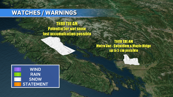
What does this mean? Snowfall warnings remain for areas of the island Tuesday, and we may see them shift to other spots with more snow potential as we get into Tuesday night and Wednesday morning.
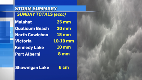
The snow into Wednesday should stay more to the west side of the island. Zeballos, Tahsis, Tofino, Port Alberni and even Port Renfrew have the best chance of a fresh white blanket.
 April 12, 2022. (CTV News)
The best part about this is that even though we’re below seasonal with our temperatures, it’s still warm enough to melt most of the snow on impact and it’s not sticking around for long. It’ll melt fast and we can keep trucking towards true spring.
It’s a balancing act for the atmosphere at this time of year and right now we’re not tipping in the right direction. This dance will continue for the rest of the month – this angry, uncoordinated, frenzied dance that is spring on the West Coast.


CTVNews.ca Top Stories

Prosecutor recommends parole for Menendez brothers in 1989 murder of parents
A Los Angeles prosecutor said on Thursday he would ask a judge to release Erik and Lyle Menendez on parole after nearly 35 years in prison for the shotgun murder of their parents, as new evidence emerged indicating they were sexually abused by their father for years.
'The mom is shattered': Body of employee who died at Halifax Walmart was found by her mother
The Maritime Sikh Society says the body of a young employee who died at a Walmart in Halifax last weekend was found by her mother.
'Never said I was going to close the door on politics forever': Christy Clark on interest in federal leadership run
As Prime Minister Justin Trudeau faces growing pressure from within his own caucus to step aside, former B.C. premier Christy Clark says she is open to returning to politics.
Trudeau announces massive drop in immigration targets as Liberals make major pivot
The federal government is slashing immigration targets to levels that will flatten population growth as Prime Minister Justin Trudeau admits the government did not get the balance right after the COVID-19 pandemic.
2 suspects arrested after 4 teens stabbed outside Montreal high school
Montreal police say four teenagers suffered stab wounds after an altercation near John F. Kennedy High School in the city's Villeray—Saint-Michel—Parc-Extension borough on Thursday.
'Horrific': Four people dead after Tesla slams into pillar and catches fire on Lake Shore Boulevard in Toronto
Four people are dead and another is in hospital after a Tesla driving through downtown Toronto at a high rate of speed crashed into a guardrail and struck a concrete pillar on Lake Shore Boulevard.
More straight couples are calling each other partner. Here's why
Within a year of dating, 31-year-old Siara Rouzer crossed a major relationship milestone. The guy she was seeing was no longer a boyfriend but her partner.
Vince McMahon, embattled former CEO of WWE, sued for allegedly enabling sexual abuse
A new lawsuit alleges Vince McMahon knowingly enabled the sexual exploitation of children by a WWE employee in the 1980s.
B.C. election recounts won't start until Sunday afternoon
Voting officials say recounts in two ridings that could determine the outcome of British Columbia's election won't start until Sunday afternoon — and it won't be until Monday before the makeup of the legislature is finalized.
Shopping Trends
The Shopping Trends team is independent of the journalists at CTV News. We may earn a commission when you use our links to shop. Read about us.


Vancouver
-

In 2022, Vancouver Mayor Ken Sim promised to hire 100 cops and 100 nurses. Here's what's actually happened so far.
An update on the health-care piece of Mayor Ken Sim's pledge to hire 100 mental health nurses to pair with 100 police officers has revealed just how little resemblance what is being implemented bears to what was promised in 2022.
-
Man tries to save salmon swimming in Port Coquitlam streets during B.C. storm
Many roads looked more like rushing rivers during last weekend's atmospheric river, and some fish seemed to think so as well.
-
B.C. election recounts won't start until Sunday afternoon
Voting officials say recounts in two ridings that could determine the outcome of British Columbia's election won't start until Sunday afternoon — and it won't be until Monday before the makeup of the legislature is finalized.
Kelowna
-

B.C. homeowner astounded someone managed to steal one of his prized giant pumpkins
Dave Lindsey began growing giant pumpkins to bring a bit of magic to his grandkids' Halloween.
-
B.C. man gets prison sentence, fine for using fake names to buy guns in the U.S.
A U.S. District Court judge in Montana has sentenced a 27-year-old man from Kelowna, B.C., to 18 months in prison for using fake names to buy guns with the aim of selling them in Canada.
-
2nd-degree murder charge laid nearly 2 years after Kelowna stabbing
Nearly two years after a man was stabbed to death in downtown Kelowna, RCMP have made an arrest in the case.
Edmonton
-

Father of murdered Beaumont woman's boyfriend to serve prison time after appeal
The man who cut up the body of his grandson's mother is going to prison after the Alberta Court of Appeal overturned his previous sentence.
-
How have usage and the cannabis retail market changed since legalization?
In the six years since cannabis was legalized in Canada, the industry has gone through rapid growth, increased uptake and better awareness of side effects.
-
Man hospitalized with life-threatening injuries after Edmonton shooting
One person was taken to hospital with life-threatening injuries after a reported shooting on Wednesday night.
Calgary
-

'It’s brutal': Calgary company steaming mad after Google removes business profile
A Calgary business owner is frustrated and looking for answers after Google removed his business' profile without warning, resulting in a loss of bookings and damage to his company’s reputation.
-
University of Calgary grad students facing 'uncertainty' after recent immigration changes
International graduate students at the University of Calgary say recent changes to the cap on international students, along with more cuts to Canada's immigration targets, is causing uncertainty -- and could drive talent away from the country.
-
Southeast Calgary community almost too famous for handing out 2-litre bottles of pop on Halloween
A house in southeast Calgary is expected to be very, very busy on Halloween.
Lethbridge
-

More listening and strategizing essential to Crowsnest tourism success, NDP says
The Municipality of Crowsnest Pass deserves a better shot at becoming a significant tourism hub than the UCP government is giving it, an NDP shadow minister said as the southeastern Alberta community gears up for a coal mining plebiscite.
-
Hitmen kick off 3-game road trip on wrong foot, dropping 4-2 decision to Tigers
A three-game road trip across the prairies got off on a sour note Wednesday night as the Medicine Hat Tigers defeated the Calgary Hitmen 4-2.
-
Golf carts allowed on roads in some Alberta communities as part of pilot
A town in southern Alberta will be one of the first to let golf carts be driven on select roads as part of a provincial pilot program.
Winnipeg
-

'Just horrible': Manitoba man sentenced to life in prison for murdering partner, children
The Manitoba man who brutally murdered his partner and two young children stood in court, voice wavering, and apologized for his actions that ended the lives of three people he said he loved very much.
-
'Sends a strong message to us': Pair of RM of Springfield councillors want to opt out of Plan 20-50
A pair of councillors in the RM of Springfield plan on bringing forward a motion to opt out of Plan 20-50 when they are first able to.
-
Teen charged after stolen vehicle damages home, property in St. Boniface: police
A Winnipeg teenager has been charged with multiple offences after a stolen car crashed in St. Boniface Thursday morning.
Regina
-

Here's how many have people have already voted in Saskatchewan's election
After two days of advance polls, more than 119,000 people have already cast a ballot in-person for the 2024 Saskatchewan election.
-
Shercom announces more layoffs as Sask. tire recycler transitions to 'skeleton' staff
A former tire recycling company in Saskatoon is announcing additional layoffs months after a dispute with the provincial government.
-
One killed, 2 hurt in collision north of Regina
A man is dead and two other people were injured in a two vehicle collision north of Regina on Wednesday evening.
Saskatoon
-

Two arrested in northern Saskatchewan after all-day manhunt for armed auto thieves
The Saskatchewan RCMP is calling off its dangerous persons alert after two people were arrested in the Tobin Lake area Thursday afternoon.
-
Shercom announces more layoffs as Sask. tire recycler transitions to 'skeleton' staff
A former tire recycling company in Saskatoon is announcing additional layoffs months after a dispute with the provincial government.
-
Police investigating multiple suspicious fire in Saskatoon Mayfair neighbourhood
Saskatoon police are investigating a series of suspicious fires that were lit in the Mayfair neighbourhood on Thursday morning.
Toronto
-

Court documents reveal new details about U.S. probe into ex-Canadian Olympian accused of running drug trafficking ring
U.S. authorities earlier this year knew the whereabouts of a former Canadian Olympian who is now on the run for allegedly running a transnational drug trafficking ring and orchestrating murders in Ontario, according to Ontario court documents.
-
'Horrific': Four people dead after Tesla slams into pillar and catches fire on Lake Shore Boulevard in Toronto
Four people are dead and another is in hospital after a Tesla driving through downtown Toronto at a high rate of speed crashed into a guardrail and struck a concrete pillar on Lake Shore Boulevard.
-
Ontario family loses dream home after $38K deposit falls through
It's a dream for many Canadians, trying to save up enough money for a down payment on their very first home. That was also the dream for the Esmeralda family, a family of five with two dogs who currently live in a Scarborough apartment building.
Montreal
-

2 suspects arrested after 4 teens stabbed outside Montreal high school
Montreal police say four teenagers suffered stab wounds after an altercation near John F. Kennedy High School in the city's Villeray—Saint-Michel—Parc-Extension borough on Thursday.
-
'Early detection is key': Beyonce's dad speaks in Montreal about personal journey with breast cancer
October is Breast Cancer Awareness Month and on Thursday the Quebec Breast Cancer Foundation held a brunch in downtown Montreal featuring a special guest: Matthew Knowles.
-
Medical assistance in dying: Quebec says it's ready to start accepting advanced requests next week
Quebec's health department says it will be ready to meet the expected demand for advanced applications for medical assistance in dying when it begins accepting those requests next week.
Ottawa
-

Police identify woman stabbed to death in park in Ottawa's south end
The Ottawa Police Service has identified the woman who was stabbed to death at Paul Landry Park on Uplands Drive Thursday morning.
-
Actor Matthew Perry's legacy to live on through Canadian foundation to aid people with addictions
A new organization that aims to help people struggling with addiction officially launched in Ottawa Thursday, named after the late Matthew Perry.
-
43rd annual Snowsuit Fund season kicks off in Ottawa
The Snowsuit Fund has officially launched its 43rd annual campaign in Ottawa to provide outdoor gear to low-income families and newcomers to Canada.
Atlantic
-

'The mom is shattered': Body of employee who died at Halifax Walmart was found by her mother
The Maritime Sikh Society says the body of a young employee who died at a Walmart in Halifax last weekend was found by her mother.
-
'This sudden loss is felt deeply': Man killed in workplace accident at Moncton tire shop
WorkSafeNB is investigating after a man was killed in a workplace incident at a tire shop in Moncton, N.B., last week.
-
N.S. Liberals accuse former member Fred Tilley of data breach
The Nova Scotia Liberals are accusing former member Fred Tilley of accessing party files one day before he crossed the aisle to join the Progressive Conservatives.
London
-

Bush party shooting witness: the accused 'had a gun in his car'
When she took the stand at a London courthouse on Thursday, 21-year-old Kaiah Edmonds testified that she arrived at the bush party off of Pack Road in a vehicle driven by one of the accused - Carlos Guerra Guerra.
-
Hyde Park BIA sets its sights on expanded boundaries, and customized approach
The Hyde Park Business Improvement Association is taking steps to re-brand and dramatically expand its boundaries.
-
Group of friends robbed at knifepoint, London police hope to ID suspect
London police are asking for the public’s help identifying a suspect involved in a robbery on Sunday.
Kitchener
-

Erick Buhr insists he didn't kill his grandmother while testifying at second-degree murder trial
Erick Buhr, the man on trial for second-degree murder in the death of his grandmother Viola Erb, took the stand Thursday to testify in his own defense.
-
Guelph, Ont. couple using social media to find surrogate
One Ontario couple is taking a different approach to growing their family.
-
Court documents reveal new details about U.S. probe into ex-Canadian Olympian accused of running drug trafficking ring
U.S. authorities earlier this year knew the whereabouts of a former Canadian Olympian who is now on the run for allegedly running a transnational drug trafficking ring and orchestrating murders in Ontario, according to Ontario court documents.
Northern Ontario
-
'The mom is shattered': Body of employee who died at Halifax Walmart was found by her mother
The Maritime Sikh Society says the body of a young employee who died at a Walmart in Halifax last weekend was found by her mother.
-
North Bay soup kitchen fights to stay open after $140K funding request denied
The Gathering Place board chair Peter Gregory is vowing to fight to keep the doors to the Cassells Street soup kitchen open after the District of Nipissing Social Services Administration Board denied their six-figure funding request.
-
Sudbury police searching for suspect in dangerous driving incident
Greater Sudbury Police have released a photo of a person they say escaped by driving their motor vehicle on a sidewalk past pedestrians and then the wrong way down a one-way street.
N.L.
-

Remains of missing Kansas man found at scene of western Newfoundland hotel fire
Investigators found the remains of a 77-year-old American man on Wednesday at the scene of a fire that destroyed a hotel in western Newfoundland earlier on the weekend.
-
77-year-old Kansas man missing after hotel fire in western Newfoundland
Police in western Newfoundland say a 77-year-old man visiting the province from Kansas is missing after a fire at a hotel in Deer Lake, N.L.
-
83-year-old Newfoundland musician still playing sold-out shows, even with memory loss
At 2 p.m. on Thursday, the scene at the Lions Club in Clarenville, N.L., rivalled any rowdy St. John's bar that thumps with music late on a weekend night.