Examining what snowfall warnings will actually mean for Vancouver Island
2021 was a busy, exciting, interesting and unique weather year on the West Coast, and 2022 continues that trend.
Another wallop of winter weather is hitting Vancouver Island with widespread snow, freezing rain, wind gusts and more rain. It’s going to get messy.
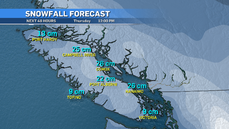
The island is blanketed with snowfall warnings, with 10 to 25 centimetres expected Wednesday afternoon into Thursday morning.
 Jan. 5, 2022 (CTV News)
Heavy bands of snow associated with this system will make road conditions deteriorate fast with quick accumulation for some areas and reduced visibility.
Easterly winds will gust into the 50-60 km/h range and that flow is also injecting cold Arctic air throughout B.C. and giving us the white precipitation.
 Jan. 5, 2022 (CTV News)
While this storm will bring a lot of snow, Thursday morning that snow will turn over into freezing rain, and then rain.
It’s the freezing rain that will make for bigger concerns on the roads and highways, as well as sidewalks. Icy and slippery conditions will develop quickly.
Once the rain takes over we’ll be dealing with a messy mix for couple of days.
Warmer temperatures will arrive this weekend and we’ll see some stability with more typical weather into next week and throughout the rest of January for the most part.
 Jan. 5, 2022 (CTV News)
(NOTE: The rainfall totals graphic includes the moisture from the snow so numbers are a little higher than what will actually fall just as rain)
SNOW BY REGION
The areas expected to be hardest hit with snow will be East Vancouver Island, from Nanaimo to Campbell River. Higher elevations inland will also see some bigger snowfall numbers.
West Vancouver Island could see up to 10 centimetres, especially a little more inland, and can expect more freezing rain than other areas.
North Vancouver Island could see up to 30 centimetres plus strong wind gusts producing white out conditions and cold wind chill values.
Greater Victoria and southern portions of the island will also deal with snow and wind. Eight to 10 centimetres is very likely. Spots near the water will be on the low end, roughly three to five centimetres, but snow will be widespread.
As Thursday continues on, moisture will change into rain, and some decent rainfall numbers will be had.
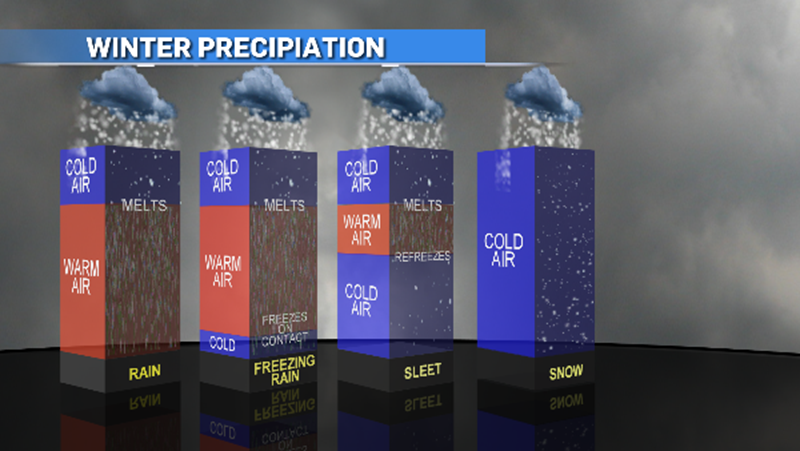
DIFFERENT TYPES OF PRECIPITATION
Forecasting snow in the island is like a carnival game. Sometimes you win, but most times there’s a catch and it doesn’t go the way you think it will.
From sea level bays and beaches to mountain ranges, the changes in temperatures and air flow can be dramatic and can change the form of moisture quickly.
With an Arctic outflow feeding into this Pacific system we know that cold air will make most of that moisture snow – but how much, where, and when is always, literally, up in the air.
We’ll get a little bit of everything this time around. Below is a graphic to help explain what conditions are needed to created different forms of precipitation.
 Jan. 5, 2022 (CTV News)
After we get through this storm then we’ll settle down and get back to more typical conditions, but the moisture will continue to roll across the island. Whether it’s snow, freezing rain, ice pellets, or rain, the moisture is a big positive after a very dry 2021.
Shopping Trends
The Shopping Trends team is independent of the journalists at CTV News. We may earn a commission when you use our links to shop. Read about us.


CTVNews.ca Top Stories

Calgary woman stranded in Mexico after husband's death during diving trip
A Calgary woman is struggling to return home after her husband died while diving in Mexico, leaving her stranded and facing financial hardship.
'Inadmissible' foreign nationals to pay more upon return to Canada: CBSA
Foreign nationals who refuse or are unable to pay their own way home after being denied stay in Canada will soon face steeper financial penalties should they ever attempt to return.
Sea and Himalayan salts recalled in Canada: 'Do not use, serve or distribute'
Two brands of sea and Himalayan salt are being recalled in Canada due to pieces of plastic found in the products.
Liberal caucus chairs meet to talk Trudeau, PM attends Canada-U.S. cabinet committee
Prime Minister Justin Trudeau was back in Ottawa today, but having yet to signal he's ready to address the snowballing resignation calls, the Liberal caucus' regional chairs called a meeting today to discuss next steps.
N.S. community shocked by deaths of father, daughter; suspect was wanted in Toronto shooting
A Nova Scotia community is mourning the loss of two of its members after they were shot and killed in Halifax on New Year’s Eve.
Judge sets Trump's sentencing in hush money case for Jan. 10, but signals no jail time
In an extraordinary turn, a judge Friday set U.S. president-elect Donald Trump's sentencing in his hush money case for Jan. 10, but indicated he wouldn't be jailed.
'Mystery volcano' that erupted and cooled Earth in 1831 has finally been identified
An unknown volcano erupted so explosively in 1831 that it cooled Earth's climate. Now, nearly 200 years later, scientists have identified the 'mystery volcano.'
When do I receive federal benefits this year? Payment dates for 2025
From the Canada Child Benefit to Old Age Security, federal payment dates have been determined for 2025. Find out when you can expect your payments.
Ontario aiming to send out $200 rebate cheques later this month or early February
Ontarians should receive their $200 rebate cheque from the province by the end of January or early February, a government spokesperson confirmed in an email Friday.
Vancouver
-

B.C. driver who tried to apprehend suspected impaired driver was impaired: RCMP
Mounties on Vancouver Island say a 50-year-old motorist who tried to apprehend a suspected impaired driver on New Year's Eve, was, in fact, impaired and was issued a 90-day driving prohibition by police.
-
A parking spot in Whistler, B.C. is on the market for $110K
Any skiers looking to avoid circling the parking lots at the world-famous Whistler Blackcomb resort can now solve that problem—but it comes with a six-figure price tag.
-
Attending hundreds of serious crash scenes each year takes its toll, B.C. first responders say
Just days into the new year, officials are already pleading with British Columbians to follow the rules of the road.
Kelowna
-

Charges laid after child porn investigation that 'spanned several different countries,' Kelowna RCMP say
Police in Kelowna say an international investigation has led to child pornography charges against a 46-year-old man.
-
Mounties investigate discovery of 'very small pipe bomb' in Kamloops, B.C.
Mounties are investigating and appealing for witnesses after an explosive device was discovered Wednesday on a beach in Kamloops, B.C.
-
Kamloops couple delivers B.C.'s first baby of 2025
B.C.'s first baby of 2025 was born just after midnight at Royal Inland Hospital in Kamloops.
Edmonton
-

Homicide investigation underway after woman found dead on Edmonton riverbank
Police have identified a woman who was recently found dead on the shore of the North Saskatchewan River in Edmonton.
-
'Flames were shooting higher than the garage': Block heater cords cause 2 fires in 2 days in Edmonton
Peter Claffey was shocked Thursday morning to find his truck in flames outside his southwest Edmonton home.
-
Edmonton's Food Bank hits cash goal, comes up short on food donations
Edmonton's Food Bank holiday donation campaign surpassed its monetary goal in 2024, but has struggled to bring in the food it needs to stock the shelves this year.
Calgary
-
Calgary woman stranded in Mexico after husband's death during diving trip
A Calgary woman is struggling to return home after her husband died while diving in Mexico, leaving her stranded and facing financial hardship.
-
Calgary police seek driver of 'red vehicle' wanted in serious hit-and-run on Memorial Drive
Calgary police are hoping to gain more information from the public on a hit-and-run in November that badly injured one person.
-
Third person charged with first-degree murder in Lethbridge motel death
A third person has been charged with first-degree murder after a woman was found dead in a Lethbridge motel room over the weekend.
Lethbridge
-

Third person charged with first-degree murder in Lethbridge motel death
A third person has been charged with first-degree murder after a woman was found dead in a Lethbridge motel room over the weekend.
-
Businesses see influx of customers working on New Year's resolutions
Marketing research company Sago estimates about 43 per cent of Canadians will make a New Year's resolution.
-
2 charged with first-degree murder in Lethbridge motel death
Lethbridge Police have charged two people with first-degree murder, after a body was found in a southside motel room last weekend.
Winnipeg
-

'Upswing' in respiratory viruses in children’s ER, doctor says
Cases of respiratory viruses are starting to climb in Winnipeg’s children’s emergency room.
-
New train detection system on track to alert motorists, first responders about railway traffic
Winnipeg may soon see a new train detection system that lets motorists know when to use alternate routes and avoid railway crossings.
-
Extreme cold warning takes over Manitoba
An extreme cold warning has been issued for the majority of Manitoba as the wind chill could hit near -40 or colder.
Regina
-

Sask. RCMP investigating woman's death on Piapot First Nation
Saskatchewan RCMP says it is investigating the death of a 30-year-old woman on Piapot First Nation as suspicious in nature.
-
SaskAbilites Yorkton enhances relaxation room
SaskAbilities Yorkton has enhanced their relaxation room to help people with disabilities experience a more comfortable and calming environment.
-
CTV Regina's top trending stories of 2024
Whether it was hard news or light-hearted features, the year of 2024 hosted some very compelling stories – with several being widely shared online and reaching new audiences.
Saskatoon
-

$20k of equipment stolen from rural Sask. Fire hall. And it's not the only one
Rural firehalls surrounding Saskatoon are having to deal with escalating thefts that could put rescue efforts in jeopardy.
-
Two people charged with murder after suspicious death on Sask. First Nation
A man and a woman have been charged with first degree murder after a 24-year-old man died of injuries on Saulteaux First Nation.
-
Inmate who escaped federal prison in Saskatchewan arrested
After about five months of searching, police have arrested Jareth Gardipy-Taypotat, who escaped from the Willow Cree Healing Lodge, a minimum-security federal institution north of Saskatoon.
Toronto
-

2 Royal Military College students jumped into action to save a man from a burning car in North York
A black Ford Mustang had lost control while traveling north along Bayview, crashing into cement pillars near the stores loading dock.
-
Union representing Ontario college faculty issues five-day strike notice
Ontario college students could soon see their winter semester cut short as the union representing faculty at the province’s 24 public colleges could walk off the job as early as Thursday next week.
-
2024 was record-setting year for precipitation at Toronto airport: Environment Canada
Environment Canada says two massive summer storms helped catapult Toronto’s Pearson International Airport to its wettest year on record.
Montreal
-

Lachine tenants have been out of heat and hot water for 2 months
A 47-unit building hasn't had hot water for nearly two months, and the heat is out too, forcing the city to intervene.
-
More homeless people hiding from the cold in Montreal's crowded ERs
When warming centres are full, homeless people with nowhere to go are turning to emergency rooms.
-
Montreal police make 2 more arrests in killing of Claudia Iacono
Montreal police have arrested two more suspects in the slaying of Claudia Iacono.
Ottawa
-
 OTTAWA'S LRT
OTTAWA'S LRT All aboard Ottawa's new LRT line: What you need to know about the new north-south Line 2 and Line 4
Ottawa’s new north-south rail line will open to the public on Monday, Jan. 6, connecting downtown Ottawa and Riverside South with a spur to the Ottawa International Airport.
-
Highrise fire on Ramsey Crescent displaces 39 residents, injures 16
The Ottawa Paramedic Service says four adult women were taken to hospital following a fire that happened in a highrise on Ramsey Crescent, in the west end of Ottawa, in the early hours of Friday morning.
-
Man, woman seriously injured following multi-vehicle collision on Bank Street
A man and a woman were seriously injured following a multi-vehicle collision on Bank Street at Lester Road Friday afternoon, according to the Ottawa Paramedic Service.
Atlantic
-

N.S. community shocked by deaths of father, daughter; suspect was wanted in Toronto shooting
A Nova Scotia community is mourning the loss of two of its members after they were shot and killed in Halifax on New Year’s Eve.
-
Saint John man charged with second-degree murder in wife’s Christmas Eve death
A man accused of murdering his wife on Christmas Eve made his first court appearance in Saint John, N.B., Friday morning.
-
Winter storm watch issued in Cape Breton; Weather statements expanded in N.S. and P.E.I.
A major winter storm is expected to hit eastern parts of the Maritimes Sunday into Monday.
London
-

'Justice has been done': Man who fatally shot teen at bush party guilty of second degree murder
Carlos Guerra Guerra has been found guilty of second-degree murder in the 2021 bush party murder trial.
-
Road conditions deteriorate in areas north of London
Several areas in midwestern Ontario have had a snow squall watch upgraded to a snow squall warning.
-
College faculty could walk off the job as of January 9
Following months of anticipation, discussion, and bargaining, the Ontario Public Service Employees Union (OPSEU) is one step closer to walking off the job.
Kitchener
-

Snow squall warnings for southwestern Ontario
Environment Canada says southwestern Ontario could get between 15 and 60 centimetres of snow by Saturday.
-
Union representing Ontario college faculty issues five-day strike notice
Ontario college students could soon see their winter semester cut short as the union representing faculty at the province’s 24 public colleges could walk off the job as early as Thursday next week.
-
Transit fares going up in Guelph and Waterloo Region
Taking public transit in Guelph and Waterloo Region is going to be a little more costly in 2025.
Northern Ontario
-

Suspect charged in northern Ont. road rage incident that went viral
A 37-year-old suspect has been charged in connection with a road rage incident last week in Temiskaming Shores.
-
Northern staff react to Ontario college faculties issuing five-day notice of labour action
College faculty in Ontario gave its five-day notice of starting labour action on Friday, which could include a strike or some other work stoppage at the 24 schools within the province.
-
Sault, Ont., man claims Indigenous moose hunting rights without proof, fined $5,500
A hunter from Sault Ste. Marie, Ont., has been fined for moose hunting without a licence or proper documentation. He claimed Indigenous hunting rights but failed to provide any proof.
N.L.
-

Labradorians pay thousands to fly to Newfoundland. Could a Quebec energy deal help?
An airport executive in Labrador hopes a new energy deal with Quebec could help attract a competing airline company to the northern region, where flights costs have climbed at more than three times the national rate.
-
Icebreaker on hand in Labrador to guide season's last freight arrivals by ferry
A Canadian Coast Guard icebreaker is in central Labrador until Saturday to guide the Kamutik W ferry on its last freight deliveries of the season.
-
Whooping cough in Canada: Outbreaks or case increases reported in these provinces
Canadian health officials say they're seeing spikes in whooping cough cases in parts of the country as the U.S. deals with case numbers not seen in more than a decade.