2 atmospheric rivers to hit Victoria this week
After a late summer and fall with more than 100 days without any significant rain, we're making up for lost time and moisture this week on Vancouver Island.
From July to Oct. 21, the total amount of rain for Greater Victoria was 2.1 millimetres. For the Pacific Northwest, which has a much wetter climate on average annually, this can be quite concerning
The drought affected a lot of our environment and wildlife negatively. We finally saw a pattern switch last week and with it more typical conditions, a big part of which comes from rain in the form of two atmospheric rivers (AR) this week.
ATMOSPHERIC RIVERS
If we think back to last year, an AR can make the hairs on our neck stand up because of the damage that we saw.
This year things will be much more favourable thanks to a better track these storms are on.
In 2021, we saw a straighter west to east flow, which meant the river stayed on top of us for longer and dumped much more moisture.
This time around we get a north to south track and while we'll still see some heavy amount of rain overall, it'll be spread over a longer period of time and thus lessen the negative impact.
 (CTV News)
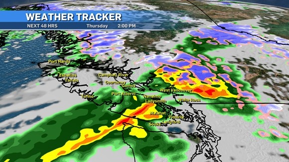
AR number one arrives Thursday. It will start on the northern tip of the island and continue to move south through the day.
For Greater Victoria, residents can expect the activity to pick up in the later hours of the morning with rain intensity increasing in the afternoon. We're looking at a range of 10 to 15 millimetres through the day.
As things taper down Friday morning, we can enjoy a break before AR two. The second atmospheric river will start to move into the island region later Saturday.
The timing of this second AR is a little less exact but CTV's Warren Dean is expecting rain to pick up late Saturday night for the southern island areas and roll through Sunday.
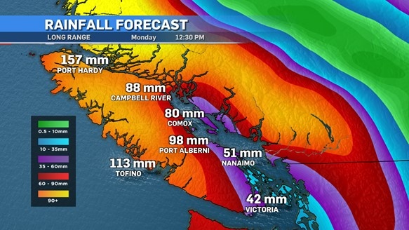
We can expect a bit more rain with this second storm as Greater Victoria will be in the 15 to 20 millimetre range. Totals around the island will be anywhere from 50 to 150 millimetres by the end of the weekend.
 (CTV News)
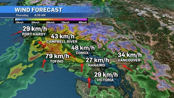
Let's not forget with these systems that wind will be a factor, which causes its own set of potential dangers.
Trees haven't had it easy over the last couple of summers and may not be as firmly sitting in the ground as they once were. With strong gusts over the course of these two storms, trees could easily topple in some areas.
 (CTV News)
As per usual, downed branches could also be a risk, as well as blocked drains in urban areas due to leaves and other object blocking them. Power outages may also occur.
There is some good news on the forecast, however. Halloween is looking decent for the kids as showers should be contained to the earlier morning hours making for a nice afternoon and evening.
Shopping Trends
The Shopping Trends team is independent of the journalists at CTV News. We may earn a commission when you use our links to shop. Read about us.


CTVNews.ca Top Stories

Ministers Joly, LeBlanc travel to Florida to meet with Trump's team
Two members of Prime Minister Justin Trudeau's cabinet will be in Palm Beach, Fla., Friday to meet with members of Donald Trump's team.
India alleges widespread trafficking of international students through Canada to U.S.
Indian law enforcement agencies say they are investigating alleged links between dozens of colleges in Canada and two 'entities' in Mumbai accused of illegally ferrying students across the Canada-United States border.
Teen actor Hudson Meek, who appeared in 'Baby Driver,' dies after falling from moving vehicle
Hudson Meek, the 16-year-old actor who appeared in 'Baby Driver,' died last week after falling from a moving vehicle in Vestavia Hills, Alabama, according to CNN affiliate WVTM.
Pizza deliverer in Florida charged with stabbing pregnant woman at motel after tip dispute
A pizza deliverer in central Florida has been charged with pushing her way into a motel room with an accomplice and stabbing a pregnant woman after a dispute over a tip, authorities said.
Christmas Eve stowaway caught on Delta airplane at Seattle airport
A stowaway was caught trying to nab a ride on a Delta Air Lines plane at Seattle-Tacoma International Airport on Christmas Eve.
2 minors, 2 adults critically injured in south Calgary crash; incident was preceded by a robbery
Multiple people were rushed to hospital, including two minors, in the aftermath of a serious vehicle collision on Thursday morning.
Cat food that caused bird-flu death of Oregon pet was distributed in B.C.: officials
Pet food contaminated with bird flu – which killed a house cat in Oregon – was distributed and sold in British Columbia, according to officials south of the border.
Aviation experts say Russia's air defence fire likely caused Azerbaijan plane crash as nation mourns
Aviation experts said Thursday that Russian air defence fire was likely responsible for the Azerbaijani plane crash the day before that killed 38 people and left all 29 survivors injured.
Unwanted gift card in your stocking? Don't let it go to waste
Gift cards can be a quick and easy present for those who don't know what to buy and offer the recipient a chance to pick out something nice for themselves, but sometimes they can still miss the mark.
Vancouver
-

B.C woman awarded nearly $750K in court case against contractor
A B.C. woman has been awarded nearly $750,000 in damages in a dispute with a contractor who strung her along for a year and a half and failed to complete a renovation, according to a recent court decision.
-
5 hospitalized after crash in Mission
Lougheed Highway is closed in Mission, B.C., after a car crash Thursday morning that sent five people to hospital.
-
These were the most-borrowed books from Vancouver libraries in 2024
What have Vancouverites been reading in 2024? The Vancouver Public Library has released its lineup of the books that kept flying off the shelf this year, which can serve as inspiration for bookworms’ 2025 reading lists.
Kelowna
-
B.C woman awarded nearly $750K in court case against contractor
A B.C. woman has been awarded nearly $750,000 in damages in a dispute with a contractor who strung her along for a year and a half and failed to complete a renovation, according to a recent court decision.
-
Forfeited Hells Angels clubhouse in Kelowna, B.C., sold to the city
A former Hells Angels clubhouse that was seized by the British Columbia government in 2023 after years of fighting in court has been sold to the City of Kelowna.
-
Death of woman found in Kelowna's Waterfront Park in June deemed 'non-criminal in nature': RCMP
Police in Kelowna say a death they began investigating back in June has now been confirmed as "non-criminal in nature."
Edmonton
-

Alberta premier hopes for health reform payoff in 2025, regrets deferring tax cut
"It may have been better for Albertans if we'd implemented and then found a way to be able to pay for it."
-
These are the scams that affected Albertans the most in 2024
CTV News Edmonton looks at the scams that affected Albertans the most in 2024, and how you can protect yourself.
-
Aviation experts say Russia's air defence fire likely caused Azerbaijan plane crash as nation mourns
Aviation experts said Thursday that Russian air defence fire was likely responsible for the Azerbaijani plane crash the day before that killed 38 people and left all 29 survivors injured.
Calgary
-

2 minors, 2 adults critically injured in south Calgary crash; incident was preceded by a robbery
Multiple people were rushed to hospital, including two minors, in the aftermath of a serious vehicle collision on Thursday morning.
-
Boxing Day draws deal-seekers, but maybe fewer than in times past
Calgarians hoping to save some money—or get that last gift they missed out on for Christmas—headed to the store for Boxing Day.
-
Boxing Day in Canada: Small retailers fear big shopping day won't make up for tough year
It’s one of the busiest shopping days of the year: Boxing Day sees thousands of people head to malls and big box stores to find great deals. But it's not so simple for smaller shops.
Lethbridge
-

Lake Louise ice climber takes a scary fall, then carries on climbing ice
The sport of ice climbing is becoming more and more popular, but one man is lucky to be alive after a serious fall in Alberta’s back country.
-
Safety tips for holiday home cooks: Lethbridge Fire and Emergency Services
If you’re planning to cook over the holidays, Lethbridge Fire and Emergency Services is reminding everyone to do it safely.
-
Here’s which bins your Christmas wrapping, ribbons and leftovers should go into
With piles of presents unwrapped Wednesday, Environment Lethbridge is reminding everyone to dispose of all that waste properly.
Winnipeg
-

16-year-old boy found with machete: Police
A 16-year-old boy is in custody after police said they found him with a machete.
-
Boxing Day in Canada: Small retailers fear big shopping day won't make up for tough year
It’s one of the busiest shopping days of the year: Boxing Day sees thousands of people head to malls and big box stores to find great deals. But it's not so simple for smaller shops.
-
Have you seen Davis? Winnipeg police search for missing man
Winnipeg police are asking the public to help find a man who went missing last week.
Regina
-

Yorkton RCMP seek tips to locate unlawfully-at-large inmate
Yorkton RCMP is seeking tips from the public to locate an inmate after staff noticed he was not present at the Whitespruce Provincial Training Centre.
-
Pedestrian collision sends man to hospital with life-threatening injuries
One man has been sent to hospital with life-threatening injuries after he was struck by a vehicle in the early hours of Wednesday in Regina.
-
Raised in Sask. after his family fled Hungary, this man spent decades spying on communists for the RCMP
As a Communist Party member in Calgary in the early 1940s, Frank Hadesbeck performed clerical work at the party office, printed leaflets and sold books.
Saskatoon
-
Raised in Sask. after his family fled Hungary, this man spent decades spying on communists for the RCMP
As a Communist Party member in Calgary in the early 1940s, Frank Hadesbeck performed clerical work at the party office, printed leaflets and sold books.
-
IN PICTURES: CTV Saskatoon viewers send us their holiday photos
A living gallery of viewer-submitted photos from the holiday season. Share your pictures with us at SaskatoonNews@bellmedia.ca
-
Sask. highway closed following serious collision
The Saskatchewan RCMP are investigating a serious collision on Highway 7, approximately 15 kilometres west of Rosetown.
Toronto
-

OPP shut down Hwy. 401 off-ramp clogged with Boxing Day deal-hunters
A Highway 401 off-ramp west of Toronto became so clogged up with Boxing Day deal-hunters Thursday that police had to shut it down.
-
Pedestrian seriously injured after being struck by driver of vehicle in North York
A pedestrian has been seriously injured after being hit by the driver of a vehicle in North York late Thursday afternoon.
-
Man wanted for 2 unprovoked incidents in downtown Toronto on Christmas Eve
Toronto police are searching for a suspect who allegedly choked a female in downtown Toronto then threatened an employee at a business with a hammer.
Montreal
-
 WEATHER
WEATHER Smog warning in effect in Montreal, Laval
Residents of Montreal, Laval and other regions are advised that a smog warning is in effect.
-
Mount Royal Cross turns 100
The cross on Mount Royal is celebrating a milestone, it turns 100. It was first lit up on Christmas Eve 1924 and continues to attract visitors today.
-
Experts warn shoppers to be cautious of online scams this Boxing Day
Cybersecurity experts are warning shoppers to pay close attention to online scams during Boxing Day. Jacques Sauve, a cybersecurity consultant for Trilogiam says scammers will send out fake emails and text messages.
Ottawa
-

Police identify victim of Christmas Day homicide in Hintonburg, charge suspect
The Ottawa Police Service says the victim who had been killed on Christmas Day in Hintonburg has been identified.
-
World Junior Championship to create a buzz in Ottawa this Boxing Day
A Canadian hockey holiday tradition returns to the capital this Boxing Day, as the 2025 World Junior Championship is set to create a buzz in the city.
-
What's open and closed in Ottawa over the holidays
CTVNewsOttawa.ca takes a look at what's open and closed over the Christmas and New Year's holidays this year.
Atlantic
-

Christmas Day fire causes heavy damage to building in Saint John, N.B.
A fire caused a power outage for around 900 residents of Saint John, N.B., Wednesday afternoon.
-
Civil War sword with N.B. ties now on display at Loyalist House
The blade of Dr. John F. Stevenson, who was born in Saint Andrews, N.B., is now part of the New Brunswick Historical Society’s collection after being purchased from a collector for $6,200 dollars.
-
Temporary overnight parking ban for Saint John, N.B.
Saint John, N.B., has declared an overnight parking ban for the South/Central Peninsula beginning 11 p.m. Thursday evening through 7 a.m. Friday morning.
London
-

Palace Theatre boarded up over the holidays due to recent damage
A break in, theft, and continued property damage has led to the boarding up of the Palace Theatre over the Christmas holidays.
-
Knights stars ready to help Canada chase gold at World Juniors
Three London Knights are on the roster, including Easton Cowan, who scored a hat-trick in Canada’s first exhibition game.
-
London fire responds to Wellington Road collision, contains fuel leak
London Fire Department was on the scene of a two vehicle collision involving a delivery truck on Tuesday morning.
Kitchener
-

Fire rips through former Peter Hay Knife Company building in Cambridge
Emergency responders were called to a fire in Cambridge on Thursday as flames ripped through the building that formerly belonged to the Peter Hay Knife Company.
-
Sawed-off shotgun and three knives seized during Cambridge arrest
Two people from Thunder Bay are facing drug trafficking and weapons charges after they were arrested in Cambridge.
-
Baden-born player, Guelph Storm forward and former Kitchener Ranger prepare to hit the ice at World Juniors
Waterloo Region and Guelph will be well represented as the International Ice Hockey Federation World Juniors gets underway.
Northern Ontario
-

Drug trade fuelling increase in gun crime in Timmins, police say
Police in Timmins say gun crime is increasing in the city because of the drug trade, especially involving opioids.
-
Freezing drizzle advisory in effect for Greater Sudbury
Environment Canada issued a freezing drizzle advisory Thursday for areas in and around Greater Sudbury.
-
Average home sale prices in the Sault set new record last month
Homes sales edged upward in many markets in northern Ontario last month, including Sault Ste. Marie, where average sale prices set a new record.
N.L.
-

Her son needed help with addiction. Instead, he's spending Christmas in N.L. jail.
As Gwen Perry prepares for a Christmas without contact from her son, who is locked inside a notorious St. John's, N.L., jail, she wants people to understand that many inmates need help, not incarceration.
-
A massive, menacing Steller's sea eagle is dazzling birders in a Newfoundland park
A national park in Newfoundland has made the unusual move of opening in the winter so people can catch a glimpse of its rare and menacing new guest.
-
Newfoundland woman washed sick patients' hair every Saturday for more than 20 years
A retired nurse and teacher in Newfoundland was honoured this week for her volunteer work, which included more than two decades washing the hair of bedridden hospital patients.