What's in store for summer weather on Vancouver Island?
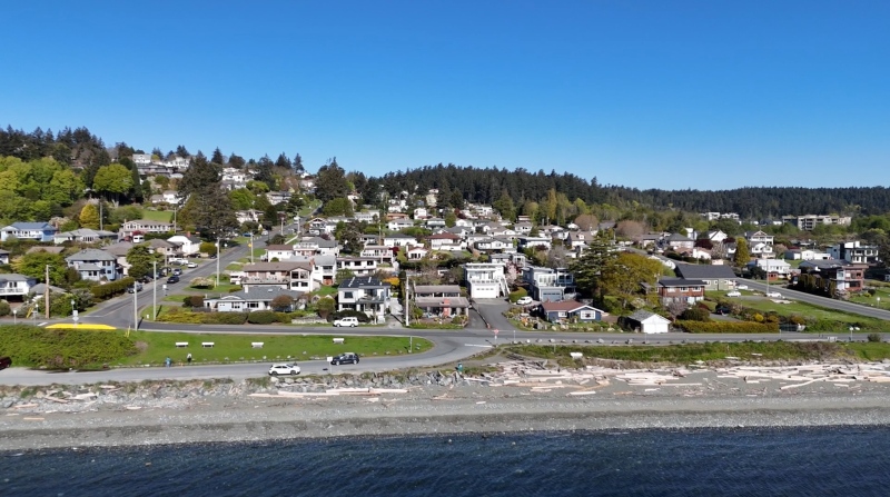
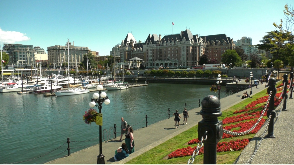 The Victoria Inner Harbor is pictured: (CTV News)
The arrival of June brings on the start of summer. So what can we expect for summer 2023? We’ll get to that in a minute.
First, let’s look back to spring, and more specifically the month of May. While it felt at times we were still stuck in winter mode, the month we just left broke that feeling in a big way.
March and April were pretty normal for the most part, although we didn’t get as much moisture as we would’ve liked. As we ended our third year with La Nina, the weather pattern held much of the big moisture to the south and gave heavy rain and bigger snow packs to California and Nevada. Here in the Pacific Northwest, we received what was left, meaning less moisture.
There were little bumps in temperature during the spring also. We had a record-setting weekend in the middle of March and we were able to determine that this year an El Nino would be building into the summer.
April was mostly typical, but as we started getting into the month of May we started seeing warmer temperatures – not just here on Vancouver Island, but across Western Canada and into parts of Ontario and Quebec.
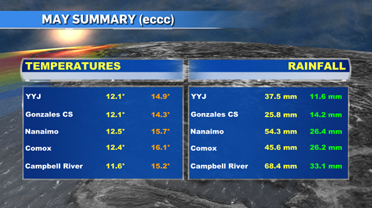
Now that May has come and gone, we can see what it did deliver weather wise. Here on the island we had the warmest May recorded. Two weather stations in Greater Victoria – the airport and Gonzales – along with stations in Nanaimo, Comox and Campbell River were all number one for heat since they started tracking data. Our mean temperatures were 2 to 4 degrees warmer throughout much of the province and with that we saw 279 extreme daytime highs and 22 precipitation records during May.
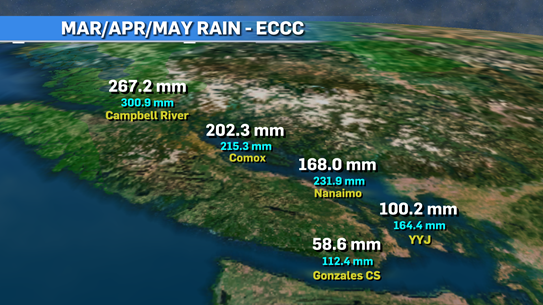
If you look at the precipitation numbers from meteorological spring (March/April/May), we can see we are lagging behind and the farther south you go, the bigger the lag is. With lower moisture numbers, we’re already preparing for a very dry summer.
As we look ahead to summer, we have already established that it’s an El Nino year and it will get stronger the deeper as we get into the year.
We’re seeing both the Pacific and Atlantic oceans warming up at a faster pace than normal and numbers seem to be approx. 1-3 degrees warmer on average.
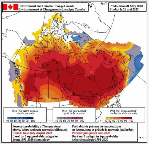
We're expecting a hotter than average summer throughout B.C. and rain seems to be lacking also.
That’s not saying we’re going to see weeks and weeks of temperatures in the 30s and 40s but it will be warmer and drier than usual and at a few points we’ll deal with heat waves and probable drought conditions through many areas.
It’s important we pay attention to the dry conditions as the risk of wildfires will be high this year. We’ve already been dealing with bad situations throughout the country.
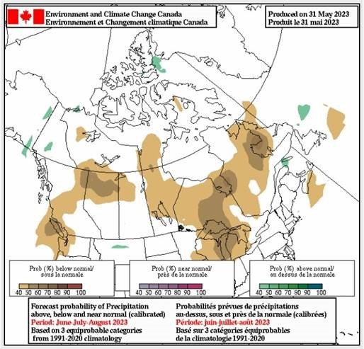
Best case scenario is we get a run of sunshine and warm days followed by some moisture to keep things fresh. And just like your summer song this year, hopefully it stays on repeat. Of course, we know that weather doesn’t do what we want. It does what it wants and we just have to deal with it the best we can.
CTVNews.ca Top Stories

Young people 'tortured' if stolen vehicle operations fail, Montreal police tell MPs
One day after a Montreal police officer fired gunshots at a suspect in a stolen vehicle, senior officers were telling parliamentarians that organized crime groups are recruiting people as young as 15 in the city to steal cars so that they can be shipped overseas.
Man sets self on fire outside New York court where Trump trial underway
A man set himself on fire on Friday outside the New York courthouse where Donald Trump's historic hush-money trial was taking place as jury selection wrapped up, but officials said he did not appear to have been targeting Trump.
Sask. father found guilty of withholding daughter to prevent her from getting COVID-19 vaccine
Michael Gordon Jackson, a Saskatchewan man accused of abducting his daughter to prevent her from getting a COVID-19 vaccine, has been found guilty for contravention of a custody order.
She set out to find a husband in a year. Then she matched with a guy on a dating app on the other side of the world
Scottish comedian Samantha Hannah was working on a comedy show about finding a husband when Toby Hunter came into her life. What happened next surprised them both.
Mandisa, Grammy award-winning 'American Idol' alum, dead at 47
Soulful gospel artist Mandisa, a Grammy-winning singer who got her start as a contestant on 'American Idol' in 2006, has died, according to a statement on her verified social media. She was 47.
Shivering for health: The myths and truths of ice baths explained
In a climate of social media-endorsed wellness rituals, plunging into cold water has promised to aid muscle recovery, enhance mental health and support immune system function. But the evidence of such benefits sits on thin ice, according to researchers.
'It could be catastrophic': Woman says natural supplement contained hidden painkiller drug
A Manitoba woman thought she found a miracle natural supplement, but said a hidden ingredient wreaked havoc on her health.
The Body Shop Canada explores sale as demand outpaces inventory: court filing
The Body Shop Canada is exploring a sale as it struggles to get its hands on enough inventory to keep up with "robust" sales after announcing it would file for creditor protection and close 33 stores.
Vicious attack on a dog ends with charges for northern Ont. suspect
Police in Sault Ste. Marie charged a 22-year-old man with animal cruelty following an attack on a dog Thursday morning.


