
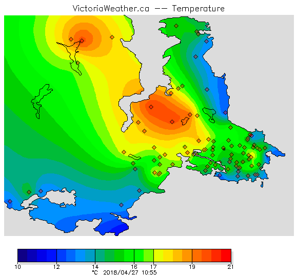
Sun worshippers like myself have gotten a real charge out of the sunny, warm weather this week!
Records fell all over Vancouver Island Thursday, the hottest day of the year so far.
|
Location |
New record |
Old record |
Records began |
|
Campbell River Area |
25.0 |
22.6 set in 2004 |
1958 |
|
Comox Area |
25.5 |
22.8 set in 1926 |
1914 |
|
Estevan Point |
20.4 |
17.2 set in 1947 |
1908 |
|
Gonzales Point Area |
24.4 |
23.0 set in 2004 |
1874 |
|
Malahat Area |
22.9 |
22.0 set in 2004 |
1986 |
|
Nanaimo Area |
25.0 |
24.4 set in 1926 |
1892 |
|
Port Hardy Area |
20.3 |
19.4 set in 1947 |
1944 |
|
Powell River Area |
23.7 |
22.2 set in 1971 |
1924 |
|
Victoria Area |
24.0 |
23.3 set in 1941 |
1914 |
Source: Environment and Climate Change Canada
Temperatures peaked late Thursday afternoon after a week of progressively warmer weather; the summer-like heat attributed to a ridge of high pressure and thermal trough set up over southern of B.C.
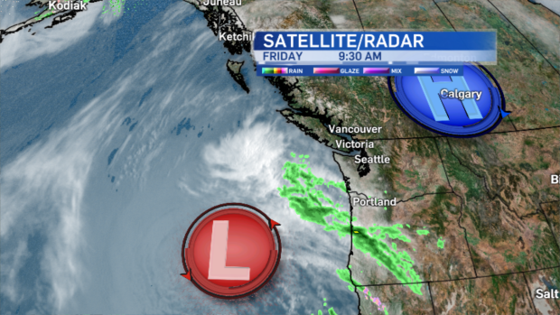
While Friday is still pleasant on the island, the ridge and thermal trough are tracking eastward; an increase in onshore flow allows for cooler marine air to return. Already, morning temperatures are cooler at the waterfront, compared to previous mornings this week.'
Stratus clouds will also move onshore this afternoon. Moral of this story today is to have lunch outside and enjoy the warm weather while it’s here because tomorrow, we’re going to get some rain again.
A low pressure system moving slowly from the southwest arrives in the wee hours of Saturday morning, spreading showers and periods of rain over southern Vancouver Island.
Throughout the day the chance of showers increases for areas north of the Capital Region up to about Sayward.
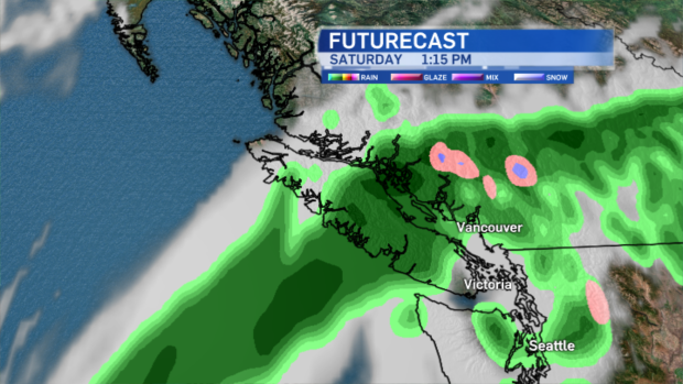
Unlike the south island, the north island may escape with just a sprinkle or two this weekend!
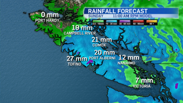
Temperatures will be dramatically cooler than the hot days we’ve just gotten used to (although they’ll actually be closer to seasonal average). Showers continue on Sunday and may linger through early Monday.
But there is some good news on the horizon. Another ridge of high pressure is expected to build early next week. That means temperatures will warm up again and weather will be dry, and there’s potential for another warm-to-hot spell Wednesday and Thursday next week.


