
VICTORIA -- A first-of-its-kind partnership is being forged in the waters off Vancouver Island.
A federal agency, which conducts extensive 3D mapping of the ocean floor, is handing over 3D scans to salvage organizations.
"We are talking ocean restoration here,” said John Roe with the Dead Boats Society.
The organization has worked for years to clean the ocean bottom of sunken vessels and garbage near Victoria and the Southern Gulf Islands.
“We have been here for about 125 years and now we have to start fixing it.”
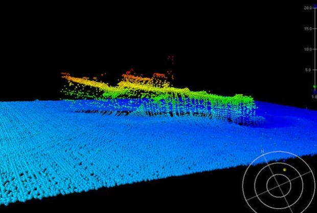
The Canadian Hydrographic Service is tasked with keeping shipping lanes safe, but also uses its technology to identify hidden shipwrecks.
"It’s just like draining the bathtub," Mark LeBlanc, with the hydrographic service, told CTV Vancouver Island. "You get a full view of the ocean bottom.”
Boats are equipped with high-end imaging systems, which can not only take a detailed image of sunken relics, but show them in three dimensions.
"Picture taking your fish finder on your recreation vehicle and add a million of those together,” said LeBlanc.
The federal agency has been mapping the Pacific coast of Canada for years, but for the first time it will hand over some of their imaging to conservation groups like the Dead Boats Society.
"With this partnership with Mark it will greatly shorten the time span of us finding the problems," said Roe.
The society had previously had surfaced roughly 60 vessels off the island, but largely relied on checking Google Maps to see where vessels had sunk.
The salvage organization says access to the federal images will mean more environmentally damaging wrecks will be pulled from the water.


