ADVERTISEMENT
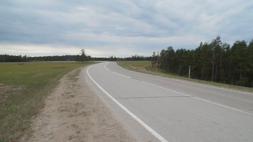
These are some of the most dangerous roads in the world
From hairpin turns to extreme fog and deadly rockslides, fasten your seatbelts as CTVNews.ca takes a look at some of the most dangerous roads around the world.
Updated:
Published:
Image 0 of 50

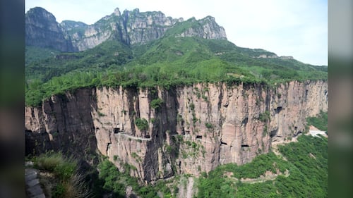
Location: China
Dangers: 30 windows of various sizes and shapes, no guardrails, rockfalls and extreme fog
Located in the northwest of Henan province in China, Guoliang Tunnel is an extremely scenic route, but also terrifyingly dangerous.
(Feature China/Future Publishing via Getty Images)
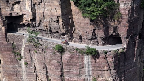
The tunnel is known for being a 'road that does not tolerate mistakes.' Even one wrong manoeuvre could be dire, as the road only spares a few feet on either side as you pass through the tunnel.
(Feature China/Future Publishing via Getty Images)
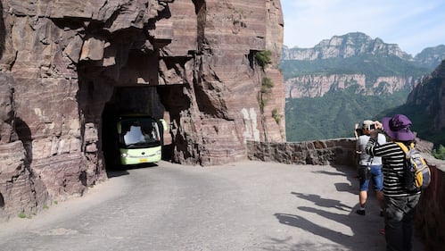
The tunnel was built by hand by village locals from 1972 to 1977, and opened on May 1, 1977. Before its construction, the only access to the village of Guoliang was narrow steps carved in the mountainside known as the 'Sky Ladder.'
The 1,250-metre-long, four-metre-wide tunnel has 35 windows along it.
A view of Guoliang Tunnel Road, dug without power tools in the 1970s by villagers, on May 18, 2017 in Huixian, China. (Feature China/Future Publishing via Getty Images)
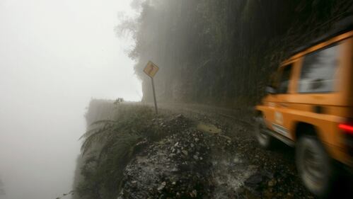
Location: Bolivia
Dangers: Fog, cascades, steep slopes, hairpin turns
North Yungas Road, also known as the 'Death Road,' is the main route linking the town of La Paz -- the capital of Bolivia -- with the town of Coroico, and features more than 200 hairpin turns.
(Spencer Platt/Getty Images)
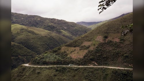
It is also usually covered in thick fog and dust in the summer, making it difficult for motorists to see what's in front of them. The region also experiences year-round rainfall, which keeps the road wet and slippery at all times.
(Spencer Platt/Getty Images)
Built in the 1930s by Paraguayan prisoners during the Chaco War, North Yungas Road caused nearly 300 deaths every year up until 1994. It was modernized over a 20-year period ending in 2006. The new road features widened lanes, paved roads and guardrails.
Top view of the winding ‘death road’. (AIZAR RALDES/AFP via Getty Images)
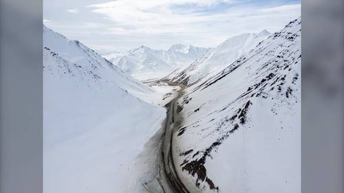
Location: India
Dangers: Narrow, no guardrails, extreme weather, landslides
Known for having one of the most treacherous drives in the world, Zoji La, also known as the Zojila Pass, is a high mountain pass in the Himalayas. Vehicles move near the Zojila mountain pass in Ganderbal, Jammu and Kashmir, India, on July 24, 202. (Nasir Kachroo/NurPhoto via Getty Images)
Landslides are a frequent problem on this road, and with it's zig-zags and an altitude of approximately 3,528 metres above sea level, a wrong turn could be fatal.
(Yawar Nazir/Getty Images)
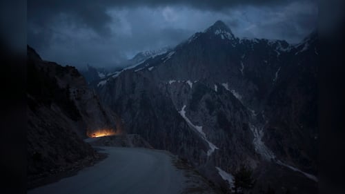
This road is closed during the winters due to heavy snowfall. It was constructed in 1947 and used for military purposes.
(AP Photo/Tsering Topgyal)
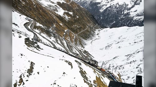
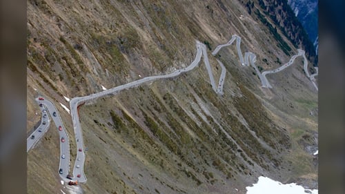
Location: Italian Alps (Italy-Switzerland border)
Dangers: 75 hairpin bends
Described as the 'roof of Italy,' the Stelvio Pass is one of the world's most terrifying roads. With challenging driving conditions, it sits at an elevation of 2,757 metres above sea level.
(Marco Alpozzi/LaPresse via AP)
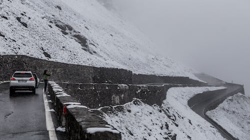
Heavy snowfall in the winter months renders this road impassable and it is typically shut down in early fall and opens up again in the later months of spring.
A photo shows the winding roads of Stelvio Pass, on the mountainside of the Autonomous Region of Trentino-Alto Adige, Italy on May 28, 2022. (Andrea Carrubba/Anadolu Agency via Getty Images)
Construction of the Stelvio Pass began after the end of the Napoleonic Wars in 1815. It took 2,500 builders five years to complete it.
During the First World War, Austria-Hungary and Italy battled near the pass, but the Swiss, who were nearby and fearing they would be hit by stray bullets, had both sides come to an agreement that they would only shoot into the valleys.
(LUK BENIES/AFP via Getty Images)
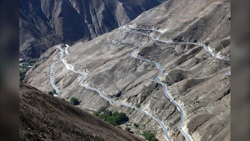
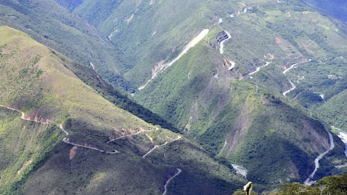
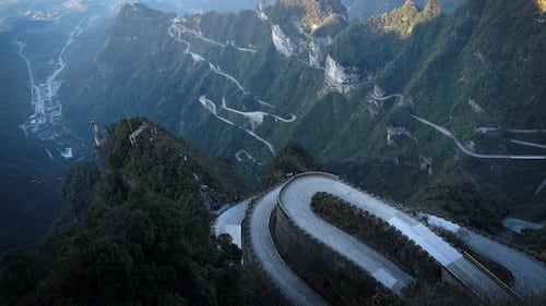
Location: China and Tibet
Dangers: 99 hairpin bends, prone to frequent earthquakes, mudslides, rockslides, avalanches
This stretch of the Sichuan-Tibet Highway, also known as '72-turnings of Sky Road,' is considered one of the world's most deadly roads and the most treacherous section on the Sichuan-Tibet line.
(Wang Jianfeng/VCG via Getty Images)

The road is 4,652 metres above sea level and 46 kilometres long. Motorists can experience the changes of the four seasons in a day, along with altitude sickness.
A view of 'Nu Jiang 72 Turns,' sections of the winding road along the Sichuan-Tibet Highway, on June 5, 2023 in Changdu City, Tibet Autonomous Region of China. (Wang Jianfeng/VCG via Getty Images)

(Wang Jianfeng/VCG via Getty Images)

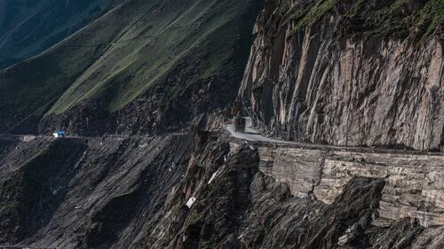
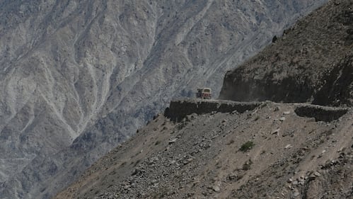
Location: Between Pakistan and China
Dangers: Landslides, falling rocks, high altitudes
The Karakoram Highway is a 1,300-km-long stretch of road connecting China to Pakistan and is occasionally referred to as the 'Eighth Wonder of the World'.
(Robert Holmes/CORBIS/Corbis via Getty Images)
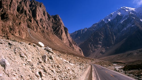
One of the highest paved roads in the world, motorists can take in breathtaking scenes featuring glacial waterfalls, alpine lakes and snow-capped peaks.
(History/Universal Images Group via Getty Images)

(Robert Holmes/CORBIS/Corbis via Getty Images)
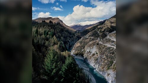
Location: New Zealand
Dangers: Narrow roads, unpaved roads, no guardrails, cliffs
Skippers Canyon Road is one of the most scenic roads in the world but also one of the deadliest, being that it is extremely narrow and difficult to manoeuvre.
(Ben Davies/LightRocket via Getty Images)
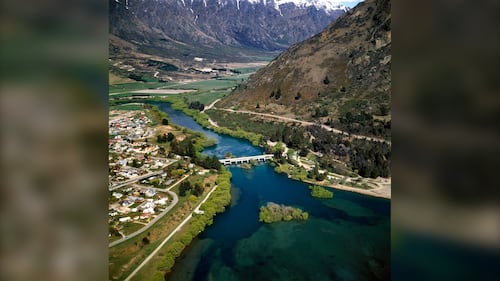
At 17.4 kilometres long, it is mostly one-way and with no guardrails, there is very little room for error. It is most often used by tour buses and adventure firms.
(Ben Davies/LightRocket via Getty Images)
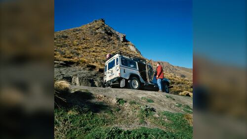
The road was hand-carved into the side of a cliff by miners in the late 1800s and took seven years complete.
Many sections of the road remain the same since the day it opened to the public in 1890. The road is said to be so dangerous that rental car companies won't honour the insurance if you drive on it.
(Ben Davies/LightRocket via Getty Images)
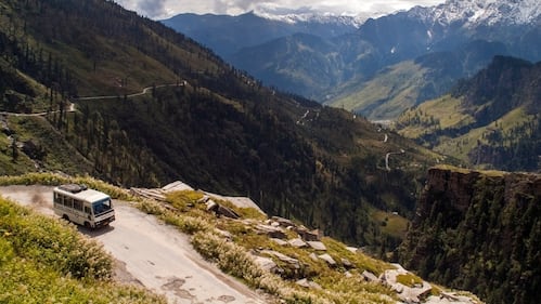
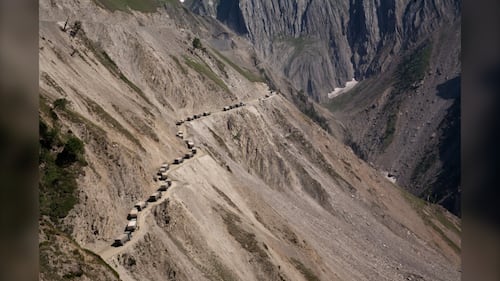
Location: India
Dangers: Traffic congestion, landslides, blizzards, avalanches
Rohtang Pass is one of the highest and most dangerous roads in India.
With winding bends, no barriers and rockfalls, it makes the commute a treacherous one for most travellers.
(Leisa Tyler/LightRocket via Getty Images)

Although dangerous, the Rohtang Pass offers some of the world's most stunning mountain views and wildflowers. It is only open from May to November due to changing weather conditions.
(Bhaswaran Bhattacharya/IndiaPictures/Universal Images Group via Getty Images)
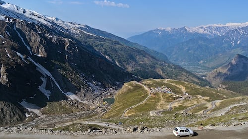
The road also encounters heavy traffic jams and is covered with thick snow and slush. Adding to the dangers, it is often covered in heavy fog for most of the year. It has also seen more accidents than any other road in India.
(Getty Images)
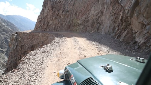
Location: Pakistan
Dangers:Unpaved gravel roads, no barriers, no guardrails, landslides, high altitude, narrow turns Fairy Meadows Road in Pakistan is considered one of the most dangerous roads in the world because of it's high altitude and unstable, narrow mountain paths, which are approximately the width of a Jeep Wrangler in both directions. Most of the drive is composed of very steep sections. The twists and turns last for approximately 16 kms and take close to 2 hours to navigate.
(Muhammed Semih Ugurlu/Anadolu Agency via Getty Images)
The road was built by villagers hundreds of years ago and has never been serviced or repaired since. It is closed in the winter and is accessible only in summer.
Because this all-gravel road is so dangerous, it is only allowed to be driven by locals.
(Muhammed Semih Ugurlu/Anadolu Agency via Getty Images)
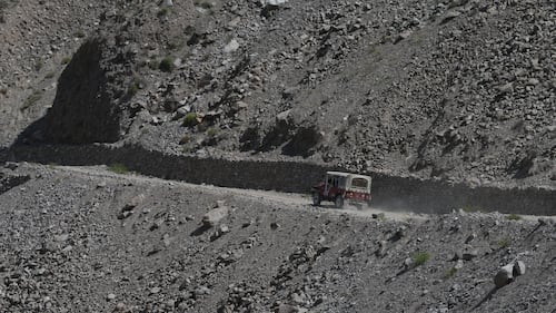
The road's name was given by mountaineers who came to climb the region's high mountains during the 1950s. (Muhammed Semih Ugurlu/Anadolu Agency via Getty Images)
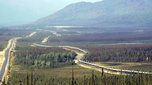
Location: Alaska
Dangers:Extreme cold, vast emptiness and flying gravel from trucks carrying supplies.
The Dalton Highway -- also known as 'Haul Road' -- was built in 1974 to facilitate the Trans-Alaska Pipeline, which runs parallel to the road and is used by many truckers.
The trans-Alaska pipeline is seen next to the Dalton Highway north of Fairbanks, Alaska, Aug 10, 2005. (AP Photo/Al Grillo)

The Dalton Highway (Alaska Route 11) stretches approximately 666 kilometres across northern Alaska, and through the Arctic Circle, from Livengood to Prudhoe Bay, with only three small towns along the way.
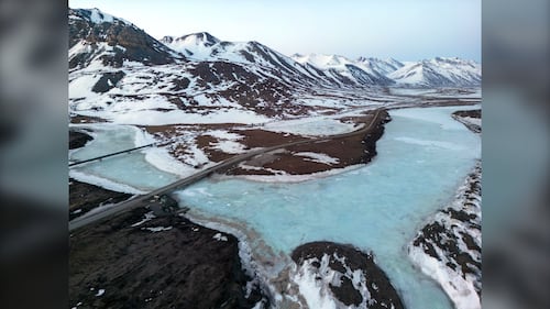
An aerial view of the Dalton Highway, a portion of the Trans Alaska Pipeline System (TAPS), and the frozen Atigun River during the early morning hours of May 9, 2025 about 22 miles north of Atigun Pass in North Slope Borough, Alaska. (Lance King/Getty Images)
Travellers on this highway should be aware of changing road conditions due to weather, and the road itself, which is partly made with gravel.
An aerial view of the Dalton Highway on May 10, 2025 at Atigun Pass in the Brooks Range area of North Slope Borough, Alaska. (Lance King/Getty Images)
An aerial view of the Dalton Highway and a portion of the Trans Alaska Pipeline System (TAPS) crossing over the frozen Atigun River during the early morning hours of May 9, 2025 about 22 miles north of Atigun Pass in North Slope Borough, Alaska. (Lance King/Getty Images)
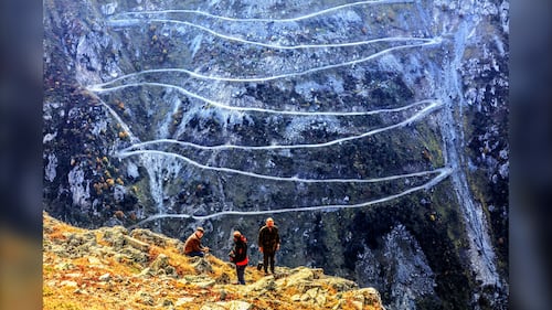
Location: Turkiye
Dangers: Turkiye’s state road D915 has no guardrails and includes 29 steep hairpins.
The road is 179 kilometres long, with an elevation of 6.677 feet above sea level, and crosses the Pontic mountains.
People are seen near the Bayburt D915 crooked highway on Soganli mountainside during the autumn season at the Caykara Karacam neighbourhood in Trabzon, Turkiye on Oct. 20, 2017. (Ali Ihsan Ozturk/Anadolu Agency/Getty Images)
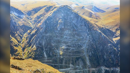
It was built in 1916 by Russian soldiers, and is considered one of the most dangerous roads in the world. Bayburt D915 crooked highway is seen on Soganli mountainside during the autumn season at the Caykara Karacam neighbourhood in Trabzon, Turkey on October 20, 2017. (Ali Ihsan Ozturk/Anadolu Agency/Getty Images)
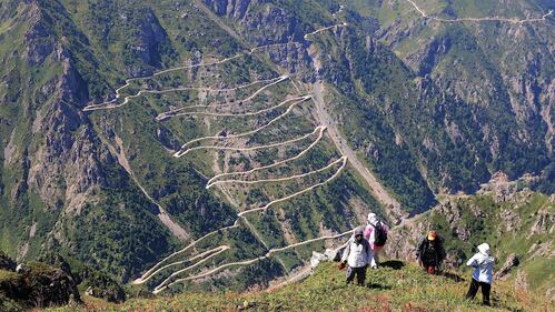
This area has emerged as a new route known for its stunning landscapes and has become a favourite destination for nature and adrenaline enthusiasts, captivating visitors with its natural beauty.
The Derebasi Hairpin Turns attracts thousands of adventure seekers, photographers, and nature lovers every year, located on the steep slopes of Soganli Mountain at an altitude of 3,500 meters between Bayburt and Trabzon, on August 30, 2025. (Besir Kelleci/Anadolu via Getty Images)
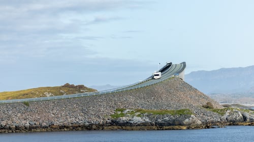
Location: Norway
Dangers: Sharp turns and towering waves that crash over the roadway during storms.
The Atlantic Ocean Road, called Atlanterhavsveien in Norwegian, is a scenic 8.3-kilometre route along the country’s coastline that first opened in 1989.
A view of the Atlantic Ocean Road, Norway on September 18, 2024. (Manuel Romano/NurPhoto via Getty Images)
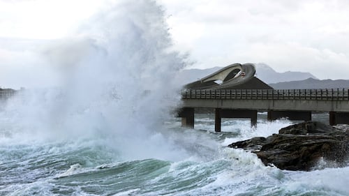
The road features iconic bridges that connect islands and offers spectacular views of wild nature.
A picture taken on November 26, 2011 shows a giant wave over the Atlantic Road in Averøy, Norway as the storm "Berit" struck the Norwegian coast. (BERIT ROALD/AFP via Getty Images)

A drone view of the Atlantic Ocean Road in Norway on Sept. 18, 2024. (Manuel Romano/NurPhoto via Getty Images)
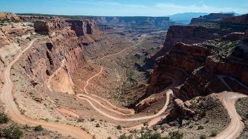
Location: Utah
Dangers:The mostly unpaved and narrow road requires extreme caution as only one vehicle can pass in some areas, and drivers should watch out for low overhanging rocks.
The Shafer Trail winds 457 metres down colourful sandstone walls. (National Park Service)

The 31.06 kilometre-long road requires a high-clearance 4WD vehicle to traverse steep sections of this backcountry route.
The view from the Shafer Canyon Overlook towards La Sal mountains in Canyonlands National Park in Utah. (Andrew Lloyd/Loop Images/Universal Images Group via Getty Images)
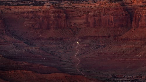
According to National Park Service, Shafer Trail is named after the Shafer family, Mormon pioneer settlers, who started the trial in 1916 to move cattle.
The Shafer Canyon dirt road is viewed at sunrise on October 7, 2023 near Moab, Utah. (George Rose/Getty Images)
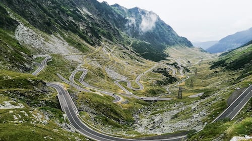
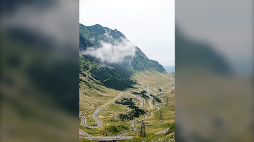
Location: Romania
Dangers:The winding road features steep hairpin turns and sharp descents. It is usually closed from November-June due to heavy snow.
(Giovanni Mereghetti/UCG/Universal Images Group via Getty Images)
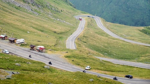
The was mountain road crossing was built between 1970 and 1974 in response to a Soviet invasion of Czechoslovakia in 1968. It reaches an altitude of 2,042 metres and has more tunnels than any other road in the country.
Giovanni Mereghetti/UCG/Universal Images Group via Getty Images)
(Giovanni Mereghetti/UCG/Universal Images Group via Getty Images)
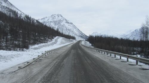
Location: Siberia, Russia
Dangers:Extremely remote road located in Russia’s far east, and the only one in the area. It is mostly unpaved and is dangerous and nearly impassable in rainy weather.
Rosavtodor.ru.
Thousands of people -- including political prisoners and convicts -- are said to have died building Siberia’s road to Yakutsk, which started in 1932 and took 20 years to construct. Their bodies were allegedly buried in the road’s foundations, which led to its nickname, “Road of Bones.”
A paved section of Kolyma Highway R504 at Tyungyulyu Village, Jan. 10, 2013. (Svetlana Ivanova/WikiMedia Commons)
The 2,000 kilometre route to the Siberian city of Yakutsk is the coldest in the world with a risk of death due to the treacherous conditions.
This aerial view shows the bumpy landscape of mounds and hollows formed by thawing permafrost, known as "bylars" in the Yakut language, in the settlement of Churapcha, around 135 kilometres from the eastern Siberian city of Yakutsk, on March 29, 2025. (EKATERINA ANISIMOVA/AFP via Getty Images)
Location: China
Dangers:This road has 99 sharp turns and reaches 1,300 metres above sea level. Too scared to drive it? You can climb 999 stairs leading to the peak of Tianmen Mountain instead.
Tianmen mountain in Zhangjiajie, China's Hunan province, Nov. 12, 2020. (WANG ZHAO/AFP via Getty Images)
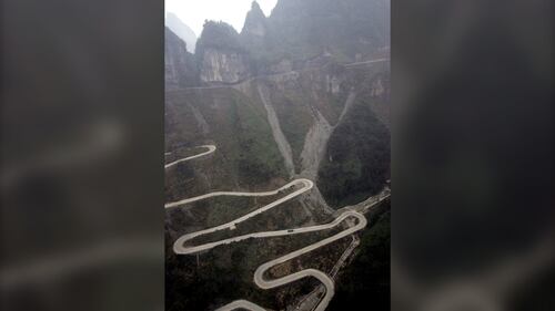
Construction began in 1998 and opened to the public in 2006. The 11-kilometre winding road spirals at the top of the route and features steep drops.
A bus makes its way up the winding road to the 1,528-meter-high Mount Tianmen at the Zhangjiajie National Forest Park on Dec. 13, 2005. (Photo by GOH Chai Hin / AFP via Getty Images)

Too scared to drive it? You can climb 999 stairs leading to the peak of Tianmen Mountain, or ride the Tianmen Mountain Cableway and check out the scenic views.
A cable car goes up to the peak of Tianmen Mountain on Dec. 11, 2005 at Zhangjiajie National Park in China's Central Hunan province. (Andrew Wong/Getty Images)