
The odds of forecasting snow for Victoria have dramatically decreased. It’s officially Spring! Well, astronomically speaking. Meteorologically, spring started March 1st.
Huh?
A quick explanation:
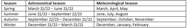
The weather we associate with certain seasons doesn’t really match up with astronomical seasons. For example, sometimes we’ll get hot summer-like temperatures in early June, even though the start of summer is still a few weeks away. Sometimes we’ll get snow in early December, even though the astronomical calendar says winter doesn’t start until December 21 or 22.
It’s also tricky to track trends when the number of days in a season fluctuates by a day or two. To align everything more accurately, climate scientists and meteorologists divide the year up into 3 month chunks based primarily on temperature.
Based on that, meteorologically, spring sprung a few weeks ago, although this time, it seems Mother Nature hung on to winter a little longer than most of us would have liked. This first week of astronomical spring is bringing us average temperatures and the expected unsettled weather complete with showers, sunny breaks, cloudy periods and occasional gusty winds.
Looking ahead, we’re in for fairly average conditions through Northern Hemispheric spring (March to May). We’ve come out of La Niña, which typically means cooler conditions with more precipitation for Vancouver Island. Now we’re holding in a neutral pattern. Summer and fall could transition back to El Nino.
The U.S National Weather Service’s Climate Prediction Center says “there are increasing odds for El Niño toward the second half of 2017 (50-55% chance from approximately July-December).” If that transition takes place, we could be enjoying warmer and drier conditions through the end of the year. I’ll keep you posted!


