
You know there’s a change in the weather coming when you see a halo around the sun.
CTV viewer Charlie Galan snapped this picture early this morning in Nanaimo. Halos often appear on days when there’s a thin layer of cirrus clouds in the sky. These clouds are made up of ice crystals, so, unlike rainbows in which raindrops refract light, halos appear when ice crystals do the work.
When cirrus clouds approach, it’s usually an indication that the weather is about to change (not for the better). Cirrus clouds form high up in the atmosphere and often are associated with an approaching front. The clouds themselves can indicate frontal lifting – a sign that rain is coming. Sure enough, we have rain on the way…but not yet, at least for most of Vancouver Island.
Gorgeous morning
You know it’s a nice day on the South Island whenTwitter blows up with pretty pictures!
Victoria
Morning #YYJ! �� pic.twitter.com/bPlcWcvazy
— Samantha Fex (@fexcreative) April 19, 2018
Gorgeous! It’s been a long, wet winter so days like this seem extra special! #Grateful #yyj pic.twitter.com/1DugfrYUBi
— Monique Gray Smith (@ltldrum) April 19, 2018
Beautiful morning in #yyj pic.twitter.com/lOClzQ27R1
— Jordan Ivey (@Chaka015) April 19, 2018
Nanaimo
Good Morning from the Island �� We're in for another stellar spring day in #Nanaimo on #VancouverIsland for a walk along our Seawall.
— Richard James Milne (@RickJamesMilne) April 19, 2018
Make it a Great Day �� #tourismNanaimo #tourismVancouverIsland #ExploreNanaimo #CameronIsland pic.twitter.com/ibwbNY4hmw
I hear that Spring has yet to ...well, spring forth in parts of our country. For those fighting snow and ice #Nanaimo #MaffeoSuttonPark pic.twitter.com/l5g5pv6kqy
— Smiling Dog Designs (@the_smilingdog) April 19, 2018
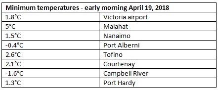
Waking up to mainly clear skies at this time of year often means a cool start to the day. Temperatures ranged from just below freezing to 5 degrees before sunrise:
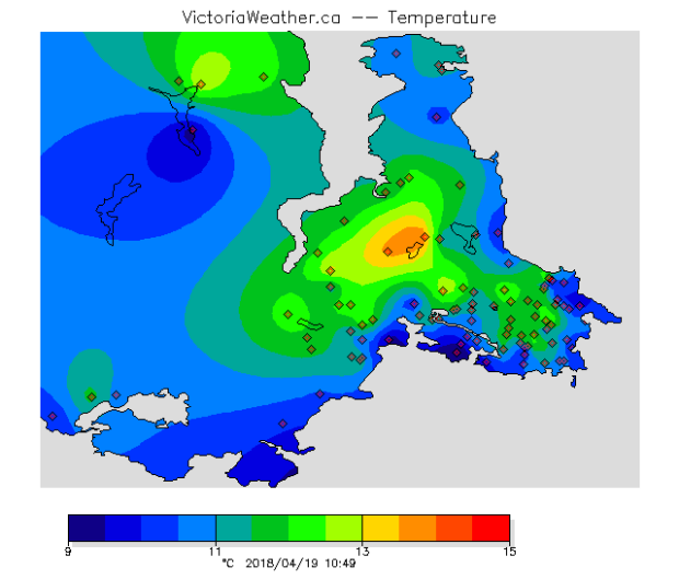
The warm up is underway in Greater Victoria. The School-Based Weather Station Network shows a few south island neighbourhoods with temperatures already the teens by mid-morning.
Temperatures today are expected to peak in the low to mid-teens on the island. Yay! I know I’m not the only person who’s pleased about this That said, it’s kind of short lived. Again. Clouds are increasing from the northwest today ahead of the next round of rain. It looks like it’ll take until late Friday afternoon for a showers to develop in the Greater Victoria area.
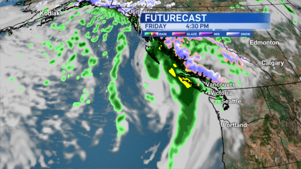
The blip on the radar clears as the weekend gets underway. Depending on where you are, Saturday may be breezy and there may still be some isolated showers in the wake of the front. Sunday is the turning point – back to calm, pleasant, springtime conditions and then, next week happens! Look at this…
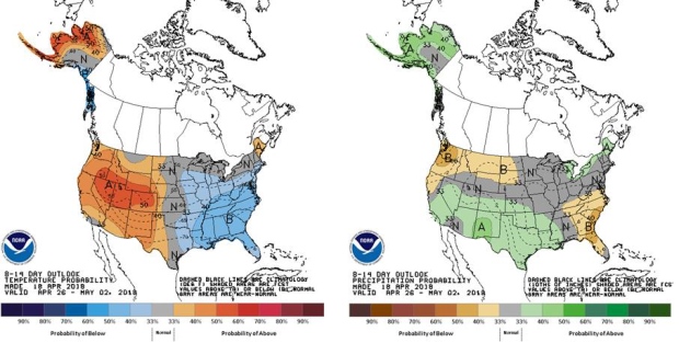
Computer models are in agreement that next week is fairly dry, sunny and warm with temperatures above seasonal average on Vancouver Island. You’re officially allowed to do a happy dance. I’m doing mine!


