
Today’s island weather story is about scorching temperatures and wildfire smoke.
Let’s start with air quality. It’s not good, and it’s about to get worse. Air quality is forecast to diminish this afternoon as smoke from the wildfires burning in the interior of our province continues to waft out to the coast. The trend is for smoke to be thicker late afternoon and evening, clearing a little in the morning.
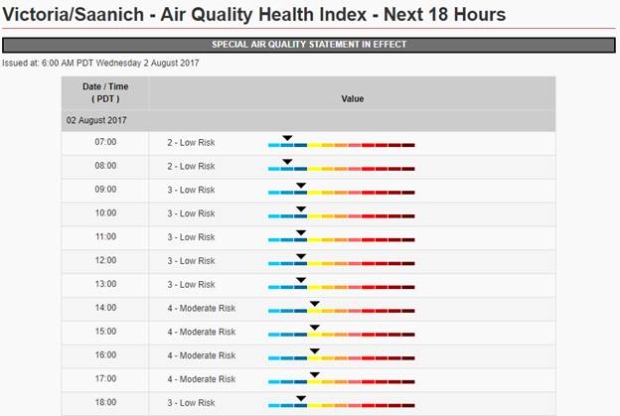
Here’s the Air Quality Health Index as of 6 a.m.:
More information on air quality and how to handle the conditions can be found at www.bcairquality.ca and www.airhealth.ca.
How long will the smoke last?
It looks like the hazy conditions will continue for another couple of days. Here’s the latest forecast from www.firesmoke.ca, showing the predicted smoke intensity, 1 a.m. August 2 to 2 a.m. August 4.
Wildfire smoke: The forecast wildcard
If we didn’t have smoke to deal with, the hot airmass over southern British Columbia associated with a massive upper ridge of high pressure would produce some intense record high temperatures, but when it comes to forecasting daytime highs this week, the smoke is the wildcard. Smoke in the atmosphere has the ability to block sunlight and prevent solar radiation from reaching the surface.
If it does that, it can lower daytime high temperatures. It’ll depend on how thick the smoke is and how long it lingers. So will we smash records under these conditions? We’re still expecting extreme heat on Vancouver island that could threaten temperature records today and tomorrow.
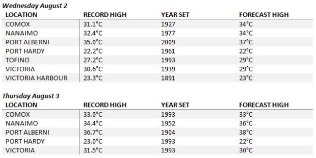
Port Alberni could experience it’s hottest day on record this week
For the stats fans out there, this is a good one. The all time record high for Port Alberni was 37.5°C set August 13, 2002. That means tomorrow could be the hottest days ever recorded in the Alberni Valley. We’ll know soon!


