
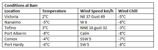
February is getting off to a cold and clear start. In the Capital Region temperatures this morning felt colder than they were, thanks to the wind. In other island cities winds were calm, but there was a definite chill.
The bright and brisk weather follows a month of cooler and drier than average conditions.
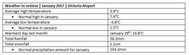
Looking back at January, the first month of 2017 had about one third of the normal amount of precipitation in Victoria.
Temperatures in the city were slightly cooler than average despite having three days with temperatures above 10°C.
Here’s a look at some of the statistics, based on data collected at Victoria Airport.
Later this week, when high pressure shifts and the next Pacific low pressure system makes its way towards Vancouver Island, another round of snow will blanket many parts of the island.
Friday is the day! The transition to rain may take place in some areas, but not others. Factors will include elevation, proximity to water and temperature.
Expect wintry weather to continue through the weekend.


