Rain and freezing rain warnings have been issued in New Brunswick as wet and windy weather moves into the Maritimes.
Freezing rain
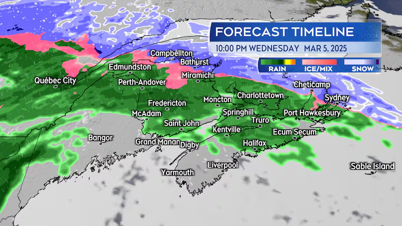
A snowfall of up to near five centimetres expected in northern New Brunswick Wednesday afternoon into evening. The snow will transition to a period of freezing rain Wednesday evening into the overnight hours. The period of greatest risk of freezing rain in northern New Brunswick is from about 9 p.m. Wednesday to 4 a.m. Thursday.
Lighter rain, drizzle, and fog are expected for the remainder of the Maritimes Wednesday night.
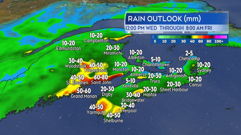
Rain, heavy at times, will develop in southern and central areas of New Brunswick Thursday morning into the afternoon. Further rainfall is expected Thursday night into Friday morning. Total rain amounts Wednesday through Friday morning could reach 40-to-90 mm for Fredericton and central New Brunswick, Saint John and southwestern New Brunswick, and in pockets just inland of the Bay of Fundy coastline all the way east to near Riverside-Albert.
Heavy rain, frozen ground, and additional snow/ice melt will increase the risk of flooding issues in those parts of the Maritimes. If you are able, you may wish to clear drainage systems on or near property to help with water runoff.
There is a moderate risk of downpours within the rain for southwestern Nova Scotia Thursday afternoon and evening. Communities in the southwest of Nova Scotia that see repeated downpours could finish with rain totals of 20-to-50 mm. Much of the remainder of the Maritimes, including Prince Edward Island, can expect rain totals of 10-to-30 mm Wednesday through Friday morning.
High and gusty wind
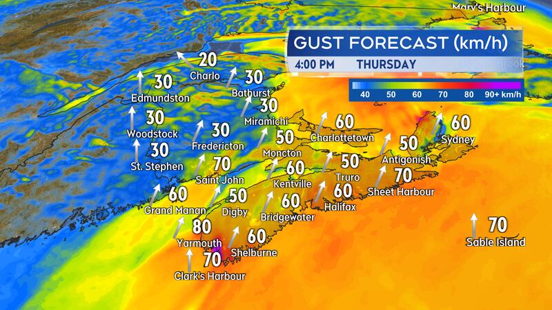
A southerly wind will increase across the Maritimes Thursday morning into Thursday afternoon.
There will be sustained wind speeds of 30-to-40 km/h with widespread peak gusts of 40-to-70 km/h. Gusts on exposed areas of the Bay of Fundy coastline of New Brunswick and Atlantic coastline of Nova Scotia reaching 70 to 90 km/h.
A Les Suetes wind is expected to develop in northern Inverness County, Cape Breton Thursday night into early Friday morning. That is a localized stronger wind created by the topography of the Cape Breton Highlands. The area at most risk stretches from near Cap Le Moine north to Meat Cove. Peak gusts Thursday night into early Friday may reach 110-to-130 km/h before diminishing.
The wind becoming west and northwest in direction on Friday. It will be sustained 15-to-30 km/h with gusts of 30-to-60 km/h.


