A low-pressure system will move out of the Great Lakes and into the Maritimes Thursday afternoon into Friday morning, bringing a mix of snow, rain, and gusty winds with it.
Weather alerts
Rainfall warnings are now in effect for the Atlantic coastal counties of mainland Nova Scotia from Yarmouth to Guysborough. The warnings call for 25 to 40 mm of rain Thursday afternoon until Friday morning. In the warmer seasons, that amount of rain wouldn’t typically be an issue.
In the winter however, snow and ice melt will add to the runoff, the ground is frozen, and drainage systems may be blocked by snow and ice. This increases the risk of localized flooding and ponding water.
Similar rain totals are expected in Cape Breton Thursday night through Friday afternoon. Due to the later arrival of the rain, Cape Breton remains under a special weather statement. Cape Breton picked up 12-to-25 mm of rain on Wednesday.
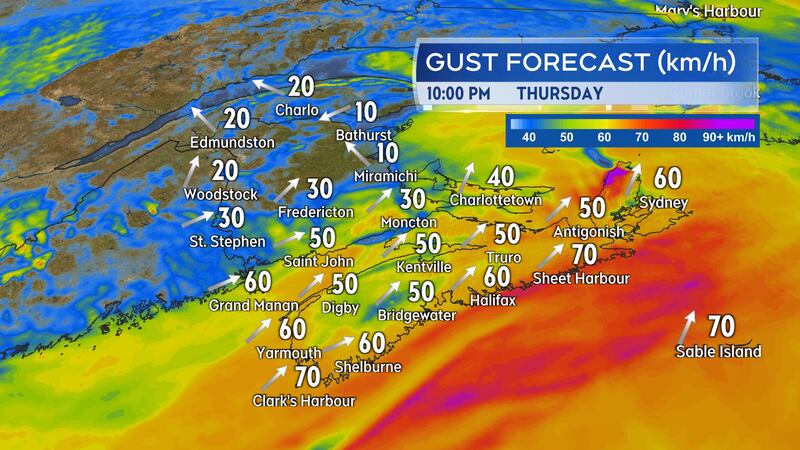
Southerly gusts peaking 60 to 80 km/h are expected on the Atlantic coastline of Nova Scotia Thursday evening and night. Due to the topography of the Cape Breton Highlands, northern Inverness County could peak with gusts near 110 km/h Thursday night. A wind warning has been issued for that area.
Snow and rain amounts
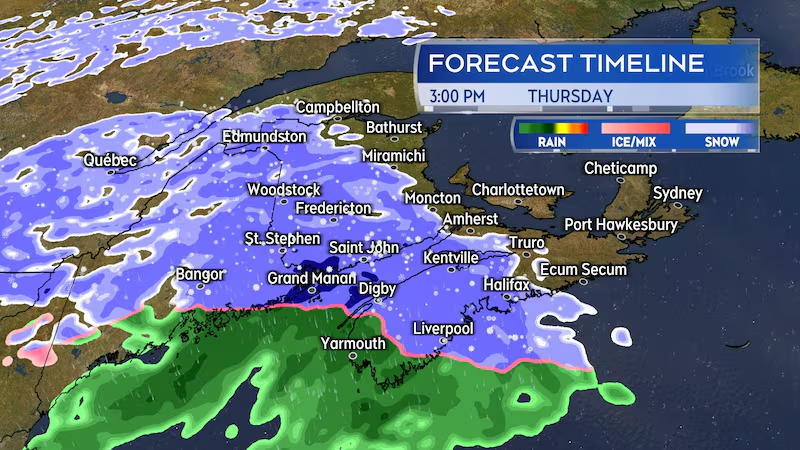
Snow arrives in southwestern Nova Scotia and western New Brunswick early Thursday afternoon. Snow is expected to develop across New Brunswick, Nova Scotia, and Prince Edward Island by late Thursday afternoon and early evening.
The snow in Nova Scotia will turn to rain within two-to-four hours. The snow is also expected to mix with rain in southern New Brunswick and Prince Edward Island. Rain may continue for parts of Prince Edward Island and eastern Nova Scotia through Friday morning.
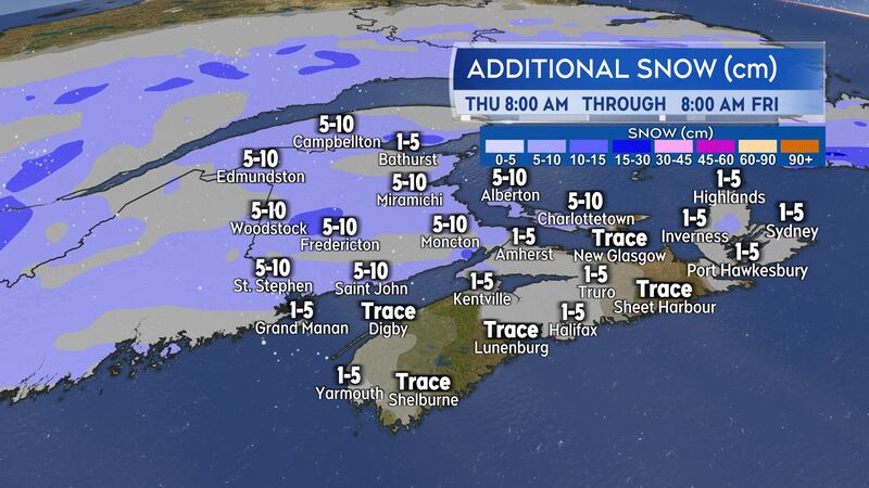
New Brunswick and Prince Edward Island may see five-to-10 centimetres of snow from the system. Due to the rain mixing in for southern New Brunswick and Prince Edward Island, there will be melting and compaction of that snow once it is on the ground.
Snow will generally total five cm or less for Nova Scotia followed by 15 to 40 mm of rain. As stated above, the higher rainfall totals are expected up and down the Atlantic coastline of the province.
March in like a lion?
Colder air moves back in behind the low-pressure system Friday night, with temperatures falling below freezing across the region by Saturday morning. Be careful of any standing slushy or wet surfaces turning icy.
A second low off the Great Lakes is projected to arrive Saturday afternoon into Sunday morning. Weather conditions will be similar to the Thursday system, in that it will likely be a mix of snow, rain, and gusty wind for the Maritimes. There is a chance that snow amounts with this second system could be higher in New Brunswick. There are early indications that some areas in that province could approach 10-to-15 cm.
Colder air returns behind the weekend low-pressure system and temperatures will fall back well below freezing Sunday into Monday. The first week of March off to a cold start in the region.