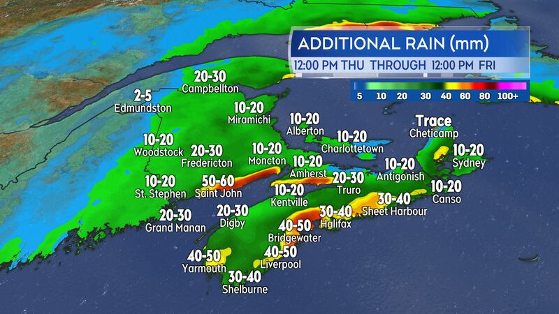
A slow-moving band of rain will continue to move across the Maritimes Thursday night into Friday. Rain totals are expected to be high for some areas with weather warnings continuing.
Rain and downpours
Thursday evening will see the most persistent rain fall over southern New Brunswick, western mainland Nova Scotia, and Prince Edward Island. The highest risk of downpours will be near the Bay of Fundy coastline in New Brunswick and western Nova Scotia. Overnight and Friday morning the greatest risk of downpours will be in eastern Nova Scotia, including Cape Breton.
Rain rates of five-to-10 mm an hour have been observed. That is a high enough rain rate to reduce visibility on roads with water runoff creating hydroplaning conditions. Patchy fog and drizzle during lulls in the rain will also reduce visibility.
Rain totals in central and southern areas of New Brunswick are likely to range 30-to-60 mm. Locally higher totals of 60 to near 90 mm on and just inland of the Bay of Fundy coastline. Rainfall warnings are in effect for much of central and southwestern New Brunswick.
Widespread rain totals of 20-to-50 mm are expected in Nova Scotia. The Tri-County region, Atlantic coastal counties, Minas Basin area of Cumberland/Colchester counties, and the Baddeck-Middle River area of Cape Breton are some of the locations with a higher risk of downpours. Rain warnings will continue for mainland Nova Scotia.
Prince Edward Island likely to receive 10-to-30 mm of rain. No Rainfall Warning in effect for that province.
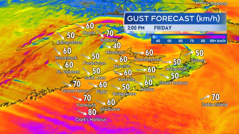
Gusty winds
A southerly wind has been increasing in strength Thursday morning into Thursday afternoon.
It is forecast to peak with gusts of 40-to-60 km/h for southern New Brunswick, Nova Scotia, and Prince Edward Island. Gusts as high as 60-to-80 km/h are possible on exposed areas of the Bay of Fundy coastline New Brunswick and Atlantic coastline of Nova Scotia. There will be peak gusts of 90 km/h or higher in northern Inverness County, Cape Breton Thursday evening into early Friday morning. A Wind Warning is in effect for that area of Cape Breton.
Wind will become northwesterly on Friday and remain gusty. Peak gusts of 40-to-60 km/h for the region but as high as 60-to-80 km/h for coastal areas of the Acadian Peninsula in New Brunswick, southwestern coastline of Nova Scotia, Inverness County in Cape Breton, and the northern coastline of Prince Edward Island.
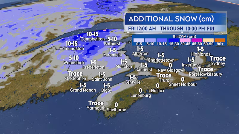
Switch to snow
Lingering rain and showers will turn to snow and flurries through the day Friday as temperatures fall.
For most of the Maritimes any snow is expected to be brief and light enough that either no accumulation or accumulations of one-to-five centimetres are expected. The exception may be western and northern areas of New Brunswick.
The west and north of New Brunswick could see the last part of the steadier rain flip over to snow early Friday morning. That snow would then continue into the afternoon before easing to flurries for the evening.
The area of the province starting near Woodstock moving north to Edmundston and then east to Bathurst could see a snowfall of five-to-15 cm on Friday.