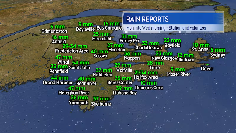
It was a soggy start to the week for the region with a number of areas receiving rain in excess of 20 and 30 mm. The warmer temperatures and wet weather are increasing ice breakup and movement on some of the river systems.
Rain totals
The slow-moving weather front that crossed the region Monday through Tuesday night generally brought the most rain to southern New Brunswick, western Nova Scotia, and western Prince Edward Island.
Saint John had one of the higher rain total reports with 54 mm, while Fredericton picked up 29 to 34 mm of rain. The Halifax area received a good soaking with 21 to 34 mm reported, the higher range was mostly from the Hammonds Plains area. Charlottetown picked up 33 mm of rain and freezing rain.
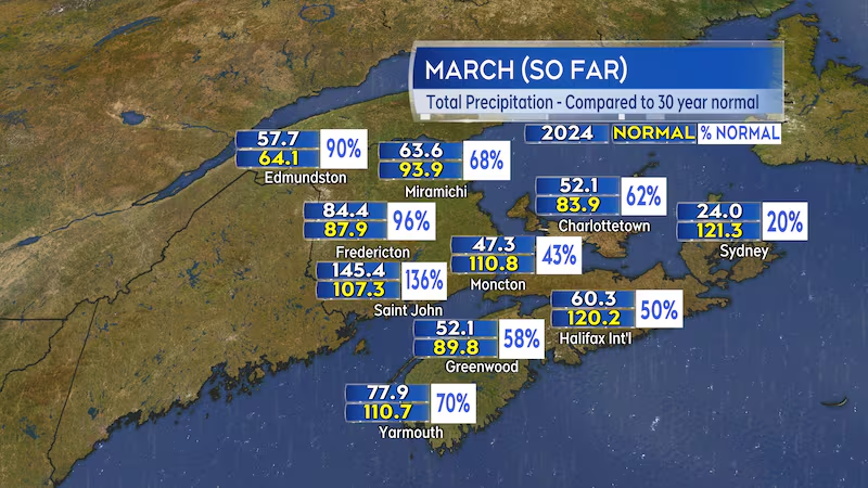
Western areas of New Brunswick are near or above the average amount of precipitation for the month. Parts of southwestern Nova Scotia and P.E.I. are starting to get close to the monthly average. The driest conditions, or at least lightest precipitation, so far this month have been in eastern areas of Nova Scotia. Sydney is sitting at only about 20 per cent of the average total precipitation for the month of March.
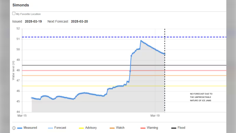
River watch update
Water levels at the monitored site near Simonds, N.B., rose above flood level on Tuesday. The rise was sudden and topped out just shy of the standing record high water mark. That type of sudden rise is often a sign that an ice jam has formed on the river. That ice jam was confirmed to me by viewer reports and pictures. I have yet to receive any reports that the high water has flooded roads or damaged any infrastructure.

The water is trending downward at that site on Wednesday though it remained above flood level as of 7 a.m. Hopefully that is a sign that the jam is beginning to break. The nearby sites of Woodstock and Hartland remain at the “watch” stage with respect to their reported water levels.
Cooler nights and milder days without any heavy rain events are typically best for an easing through the spring freshet. That allows the snowpack and river ice to release and flow through in a more controlled manner.
Weather outlook
Cool to chilly temperatures are expected Wednesday night into Thursday morning. Wind becomes southerly for Thursday, bringing some milder air into the Maritimes. As that mild air cools over ocean waters, that maintain a chilly one to four degrees near the Atlantic coastline of Nova Scotia and in the Bay of Fundy, it will condense into some low marine cloud, fog, and patchy drizzle. That type of weather can be expected for Atlantic coastal areas and communities on and near the Bay of Fundy in New Brunswick Thursday.
Parts of the Maritimes sheltered out of the southerly wind coming in directly off chilly ocean waters can expect high temperatures to rise towards the low-teens Thursday.
The next more significant weather system is expected to be a low-pressure system that develops in the northeastern U.S. Friday, moving into the Maritimes Friday night and Saturday. The low looks like it could pack another 10 to 30 mm of rainfall for a large part of the region. There is a chance that parts of northern and western New Brunswick could see accumulating snow on the colder, backside of the system on Saturday.


