A deep plunge into the southern U.S. of arctic-sourced air combined with a low-pressure over the Gulf of Mexico produced a historical snowfall for that region. It was part of the same Arctic air that brought a bitter cold into the Maritimes this week.
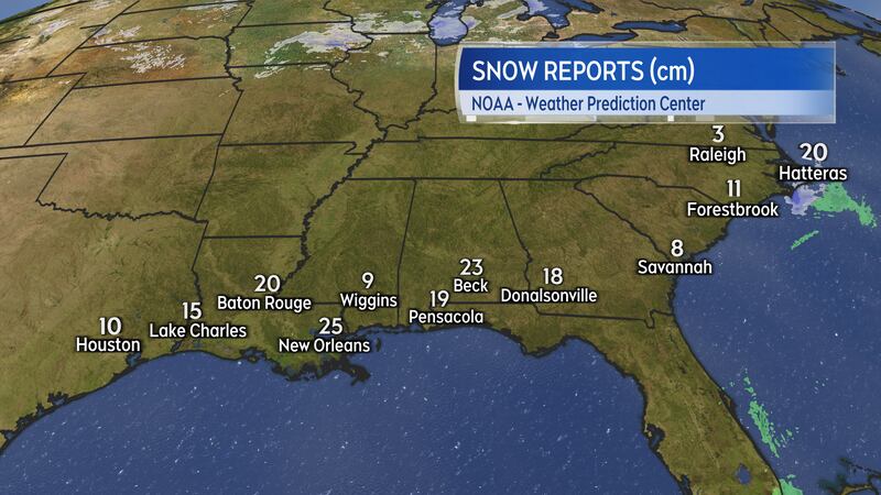
U.S. snow reports
Parts of Louisiana, Mississippi, Alabama, and Florida received 10 to 25 cm of snowfall over the past few days. Even Savannah, GA, picked up 8 cm of snow from the U.S. storm while Cape Hatteras, NC, reported near 20 cm.
New Orleans, LA, was one of the cities that picked up the most snow with near 25 cm reported. For reference, Halifax International Airport has only reported 10 cm of snow so far through the month of January – as much as Houston, TX, has had this month.
Other parts of the Maritimes, of course, have had substantially more snow. For example, Charlottetown has had 58 cm of snow so far this month and Fredericton near 59 cm.
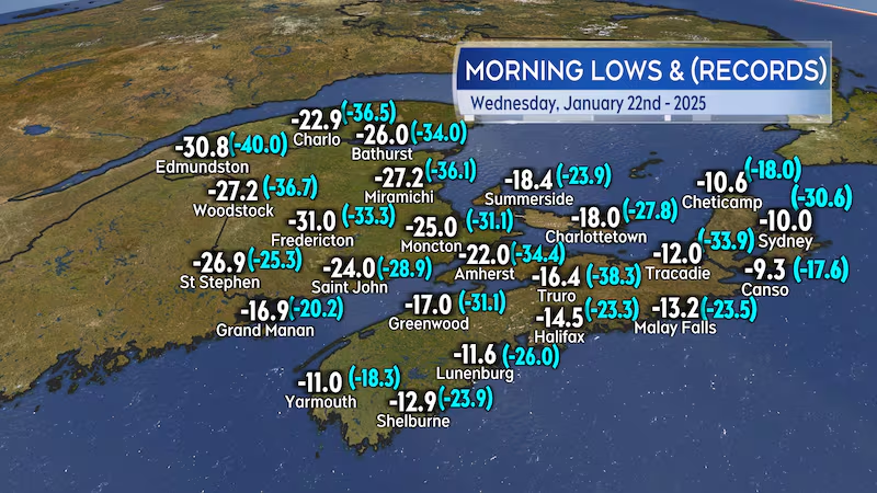
Maritime cold
Another frigid start to the day for the Maritimes on Wednesday. Morning low temperatures were well down into the negative-teens and negative-20s for most of the region. Fredericton started the day with a temperature near -31.
Despite the very cold temperatures, not much in the way of records were set. One record-low was set at St. Stephen, N.B., at -26.9 with records at that site going back to 1951.
Most standing low-temperature records for January 22 in the Maritimes are well down into the negative 20’s and 30’s. The standing low-temperature record for Edmundston, N.B., for a January 22 is -40. Many of the record-lows were set in either 1984 or 1934.
Outlook into the weekend
The cold air moderates slightly through the end of the week and into the weekend.
No big thaw or warm up, just a gradual return to seasonably cold conditions, and no sign of a significant winter storm over that period of time.
Early next week, a low-pressure system is projected to move through northern Quebec. That would sweep a cold front across the Maritimes on Tuesday. Another snap of colder air would follow in behind that front.
While still several days out from the forecast, that next round of colder air next week doesn’t look like it will match the temperature plunge of this week.


