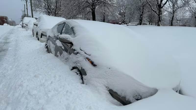
New weather alerts have been issued in the Maritimes as a snowy and icy mix of weather is set to develop across the region on Thursday.
Here is a breakdown of what to expect for each province.
New Brunswick
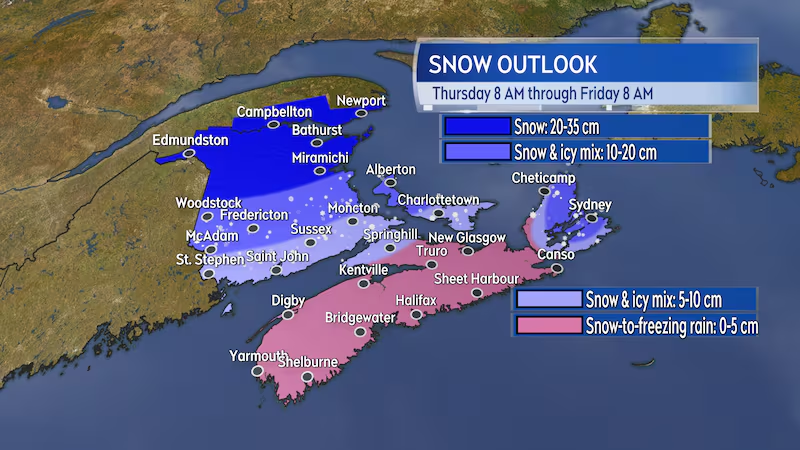
Snowfall warnings are now in effect for much of northern and central New Brunswick. The warnings call for snow and ice pellets totalling 15 to 25 cm, though higher snow totals nearing 35 cm are possible for northern areas of the province.
A special weather statement remains in place for southern areas of New Brunswick, where snow is expected to turn to a mixture of ice pellets and freezing rain. While that will work to keep overall snow totals less than 15 cm, it will still create slippery roads, and any snow that does accumulate will be heavy to clear.
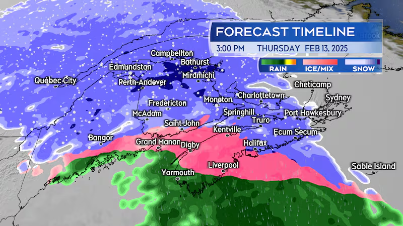
The first of the snow is expected in western New Brunswick by 8 a.m. Thursday, with the snow reaching eastern areas of the province by noon.
The snow will turn to a mix of ice pellets and freezing rain in southern New Brunswick Thursday afternoon, so road conditions will likely deteriorate quickly.
The wintry mix will clear by midnight Thursday into Friday.
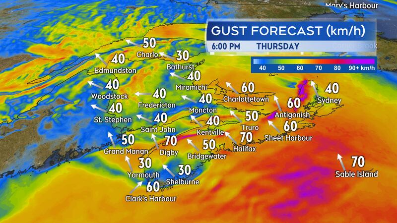
Southeasterly winds gusting from 30 to 50 km/h are expected to accompany the snow, ice pellets, and freezing rain. The wind will turn northwest Thursday night and will be gusty and cold on Friday.
Nova Scotia
Mainland Nova Scotia remained under a special weather statement as of noon Wednesday. Initial snow amounts of 5 cm or less are expected for most communities followed by a turn through ice pellets to freezing rain.
Cape Breton is under a winter storm watch. Higher snow and ice pellet totals of 10 or more centimetres are expected beginning near Sydney and extending into Victoria and northern Inverness counties. Southeast winds will peak with gusts near 80 km/h Thursday evening. Stronger gusts of 130 km/h are expected in northern Inverness County due to the topography of the Cape Breton Highlands. The stronger winds will create more extensive periods of blowing snow.
The first of the snow is expected in southwestern Nova Scotia by 10 a.m. Thursday, with the snow turning to ice pellets and freezing rain across the mainland by the early afternoon. Road conditions will become slick and possibly icy through the afternoon, with a risk of freezing rain from about noon to 8 p.m.
Cape Breton will see the snow develop from 3 p.m. to 5 p.m. The snow will mix with ice pellets and freezing rain through the evening. More snow is expected to accumulate in Cape Breton compared to the mainland.
The wintry mix will clear mainland Nova Scotia Thursday evening and clear Cape Breton later Thursday night.
Southeast gusts of 40 to 60 km/h are expected to accompany the icy mix of weather. Peak gusts of 60 to 80 km/h are possible on exposed areas of the coastline and higher terrain. Gusts could approach 130 km/h in northern Inverness County Thursday evening and night. The wind will turn northwest by Friday morning and will be gusty and cold for Friday.
P.E.I. and the Magdalen Islands
A special weather statement remained in effect on P.E.I. as of noon Wednesday. The statement is calling for snow totals of 15 to 25 cm for western areas of the province and 10 cm of snow and ice pellets for central and eastern P.E.I.
The Magdalen Islands are under a winter storm watch. Snow totals of near 20 cm are expected Thursday afternoon through early Friday morning, with peak wind gusts reaching near 90 km/h.
P.E.I. can expect the first of the snow to show up between noon and 2 p.m. on Thursday, with the snow turning to a mix of ice pellets and freezing rain Thursday evening. The icy mix is expected to ease to a chance of flurries by midnight. Expect road conditions in the province to deteriorate quickly mid-afternoon into early evening.
Southeast winds with gusts peaking near 60 km/h will accompany the wintry mix. Like the rest of the Maritimes, the wind becoming northwest by Friday morning. Gusts peaking between 60 and 80 km/h are expected on Friday.
I’ll have updates at CTVNewsAtlantic.ca and on CTV at 5 p.m., 6 p.m. and 11:30 p.m.