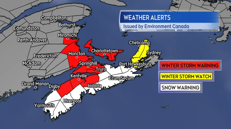
Snowfall warnings are now in effect for mainland Nova Scotia and southeastern New Brunswick. A Special Weather Statement is in place for Cape Breton and Prince Edward Island was put under a Winter Storm Warning Friday morning.
Weather Warnings
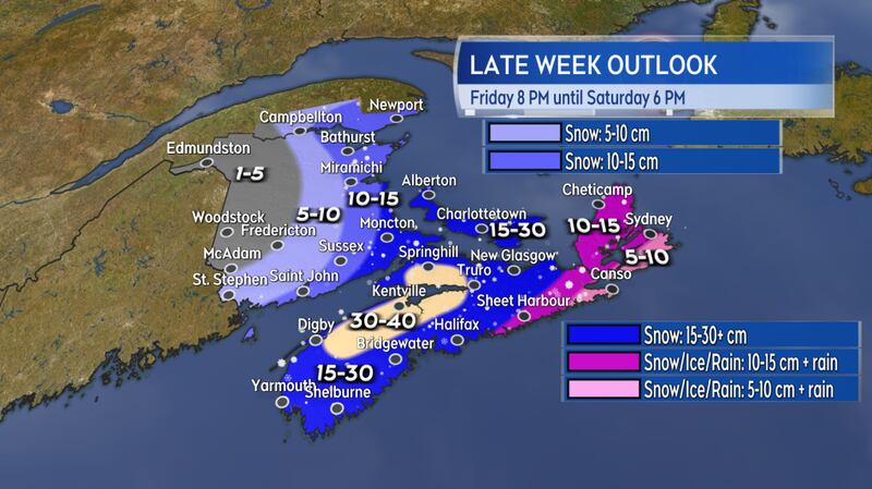
The warnings in place for the region call for snow totals reaching 15-to-40 cm Friday night through Saturday evening.
In Nova Scotia, the Valley, along with Colchester and Cumberland counties are expecting 30-to-40 cm and are under a winter storm warning. Snow in those areas is expected to start Friday evening and continue through Saturday evening.
Eastern mainland Nova Scotia, as well as Yarmouth, Digby and Shelburne counties are under a snowfall warning where 20-to-30 cm is expected. The snow may mix with ice pellets and rain Saturday morning.
Eastern Cape Breton remains under a special weather statement where 10-to-15 cm of snow is expected, before a turn to ice pellets and rain Saturday morning.
Inverness and Victoria counties are under a winter storm watch, with snow totals forecast to reach anywhere between 20 to 30 cm. That includes snow squalls that are expected to develop Saturday night.
Freezing rain is expected to move into the Highlands Saturday morning, bringing a risk of slippery roadways.
A winter storm warning for Prince Edward Island calls for snow 25 to 35 cm, and peak northerly wind gusts that could reach 80 km/h on Saturday. The stronger wind combined with the snow is likely to create extended periods of whiteout conditions. The warning recommends postponing non-essential travel in the worst of the conditions.
Eastern New Brunswick is under a winter storm warning where 15 to 25 cm is forecast to fall. Snow is expected to start late Friday night and continue through Saturday evening.
Gusty winds in that province will also lead to reduced visibilities in blowing snow on Saturday, especially along exposed areas of the coast.
Snowfall outlook
A broad swath of 15-to-30 cm of snow looks likely to come across mainland Nova Scotia, the southeastern corner of New Brunswick, and Prince Edward Island. Gusty winds could allow for snow drifts to pile higher. The Annapolis Valley and Cumberland/Colchester Counties may finish with some totals of 30-to-40 cm, especially for locations in higher terrain.
A quicker change to ice pellets will start just to the east of Halifax and continue across Guysborough County into Cape Breton. Those areas should be cautious as the initial snow and ice pellets could still add up to five-to-15 cm, creating slippery, snow covered roads.
Moncton and the southeastern corner of New Brunswick could catch the heavier snow and should be ready for 15-to-30 cm. The snow is expected to taper lighter into northern and western areas of New Brunswick.
Much of the heaviest snow looks like it will come in Friday night through Saturday morning. Periods of lighter snow are expected to continue through Saturday afternoon. There will be flurries Saturday evening and night along with a risk of snow squalls for eastern areas of Nova Scotia and Prince Edward Island. The risk of snow squalls develops as a cold northwest wind begins to blow over the Gulf of St. Lawrence and the Northumberland Strait.
Wind
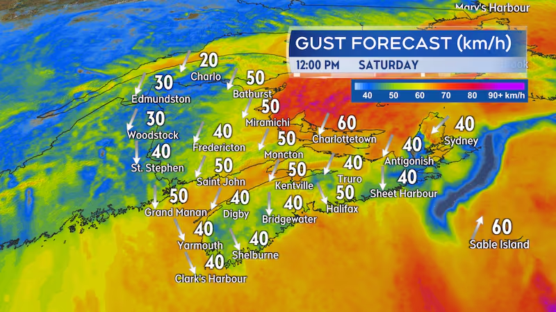
A gusty north and northeast wind will develop by Saturday morning. There will be peak gusts of 30-to-60 km/h except for highs of 60-to-70 km/h on exposed areas of the Atlantic coastline of Nova Scotia. While below warning criteria, it is enough to blow the falling snow around, reducing visibility.
By Saturday afternoon, the strongest northerly winds are expected in Prince Edward Island, peaking at 60-to-80 km/h. At that time much of the remainder of the Maritimes will be turning over to a northwest wind with gusts of 40-to-60 km/h. Wind gusts are expected to diminish into a range of 20-to-40 km/h by Sunday morning.
Weather impacts
The heavy snow will create slippery roads and difficult driving conditions. Those areas under a snowfall and winter storm warning should expect conditions to deteriorate quickly once the snow begins. In many cases it will only take about two hours for the snow to go from light to steady, or even heavy at times. For much of the Maritimes the worst of the weather will occur late tonight through Saturday morning. The exception may be Prince Edward Island where the stronger north wind Saturday afternoon could bring persistent periods of heavy, blowing snow.
Check on any municipal winter parking bans. Have easy access to snow shovels and snowblowers. If using a snowblower check to make sure it is in working order and that you have fuel.
Check for event cancellations and travel service disruptions. Some ferries in the region have already announced cancellations and possible further sailing delays