A low-pressure system bringing a mix of snow and rain Saturday night into Sunday is followed by a second system on Monday. After that, Arctic sourced air as a result of a breakdown in the polar vortex moves into the Maritimes.
Weekend rain and snow
Saturday will see a cold start to the day. Cloud cover increasing through the day with a low chance of spotty flurries. Wind becomes southerly and steadily increases to become gusty by evening. Temperatures rise through the day but also Saturday night into Sunday morning.
A low-pressure system moving through New England brings a mix of snow and rain starting Saturday night. Snow will develop across western New Brunswick and rain in southwestern Nova Scotia near 10 p.m. The snow and rain fill in across the Maritimes into Sunday morning. Western parts of the Maritimes clearing the weather Sunday morning. Eastern areas clearing Sunday afternoon and evening.
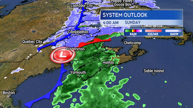
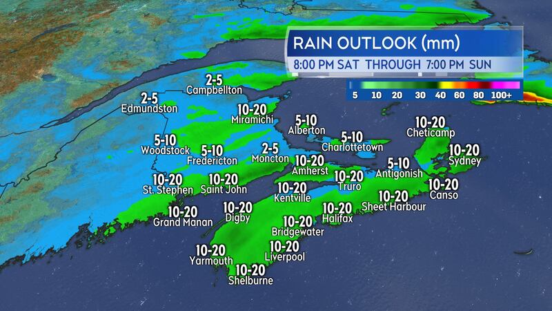
The Maritimes will receive mostly rain, with totals 10-to-25 mm. Water runoff may be increased by snow melt and the frozen ground, as well as any blocked drainage. Northern areas of New Brunswick could pick up two-to-six centimetres of wet snow with near 10 cm in higher terrain.
The southerly wind will be gusty Saturday night into Sunday morning, peaking 40 to 70 km/h with the highest gusts on exposed areas of the coast and higher terrain. Northern Inverness County could peak with gusts in excess of 100 km/h Sunday morning as a result of the topography of the Highlands. Wind will become northerly and diminish across the region by Sunday evening.
Round two on Monday
A second low-pressure system originating out of the southeastern United States will return a mix of snow and rain to the Maritimes on Monday.
Indications at this time are for Nova Scotia and Prince Edward Island to see the snow turn to rain. A special weather statement has been issued in New Brunswick by Environment Canada cautioning on possible heavy snow Sunday night and Monday. It is still possible for a significant change in where the snow-rain line with the Monday system will occur, so please monitor your forecast for updates on Monday through the weekend.
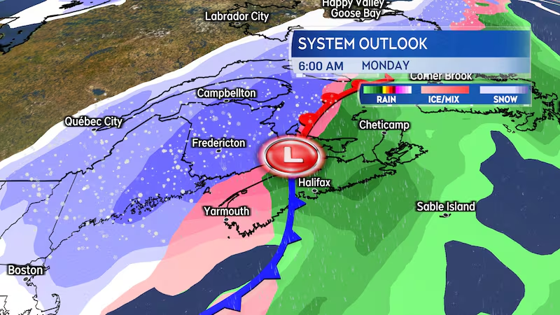
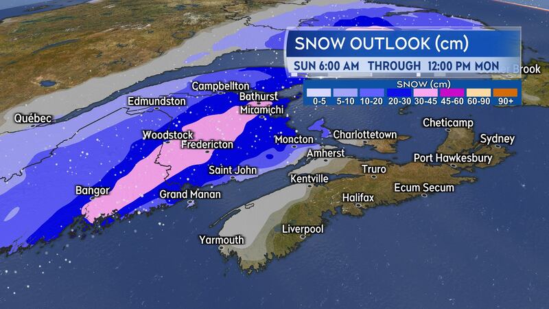
The Monday system looks to be the stronger, more potent of the two. That brings an increased risk of heavier precipitation, and New Brunswick could see a 15-to-30 cm snow event. That was being indicated by computer forecast models run out of the U.S. and Canada on Friday. Rain for Nova Scotia and Prince Edward Island could total 10 to 30 mm.
Again, you will want to check in on the Monday forecast for your area a few times through the weekend. A movement east of the system would bring the potential for areas of heavier snow into Nova Scotia and Prince Edward Island.
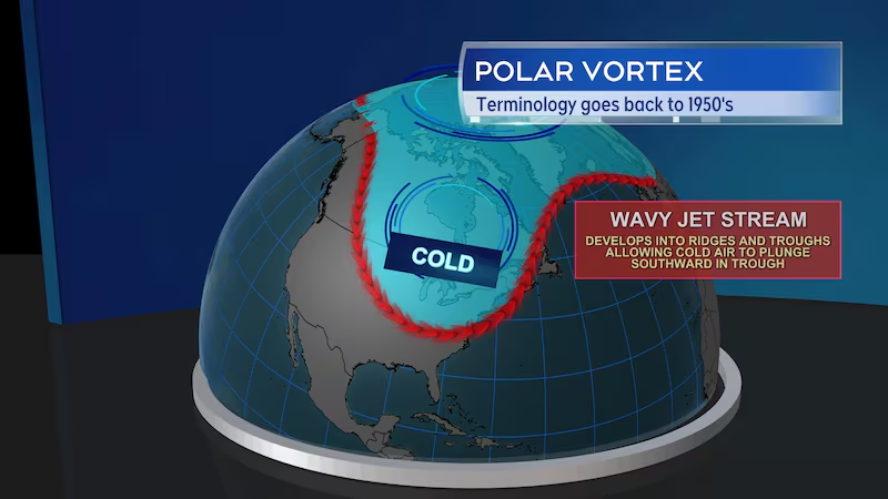
Polar vortex flex
You’ve probably heard about a snap of bitterly, cold winter air that will move across a large part of the country this weekend into next week. It is attributed to a movement in the polar vortex.
What is the polar vortex? In a nutshell, it is semi-permanent circulation of very cold air aloft of the polar region. During the winter season, when the jet stream across North America takes a wavy pattern that climbs high into the polar region before dipping far to the south, that vortex of frigid air can distort and shift southward with it. These outbreaks of Arctic sourced air often bring the coldest stretches of winter temperatures. This outbreak of the polar vortex will bring the coldest temperatures of the season so far to much of the Prairies, Ontario, Quebec, and next week, Atlantic Canada.
Colder air starts to filter into the Maritimes by Monday. The region really feeling the bite of polar air by Tuesday and Wednesday. Monitor your areas temperature and wind-chill forecast and adjust wear and activities as needed through the cold snap.


