There was a fine display of lunar halos before some snow for parts of the Maritimes on Sunday. Following the Sunday snow, bitterly cold air has moved back in place for the region.
Lunar halo
A number of great pictures were sent in of a lunar halo observed Saturday night in the Maritime sky.
A lunar halo is the same effect as a solar halo. Tiny ice crystals that comprise of thin, high cloud in the atmosphere reflect the lunar light and produce the halo effect.
The presence of halos has a place in weather folklore, “halo around the moon expect rain soon.” Those thin, high clouds mentioned above often run out ahead of a low-pressure system packing lower cloud and precipitation. In this case, the system brought snow and flurries to the region on Sunday.
You can have situations where the high cloud is separate from an approaching rain or snow-bearing weather system. In that case, halos can be observed, but won’t be followed up directly by rain or snow.

Sunday snow reports
A low-pressure system exited the northeastern U.S. on Sunday, moving south and east of Nova Scotia.
The track of the system kept colder air in place, and hence it was a straight up snow event for the region. The most snow was closest to the path of the system, hence higher reports from southwestern and Atlantic coastal Nova Scotia.
A fluffy, powdery snowfall, it totalled near 15 cm for parts of Digby, Yarmouth, Shelburne Counties and then 10 to 15 cm moving up the Atlantic coastline as far as Guysborough County. Other parts of the Maritimes reported snow amounts ranging from trace to several centimetres in lighter snow and flurries.
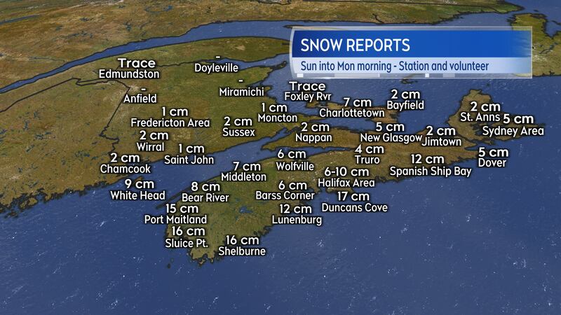
The same system dumped 40 centimetres of snow in St. John’s, N.L., grounding flights, shutting down schools and stopping public transit.
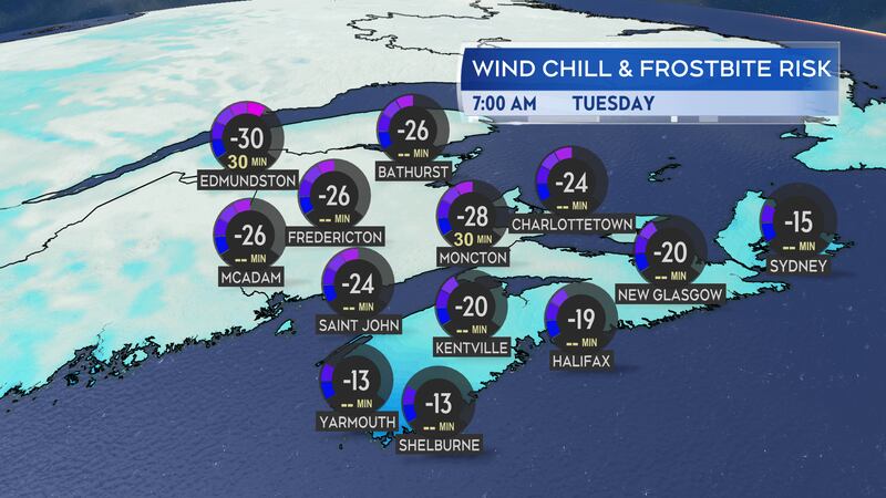
Bitter cold continues, active weather to end the week
Polar-sourced air lingers in the Maritimes and it will feel frigid for a good portion of this week.
Low temperatures Monday night into Tuesday morning are expected to dip into the minus-teens and minus-20s for most of the Maritimes. The wind chill will make it feel into the minus-20s for most of the Maritimes to get Tuesday started.
The next round of more active weather is lined up for Thursday of this week. A Texas Low is expected to move into the Maritimes on that day. The system looks likely to pack a heavier snowfall of 15 or more centimetres for parts of New Brunswick and Prince Edward Island. Nova Scotia will receive a wintry mix of snow turning through ice pellets to freezing rain and rain.
Updates through the week can be found on CTV News Atlantic news programming and here at ctvnewsatlantic.ca.


