A low-pressure system moving north out of the U.S. brought a snowy, icy mix of weather to the Maritimes on Thursday. A similar system is expected to bring a near repeat of conditions Sunday into Monday.
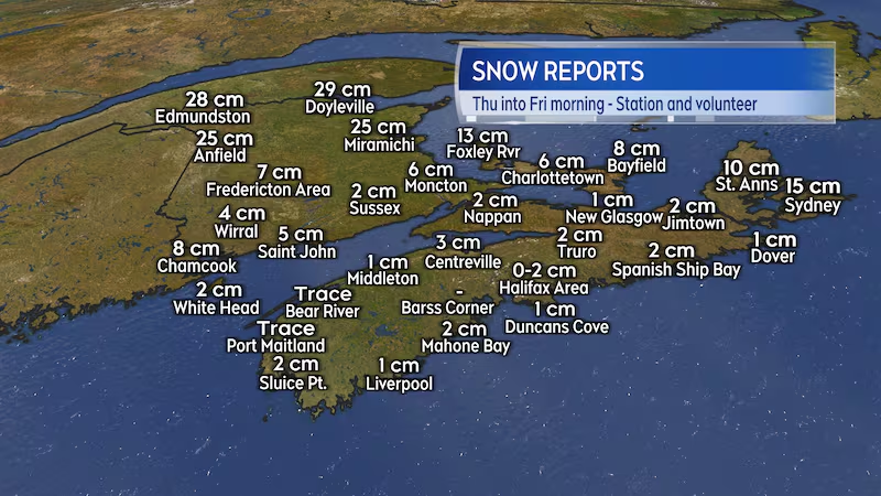
Storm reports
As expected, the heaviest snow on Thursday fell across areas of northern New Brunswick with reports of 20 to near 30 cm. Snow totalled lower for much of the remainder of the Maritimes with more ice pellets and freezing rain present.
The combination of ice pellets and freezing rain contributed to icy roads and other surfaces. Not helping matters was a rise above freezing in temperature for much of Nova Scotia Thursday evening before a fall back below freezing by Friday morning. The thaw and freeze contributed to further icy spots.
Fierce winds blew across parts of northern Inverness County, Cape Breton, Thursday night. These infamous Les Suetes winds are a result of the topography of the Highlands, which amplifies them when the wind is south and southeast in direction. A personal weather station located near Plateau reported a peak gust of 209 km/h, a station at Grand Etang reported a peak gust of 174 km/h, and a station at Cheticamp Island reported 159 km/h.
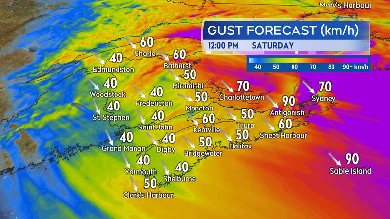
High wind continues Friday into Saturday
In the wake of the storm system, a high and gusty northwest wind continues to blow across the Maritimes on Friday.
A blowing snow advisory is in effect for the Bathurst area and Acadian Peninsula, which could continue to contend with blowing and drifting snow into Saturday
A wind warning continues for Kings County, Prince Edward Island. Northwest gusts peaking near 90 km/h are expected to continue until Saturday morning.
In Cape Breton, northern Inverness and Victoria Counties are under a winter storm warning. Snow squalls continue in the Highlands and could contribute another 30 cm of snow at the higher elevations into Saturday. Northwesterly gusts of 90 km/h continue to create periods of blowing snow. The rest of Cape Breton is under a wind warning. Occasional gusts nearing 90 km/h are expected to continue into Saturday.
The high winds have resulted in ferry sailing cancellations between Nova Scotia and Newfoundland both Friday and Saturday.
Round two on Sunday
A second winter storm will move out of the U.S. and into the Maritimes on Sunday. Impacts are expected to be similar to the round of weather on Thursday.
Weather conditions in western parts of the Maritimes will deteriorate Sunday afternoon into evening. Conditions will worsen in eastern parts of the region with inclement weather continuing Sunday night that could linger for some areas into Monday morning.
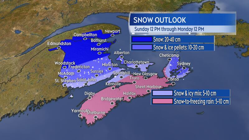
The heaviest snow from the second storm is lined up to once again fall across northern New Brunswick. Snow will total lower into southern parts of that province and P.E.I. where more ice pellets are expected. Nova Scotia is forecast to start as snow, then switch through to ice pellets over to a period of freezing rain and rain. Temperatures in that province will rise above zero Sunday night before falling back below freezing Monday morning. Any standing wet or slushy surfaces will be turning icy on Monday.
I highly recommend keeping tabs on the forecast for your area this weekend, including checking in on any weather alerts issued.