A stalled storm system near Newfoundland continues to bring snow into the Maritimes. Light for the most part, there are areas where the snow is expected to total higher over the next 48 hours as it becomes enhanced by either coming in off the ocean or occurring in higher terrain.
Snowy spots to watch
A Snowfall Warning remains in effect for northern Inverness County, N.S. Through Thursday morning snow amounts of 20-to-30 cm are possible in parts of the Cape Breton Highlands. Lower elevations could see spots of snow ranging five-to-15 cm.
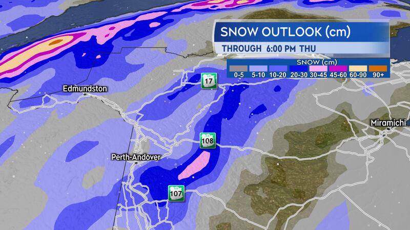
The mountainous terrain in New Brunswick from Carleton County north to Restigouche County could pick up 10-to-20 cm of snow through Thursday. Caution should be taken on any of the roadway routes that climb into higher terrain through this area. Roads could become snow covered and slippery.
The Annapolis Valley and Digby County of Nova Scotia could also pick up varied snow totals of five-to-20 cm over the next 48 hours. Guidance for the higher amounts starts near the Greenwood area in the Valley and extends towards Meteghan in Digby County. The higher snow totals are most likely in hilly terrain. It is possible that five-to-10 cm of snow falls Wednesday evening and night, with another five-to-10 cm possible on Thursday.

Breaking free of the pattern
A ridge in the jet stream centred over the North Atlantic has prevented the Newfoundland storm from clearing to the east. The block has been breaking down over the last 24 hours and will allow for the storm to finally move east Friday into Saturday. Flurries will become more spotty in coverage on Friday.
Another storm system strengthens off the U.S. eastern seaboard on Saturday. Current indications are for the storm to hold far enough south and east of the Maritimes to only have a marginal influence on our weather. A round of lighter snow and flurries may develop Saturday evening and night. The snow diminishes to scattered flurries on Sunday.
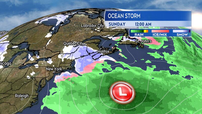
I recommend keeping tabs on the weekend forecast. Should the storm come in closer to the region than is currently expected, it would increase the amount of snow the Maritimes can expect. Unlike the stalled storm near Newfoundland, this second storm system is expected to exit out into the North Atlantic.