A Colorado low has developed into a late season winter storm. The storm will move across the U.S. Midwest and then towards the St. Lawrence River Valley. Rainy and windy conditions will develop for the Maritimes Thursday into Friday.
Large, sprawling storm
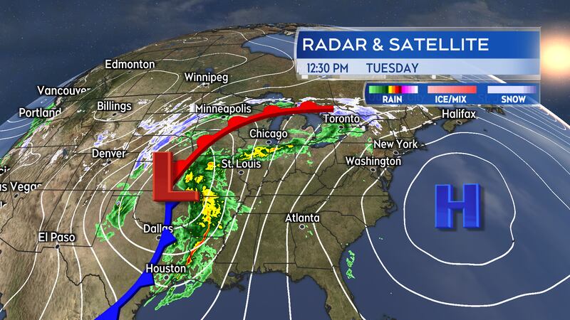
On Tuesday, the centre of the storm was over the state of Kansas. The central pressure of the storm system had fallen to near 990 millibars, making it a mature low-pressure system with further strengthening expected as it progresses into the U.S. Midwest. The storm is being energized by moving along the border of colder air centred over the Canadian Prairies and warmer air centred over the U.S. Gulf states.
It is a very large weather system. The weather fronts associated with it stretch from the border of Texas and Mexico all the way up through the U.S. Midwest and into Ontario. The storm is triggering weather advisories and warnings related to wind and winter weather conditions along that path. A winter storm warning is in effect for the Nickel Belt area of Ontario where a snowfall of 20 to 30 cm is expected for some areas. Special weather statements extend across southern Ontario and into Quebec. Those areas will receive a mix of snow, freezing rain, and rain Tuesday into Thursday.
The weather front from the storm will reach the Maritimes on Thursday. The centre of the storm will be nearing New Brunswick by early Friday morning.
Rain preceded by flurries and showers
A preliminary round of light snow turning to light rain is expected in the Maritimes Tuesday night into Wednesday afternoon. The light precipitation will be running out ahead of the northern edge of the approaching system.
Widespread flurries Tuesday evening and night may bring some localized snow totals of one-to-five centimetres. Remaining flurries will turn to rain showers Wednesday morning.
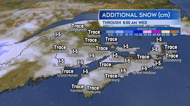
A mix of snow and rain develops in New Brunswick Wednesday afternoon into evening. Some initial snowfall amounts of up to 5 cm is possible in northern New Brunswick before the turn to rain by near midnight. There is a risk of some freezing rain during the transition.
Periods of rain, drizzle, and fog are then expected across the Maritimes Thursday into Friday. Rain totals of 20 to 50 mm are being indicated near the Bay of Fundy coastline in New Brunswick, much of Nova Scotia, and much of Prince Edward Island. The bulk of that rain would fall between 8 a.m. Thursday and 8 a.m. Friday.
With the ground still mostly frozen and the addition of snow/ice melt, a risk of localized flooding will accompany the rainfall.
Outlook for winds
A high and gusty southerly wind will develop Wednesday overnight into Thursday morning.
Peak gusts of 50 to 70 km/h, except 70 to 90 km/h for coastal areas and higher terrain, will be present Thursday morning. A Les Suetes wind situation is likely to develop in northern Inverness County, Cape Breton, late Thursday afternoon and extend through Thursday night. That is a very strong localized wind condition created by the topography of the Cape Breton Highlands. Similar weather systems in the past have produced Les Suetes winds gusting to 130 km/h or more.
The strongest winds are forecast to diminish in New Brunswick and western Nova Scotia Thursday evening. Winds will be diminishing for the remainder of the Maritimes Thursday night into Friday morning. A gusty westerly wind is expected to follow for Friday.


