
The modest swipe of snow for southwestern parts of the Maritimes on Thursday has exited to the east.
Some preliminary reports had 8 cm in Yarmouth, N.S., 11 cm in Sluice Point, N.S., and 15 cm in Clark’s Harbour, N.S., which are all in the southwest of the province.
A colder northerly wind continues to bring flurries into areas of Prince Edward Island and eastern Nova Scotia off the Gulf of St. Lawrence.
Another low-pressure system moving across the continental United States will return snow to larger parts of the Maritimes Thursday night into Friday morning.
That system will exit north of Cape Cod near 2 a.m. Friday, before passing east of Cape Sable Island in the southwest of Nova Scotia by noon.
Light snow and flurries will develop across the Maritimes late Thursday night into early Friday morning. The snow will become steadier for parts of southwestern New Brunswick and western Nova Scotia Friday morning into early afternoon.
By mid-to-late afternoon Friday, the snow will have eased to scattered flurries in the Maritimes.
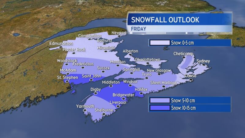
Northern New Brunswick, P.E.I., and parts of eastern Nova Scotia will see the lowest snowfall with amounts ranging from trace up to a few centimetres.
Parts of the north shore of mainland Nova Scotia, as well as Inverness and Victoria counties in Cape Breton, will see totals of 5 to 10 cm. There will be some contribution from snow off the Gulf of St. Lawrence. Much of southern New Brunswick and western Nova Scotia can expect 5 to 10 cm as well.
A band of 10 to 15 cm of snow is possible from Saint John, N.B., in the southwest of New Brunswick across the Annapolis Valley and into the south shore of Nova Scotia.
Ice pellets may mix in with the snow for the Tri-County area of southwestern Nova Scotia. Snowfall warning criteria for the Maritimes is 15 cm of snow or more in 12 hours or less. This event generally won’t reach that criteria and no warnings or statements are currently in effect.
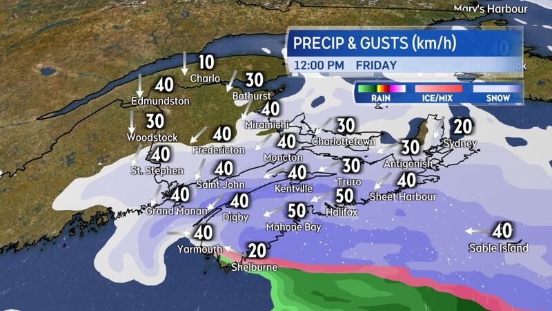
A gusty northeast wind will accompany the snow on Friday. Gusts will increase from 20 to 30 km/h in the morning to 40 to 60 km/h by early afternoon. The higher end of the range of wind gusts will be most likely near the Bay of Fundy coastline in New Brunswick and in the west of Nova Scotia.
With colder air in place, the snow is likely to be of the “fluffier” variety, which could result in some blowing/drifting snow as it combines with the wind. Wind will turn northerly Friday night with gusts gradually diminishing into ranges of 20 to 40 km/h by Saturday morning.
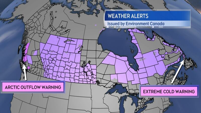
The northerly wind heading into the weekend will tap into the latest round of Arctic air that has broken down across the country. That colder air will be sourced out of northern Quebec and western Labrador where extreme cold warnings are in effect. Alerts related to bitterly cold temperatures run from the Pacific to the Atlantic across the country at the moment.
An arctic outflow warning is in place for the central coast of British Columbia, with extreme cold warnings stretching across the prairies, northern Ontario and Quebec, and into the northern peninsula of Newfoundland.
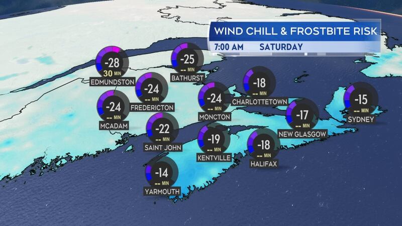
Extreme cold warning criteria for the Maritimes is two or more hours of a wind chill making it feel -35 C or colder.
It doesn’t look likely the region will be quite that cold over the weekend. There will be some wind chills, making it feel into the -20 C range for New Brunswick and P.E.I. both Saturday and Sunday morning. Nova Scotia will see wind chills making it feel well into the minus teens both mornings.
The colder air may linger for one of the longest stretches yet this winter in the Maritimes.
Temperatures are generally forecast to be near-to-below seasonal averages until at least late next week. For reference, average high temperatures for this time of the year are generally near to a few degrees below zero degrees with average low temperatures ranging from -8 C to -13 C. Long-range guidance has the colder air moderating by Thursday/Friday of next week.


