There will be fluctuating temperatures along with sunny periods through much of this week in the Maritimes. Cloudier conditions and rainy weather are looking likely for the end of the weekend.
The ups and downs of March
The Spring Equinox is at 6:01 a.m. on March 20 this year. Spring is a transition season and as such can often see occasional swings between colder and milder temperatures. The Maritimes has some of that ahead through the first part of this week.
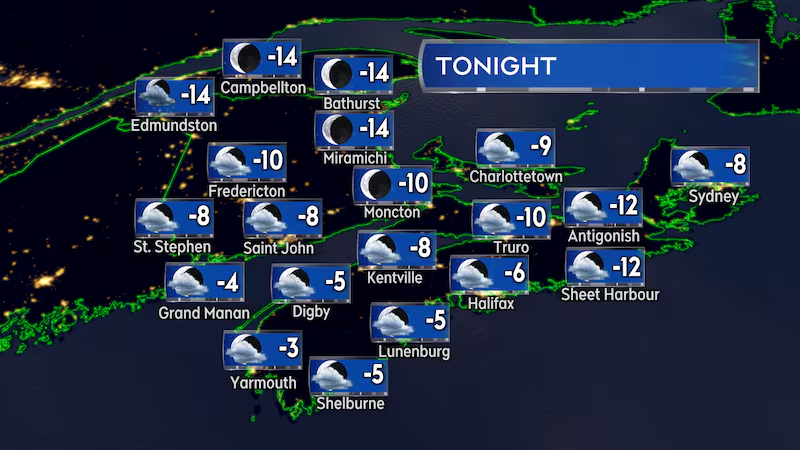
Monday night will be colder with overnight low temperatures near to a few degrees below early March averages. Lows in New Brunswick will be mostly -8 C to -15 C, Nova Scotia will be -6 C to -12 C, and Prince Edward Island will be -7 C to -10 C.
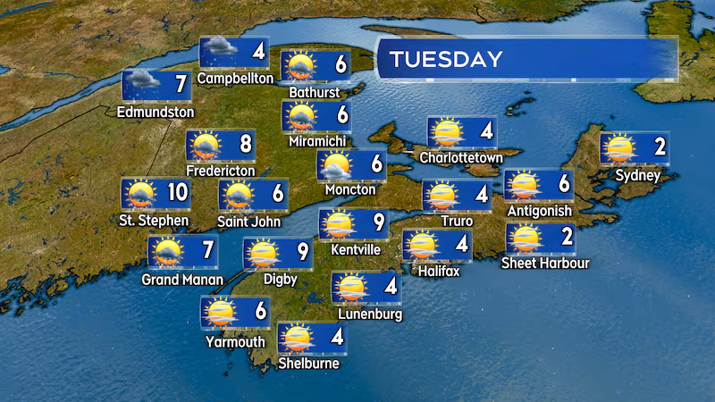
A southerly wind will develop for Tuesday. The wind will pick up to become a bit blustery by late afternoon with gusts of 30 to 50 km/h. The southerly direction of the wind will also allow afternoon highs to recover into a range of 4-to-10 C for the region, slightly cooler in Cape Breton with highs of 2 C to 5 C.
A weak cold front will pass Tuesday night into early Friday morning, bringing a few showers and flurries along with it. The front also returns a northwest wind to the Maritimes and sends temperatures back to colder early March conditions.
Daytime temperatures for New Brunswick are expected to be near to a few degrees below freezing on Wednesday. Nova Scotia and Prince Edward Island start Wednesday morning with milder temperatures of 2-to-8 C but will fall to and below freezing by the afternoon and evening. Temperatures Wednesday overnight into Thursday will be colder for all three Maritime provinces, ranging -12 C to -20 C for New Brunswick, -6 C to -12 C for Nova Scotia, and -7 C to -10 C for Prince Edward Island.
Temperatures are expected to moderate moving into and through the weekend.
Sunny periods and a lunar eclipse
On the plus side it looks like there will be some stretches of decently bright weather for the region this week.
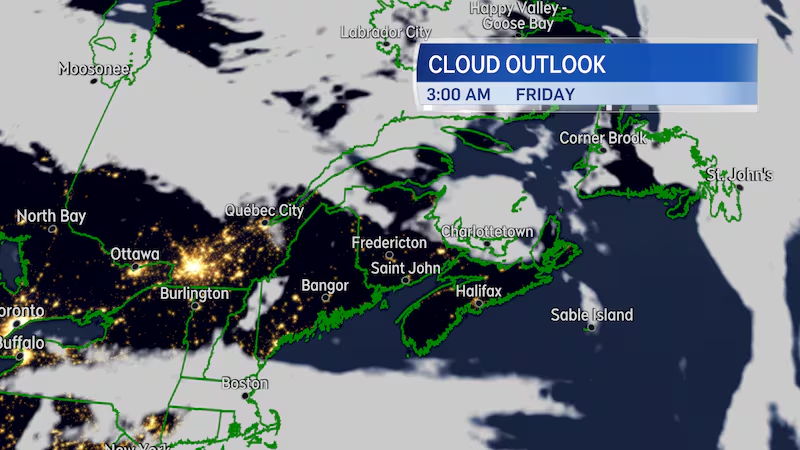
There will be a mix of sun and cloud on Tuesday, with the cloudier conditions mostly expected in New Brunswick where there is also a low chance of flurries and showers. Wednesday starts cloudy with a chance of showers but is expected to clear to sunny breaks for the afternoon. High pressure is forecast to be centred over the region on Thursday and there should be a good amount of sun on that day as a result. The high pressure starts to shift east of the Maritimes on Friday but that day is likely to be mostly sunny as well.
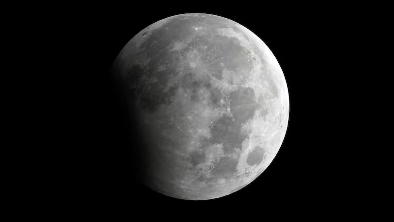
The late week high pressure could work in our favour for viewing of the lunar eclipse Thursday night into Friday morning. The moon will begin to enter the Earth’s umbra (darkest part of the Earth’s shadow) at about 2:10 a.m. Friday morning (Atlantic Time is currently three hours behind UTC). The moon will be completely eclipsed by the Earth’s umbra by 3:25 a.m. The moon will remain eclipsed by the umbra until about 4:30 a.m.
Remember that a lunar eclipse isn’t a complete blackening out of the moon. Instead it gives the moon a brown-reddish hue. It’s sometimes referred to as a Blood Moon.
High pressure works to prevent the upward motion in the atmosphere that is needed to develop clouds and precipitation. It’s the type of weather system we want to have in place if we are looking for decent night sky viewing conditions.
Weekend outlook
As the late week high pressure moves to our east, the Maritimes will be put into the area between that weather system and a developing low moving across Northern Ontario.
Between the two systems, there will be a steady southerly wind that is projected to move the region towards slightly milder March temperatures on the weekend.
Now the weather fronts associated with the low moving through Ontario are expected to eventually reach the Maritimes. As they do so they will increase cloudiness and brings in a round of wet weather. Late Sunday into Monday likely to see rain and showers develop and move into the Maritimes.