A northwest wind will keep Maritimers shivering through another very cold February night. A Colorado low brings a mix of snow and rain in late Thursday into early Friday morning.
Cold Wednesday night, Thursday morning
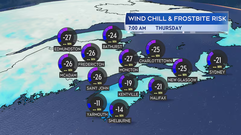
A deep winter cold is in place across the Maritimes on Wednesday. Afternoon temperatures held mostly in a range of -8 C to -14 C. Most communities feel into the minus-20s with the wind chill.
While not a record setting day for cold for a Feb. 5, it is several degrees below average temperatures for early February.
A frigid night is ahead with low temperatures falling into a range of -18 C to -22 C for much of New Brunswick, -14 C to -19 C for much of Nova Scotia, and -17 C to -21 C for Prince Edward Island.
While the gusty wind eases a bit Wednesday night, the Maritimes should mostly expect to start Thursday morning with a wind chill still making it feel well into the minus-20s.
Colorado low brings mix of rain, snow
A low-pressure system that developed on the eastern side of the Rockies in the U.S. will progress eastward across the U.S. Midwest and into Ontario on Thursday.
The system will trigger the development of a second area of low pressure that will move up from Cape Cod and into New Brunswick Thursday night.
Snow will develop west-to-east across the Maritimes late Thursday afternoon through evening. The snow clears the region before sunrise Friday but is followed by some scattered flurries on that day.
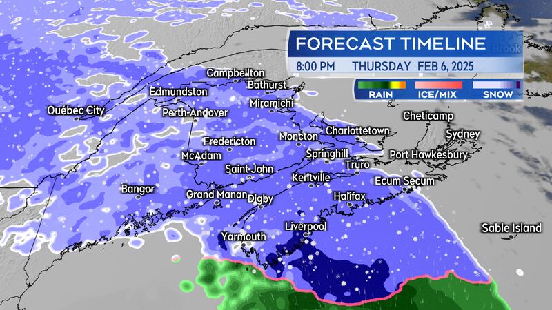
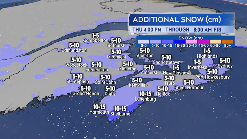
A snowfall of five-to-10 centimetres is expected for much of the Maritimes, some localized totals of 10-to-15 centimetres are possible. The snow turns to a brief period of rain for southern New Brunswick, Nova Scotia, and Prince Edward Island before clearing. Expect that there will be some snow covered or slushy road conditions present both Thursday night and Friday morning.
The snow will be accompanied by a gusty southerly wind becoming westerly. Peak gusts of 30-to-60 km/h for the Maritimes except near 70 km/h on exposed areas of the coastline and higher terrain. Gusts will exceed 100 km/h for northern Inverness County, Cape Breton Thursday overnight and early Friday morning due to the topography of the Highlands.
Sunday holds potential for snow
A second low-pressure system moving through the U.S. is forecast to exit New England and pass south and east of Nova Scotia Sunday.
That next system has the potential to be the snowier of the two for parts of the Maritimes. Based on the expected path of the low, southwestern New Brunswick and parts of mainland Nova Scotia would have the highest chance of a snowfall reaching and exceeding 15 cm.
I expect to have more confidence in a range of snowfall for Sunday and where the heaviest may fall by Friday. Updates here and the CTV News Atlantic 5, 6, and 11:30 p.m. programs.


