A coastal low-pressure system brought a heavy snowfall to parts of the Maritimes Sunday night into Monday morning. Arctic sourced air that has been plunging across a large part of the country begins to filter into the Maritimes in a northwest wind. The coldest stretch of winter weather so far is ahead this week.
Rain and snow reports
The first low-pressure system that moved through Saturday night into Sunday morning brought a widespread 10-to-25 mm of rain.
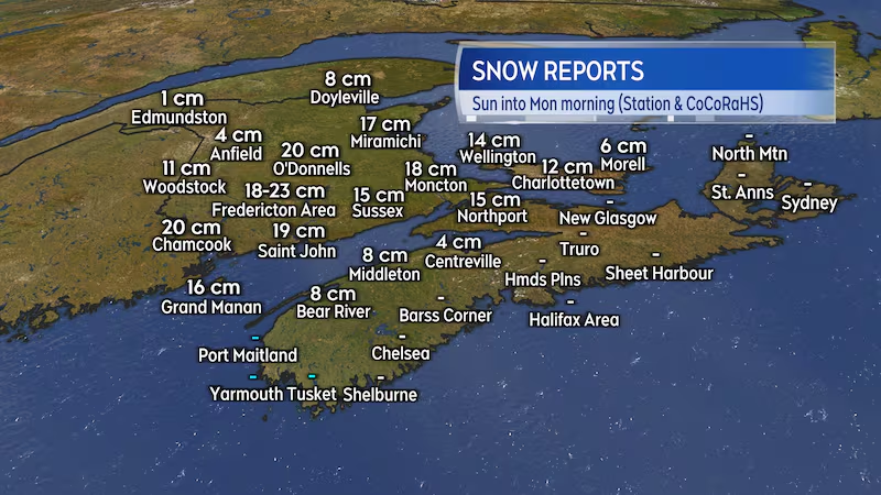
The second low-pressure system landed with heavier snow for parts of the region Sunday night into Monday morning. Central and southern parts of New Brunswick received a widespread 15-to-25 cm of snow. Cumberland County, N.S., picked up 10-to-20 cm of snow, as did western areas of Prince Edward Island. Several centimetres of snow were reported in parts of the Annapolis Valley, N.S.
The remaining snow with the system will continue to slowly taper off Monday afternoon into Monday evening. Some places can expect an addition one-to-five centimetres of snow.
Temperatures will fall Monday afternoon into evening. Watch for any slushy or wet surfaces to turn icy through Monday evening.
Bitter cold triggers weather warning
A breakdown of the polar vortex has allowed for Arctic sourced air to move down into much of the country. This typically happens at least a few times during any given winter season. These types of Arctic outbreaks are typically responsible for the coldest stretches of winter.
As of Monday afternoon, Extreme Cold warnings extend from eastern Alberta across Saskatchewan, Manitoba, Ontario, Quebec and into northwestern New Brunswick. The warning for northwestern New Brunswick called for a period of wind chill, making it feel -35 C to -40 C early Tuesday morning. Wind chill values will make it feel like -35 C or colder and come with a risk of frostbite to exposed skin in 20 minutes or less. The criteria for an Extreme Cold warning to be issued in the Maritimes is an expected period of at least two hours of temperature -35 C or colder or wind chill making it feel -35 C or colder.
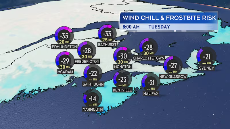
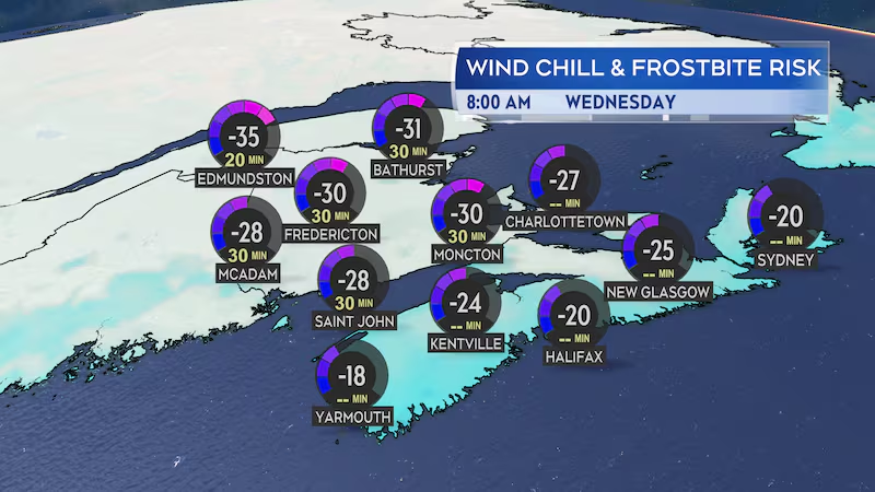
Much of the Maritimes can expect to start Tuesday morning with a wind chill making it feel into the minus 20s and 30s. The wind chill will ease slightly through the day. Similar wind chill values are then expected to return Tuesday night into Wednesday morning.
Dressing in layers with the outermost layer being wind resistant is recommended.
How long the cold snap will last
The coldest temperature for this week are expected Tuesday through Friday. The temperatures are then expected to moderate by a few degrees for next weekend. For much of the Maritimes this will be coldest stretch of winter so far.
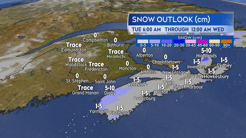
A round of snow on Tuesday for Nova Scotia is expected to bring amounts of one-to-five centimetres. There will be localized totals of five-to-10 centimetres for Yarmouth and Digby counties. It will start in the southwest of the province by the afternoon, reaching eastern areas by evening.
A low-pressure system passing to the east of Nova Scotia on Wednesday is expected to hold the snow associated with it offshore.