Another 'bomb cyclone' bears down on Vancouver Island
 The storm will be another bomb cyclone but stronger than the one we just dealt with on Thursday. (CTV News)
Victoria -
Are you ready for another “Big Blow?"
To help you with your answer we have to travel back to Oct. 12, 1962. That date has been referenced a lot this past week on social media as we prepare for a possible record-breaking low-pressure system for the Pacific Northwest.
The Big Blow, or as it’s known to our American friends, the Columbus Day Storm of 1962, was originally Typhoon Freda. When it hit the West Coast it had a massive impact.
The storm was one of the most powerful extratropical cyclones ever recorded. The winds associated with this storm were in excess of 230 km/h at its peak.
While the storm did weaken as it moved north into British Columbia, the peak wind gusts were still 140 km/h, caused $80 million dollars in damage and killed five people.
The lowest pressure recorded during the Big Blow was 960-958 hPa or millibars of pressure. The storm we’re waiting for on Sunday could potentially have pressure as low as 944 hPa, according to some models.
It will be another bomb cyclone but stronger than the one we just dealt with on Thursday.
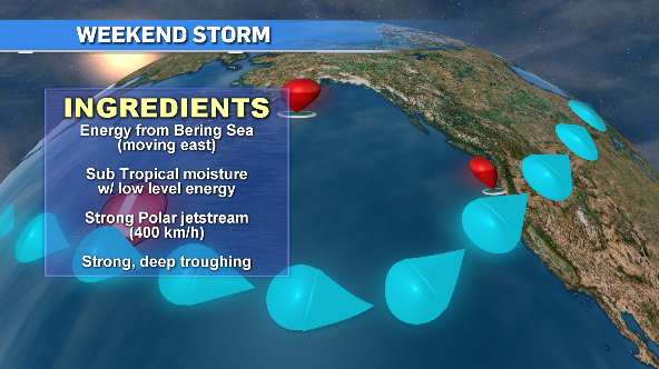
There are a few factors helping to make this system a monster. We’re being fed lots of energy from the Bering Sea, which is typical.
The huge amount of subtropical moisture and a fast moving polar jetstream, rolling at approximately 400 km/h, along with some strong troughing near Vancouver Island are all combining to make this a possible record-breaking bomb cyclone.
The problem this system is currently presents is not only how low that pressure will go but the path of where this storm is heading.
As the storm hits land, it will weaken but the location of the most intense features are still up in the air, literally.
There’s a good chance it moves in south of Vancouver Island and impacts Washington state more than us but we could also see a shift north where the west coast and northern areas of the island are the most impacted.
Sunday though Monday morning will be the timeframe we’re dealing with this next big storm. We still have to wait it out when it comes to the finer details as things change quickly.
No matter where it lands, wind will be the biggest factor with rain being less of a concern.
Don’t get me wrong, a good amount of rain will fall but here on the island our numbers won’t match what they’ll see in Northern California, with a possible 300 millimetres hitting the area, which in turn could create massive flooding and mudslides.
Rainfall numbers through the weekend are in the 50- to 100-millimetre range on Vancouver Island and if we take Thursday’s storm as a template, wind gusts will hit the triple digits in a few areas.
The west coast and northern areas will receive the stronger gusts. Expect huge waves on the coast as well. Those will start to swell early Sunday.
While we won’t see the destruction of the Big Blow, we still need to brace ourselves for an intense weekend of angry weather. It’s always best with these situations to prepare for the worst and hope for the best.


CTVNews.ca Top Stories

Cuban government apologizes to Montreal-area family after delivering wrong body
Cuba's foreign affairs minister has apologized to a Montreal-area family after they were sent the wrong body following the death of a loved one.
What is changing about Canada's capital gains tax and how does it impact me?
The federal government's proposed change to capital gains taxation is expected to increase taxes on investments and mainly affect wealthy Canadians and businesses. Here's what you need to know about the move.
Quebec nurse had to clean up after husband's death in Montreal hospital
On a night she should have been mourning, a nurse from Quebec's Laurentians region says she was forced to clean up her husband after he died at a hospital in Montreal.
'Anything to win': Trudeau says as Poilievre defends meeting protesters
Prime Minister Justin Trudeau is accusing Conservative Leader Pierre Poilievre of welcoming 'the support of conspiracy theorists and extremists,' after the Conservative leader was photographed meeting with protesters, which his office has defended.
Fair in Ontario, flurries in Labrador: Weather systems make for an erratic spring
"It's a bit of a complicated pattern; we've got a lot going on," said Jennifer Smith of the Meteorological Service of Canada in an interview with CTVNews.ca on Wednesday. "[As is] typical with weather, all of these things are related."
Police tangle with students in Texas and California as wave of campus protest against Gaza war grows
Police tangled with student demonstrators in Texas and California while new encampments sprouted Wednesday at Harvard and other colleges as school leaders sought ways to defuse a growing wave of pro-Palestinian protests.
Bank of Canada officials split on when to start cutting interest rates
Members of the Bank of Canada's governing council were split on how long the central bank should wait before it starts cutting interest rates when they met earlier this month.
Northern Ont. lawyer who abandoned clients in child protection cases disbarred
A North Bay, Ont., lawyer who abandoned 15 clients – many of them child protection cases – has lost his licence to practise law.
'My stomach dropped': Winnipeg man speaks out after being criminally harassed following single online date
A Winnipeg man said a single date gone wrong led to years of criminal harassment, false arrests, stress and depression.
Shopping Trends
The Shopping Trends team is independent of the journalists at CTV News. We may earn a commission when you use our links to shop. Read about us.


Vancouver
-

'It was instant karma': Viral video captures failed theft attempt in Nanaimo, B.C.
Mounties in Nanaimo, B.C., say two late-night revellers are lucky their allegedly drunken antics weren't reported to police after security cameras captured the men trying to steal a heavy sign from a downtown business.
-
RCMP officers 'refused' to provide evidence to Crown to assist drug, firearms prosecution: report
Crown counsel was unable to approve "significant" drug and weapons charges stemming from an arrest in Quesnel, B.C., last year because the officers involved "refused to provide any evidence," according to a report from the province’s police watchdog.
-
No injuries after 'targeted shooting' at Abbotsford home, police say
Shots were fired into a basement suite in Abbotsford earlier this week, according to authorities.
Kelowna
-

B.C. man rescues starving dachshund trapped in carrier: BC SPCA
An emaciated dachshund is now recovering thanks to a Good Samaritan who found the pup near a biking trail in Kelowna, according to the BC SPCA.
-
Search crews called in after missing Kelowna senior's truck found
Search and rescue crews have been called in after a vehicle belonging to a missing senior was located near a rural intersection outside of Kelowna Tuesday.
-
Homicide investigation underway after body found near Kelowna, B.C.
Major crime detectives in British Columbia are investigating a suspected homicide after a body was found in a remote area southeast Kelowna over the weekend.
Edmonton
-

Nurse practitioners to make 80% as much as family doctors for publicly-funded primary care
The Alberta government says it will pay nurse practitioners 80 per cent of what family doctors are paid – if they want to practice comprehensive primary care.
-
Measles case in Edmonton prompts exposure warning
Alberta Health Services issued a measles alert in Edmonton Wednesday after confirming a case.
-
7 surveillance videos linked to extortions of South Asian home builders in Edmonton released
The Edmonton Police Service has released a number of surveillance videos related to a series of extortion cases in the city now dubbed 'Project Gaslight.'
Calgary
-

Auburn Bay community members rally around grieving widow, three young children
Residents of one of southeast Calgary neighbourhoods have raised thousands of dollars to support a family grieving the losses of a father and grandfather.
-
'Disingenuous and misleading': Calgary mayor, province at odds over plan to lower utility bills
Calgary's mayor is sparring with the Government of Alberta over the rollout of new legislation meant to lower utility bills in Calgary.
-
Quest School's new Sunalta campus focuses on high school student learning and an adult transition program
Quest School has expanded to a second campus in Calgary that is an innovative learning hub for high school students and young adults with moderate to severe developmental disabilities.
Lethbridge
-

Lethbridge added 28 physicians over the past year, AHS continues search for more
Lethbridge has added 28 physicians over the past year, according to a quarterly report published by the College of Physicians and Surgeons of Alberta.
-
Alberta, B.C. preparing for early start to wildfire season
Wildfires in Alberta and B.C. appear to be getting off to an early start this year. Both province's wildfire services are doing what they can to prepare for what's expected to be a tough summer.
-
Man sent to hospital with head injury following Lethbridge encampment assault
An assault over property at a Lethbridge encampment ended with a man in hospital suffering from a serious head injury.
Winnipeg
-

Manitoba lifts ban on homegrown cannabis, pauses some new retail licences
The Manitoba government is lifting its ban on homegrown recreational cannabis while at the same time pausing approval of some new retail outlets.
-
'I just wanted to stand out': Winnipeg Jets fan goes viral for wearing salmon shirt at Whiteout
A Winnipeg Jets fan found a unique way to stand out amid the Winnipeg Whiteout; he wore a salmon-coloured shirt.
-
Child dies following collision with trailer: Brandon police
A four-year-old child has died following a collision with a trailer in Brandon, Man.
Regina
-

'Learn to walk again': Sask. doctor tells story of miracle recovery from deadly heart condition
It was a powerful morning at Regina's Conexus Arts Centre Wednesday, where the Lieutenant Governor hosted the annual Saskatchewan Prayer Breakfast and a provincial doctor told his story of survival from a deadly heart condition.
-
Throwing star, crossbow found during Sask. RCMP searches at George Gordon FN, Punnichy
A throwing star and crossbow were among the seizures by police as part of a drug trafficking investigation on George Gordon First Nation and in Punnichy, Sask. last week.
-
Sask. police caught 454 impaired drivers in March: SGI
Saskatchewan police caught 454 impaired drivers around the province in March. Of those, 142 are facing Criminal Code charges and the other 312 faced licence suspensions, according to a news release from Saskatchewan Government Insurance (SGI).
Saskatoon
-

Sask. woman helping fill bellies and hearts with free grocery store
Darlene Hartshorn is a mother and grandmother from Warman who is making a difference by helping those who need a hand up.
-
Sask. post secondary receives $17 Million to expand aviation program
Boeing, an international aircraft company, has made a multi-million dollar commitment to the Saskatchewan Indian Institute of Technology (SIIT) to help address shortages in the aviation industry.
-
Sask. woman fights to find out who had her apprehended for a psych. assessment
A Saskatchewan woman who was taken for an involuntary mental health assessment is entitled to find out who had her committed, a provincial court judge has ruled.
Toronto
-

Speed limits to increase on some sections of Ontario highways, province says
The Ontario government says it will be raising the speed limit along certain stretches of provincial highways soon, including Highway 401 and Highway 403.
-
Driver dead after vehicle collides with parked trailer in Mississauga
Peel police are investigating a collision in Mississauga that left one person dead Wednesday afternoon.
-
Toronto police release videos of suspect who allegedly bumped into stranger, stabbed them
Toronto police have released videos of a suspect who allegedly stabbed a stranger he bumped into in the city’s Mount Dennis neighbourhood earlier this week.
Montreal
-

Quebec nurse had to clean up after husband's death in Montreal hospital
On a night she should have been mourning, a nurse from Quebec's Laurentians region says she was forced to clean up her husband after he died at a hospital in Montreal.
-
REM delayed: Stations in West Island, North Shore now opening in 2025
Officials for Montreal's REM line confirmed that the lines to the West Island and the North Shore are being delayed and won't open until 2025.
-
Cuban government apologizes to Montreal-area family after delivering wrong body
Cuba's foreign affairs minister has apologized to a Montreal-area family after they were sent the wrong body following the death of a loved one.
Ottawa
-

NCC buys golf course near Gatineau Park for $3.9 million
The National Capital Commission has purchased the old Dunnderosa Golf Course in Chelsea, Que., as part of its plan to acquire private properties in Gatineau Park.
-
Can cars and bikes fit on the Queen Elizabeth Driveway and Colonel By Drive?
There are questions about how the National Capital Commission might fit bike lanes on the Queen Elizabeth Driveway and Colonel By Drive.
-
Eastern Ont. knitters make 80 peacekeeper 'Izzy Dolls' for D-Day anniversary
Volunteers in Perth, Ont. have knit small peacekeeper "Izzy Dolls" that will be sent to France in commemoration of the 80th anniversary of D-Day and the Battle of Normandy.
Atlantic
-

A community in mourning: 16-year-old killed at Halifax parkade remembered
Community members gathered at a mosque for Ahmad Al Marrach — a 16-year-old murder victim — for his funeral on Wednesday.
-
N.S. man wins $1.5M through Atlantic Lottery
A Cape Breton man won $1.5 million after buying $200-worth of Atlantic Lottery Scratch’N Win tickets.
-
'Life was not fair to him': Daughter of N.B. man exonerated of murder remembers him as a kind soul
The daughter of a New Brunswick man recently exonerated from murder, is remembering her father as somebody who, despite a wrongful conviction, never became bitter or angry.
London
-

'I think 110 is fast enough': Speed limit to increase on some sections of 400 series highways
The speed you travel on sections of 400 series highways in our region is increasing. The province says it will raise the speed limit to 110 km/h on multiple sections, including some in the London region.
-
Nuclear waste referendum date set for October
Residents in the Municipality of South Bruce will decide whether they want to host Canada’s first permanent nuclear waste storage facility this October.
-
How do U.S. decisions about TikTok impact Canada?
U.S. President Joe Biden has signed a bill that will force TikTok to be sold or be banned in his country, but what does it mean for Canada?
Kitchener
-

Ont. teacher says she's being forced to switch pharmacies to maintain medication coverage
A Waterloo, Ont. teacher says she’s frustrated after learning the arthritis medication she depends on is no longer covered under her benefits plan and she'll have to switch pharmacies to avoid paying out of pocket.
-
Film crew transforms Cambridge pizza shop
A Cambridge pizza restaurant got a temporary makeover this week, turning into a fictitious donut shop as part of a film production.
-
Pedestrian seriously hurt after crash in Kitchener
A pedestrian had to be taken to an out-of-region hospital following a crash in Kitchener.
Northern Ontario
-

Northern Ont. lawyer who abandoned clients in child protection cases disbarred
A North Bay, Ont., lawyer who abandoned 15 clients – many of them child protection cases – has lost his licence to practise law.
-
Garden River chief meets with disgruntled band members over payout concerns
Some members of the Garden River First Nation are demanding answers regarding the disbursement of the Robinson-Huron Treaty settlement funds.
-
'My stomach dropped': Winnipeg man speaks out after being criminally harassed following single online date
A Winnipeg man said a single date gone wrong led to years of criminal harassment, false arrests, stress and depression.
N.L.
-

Rideshare platform Uber expands to Newfoundland and Labrador
Uber Technologies Inc. says it has brought its ridesharing platform to Newfoundland and Labrador.
-
Newfoundland director found creeping terror of 'The King Tide' in a tiny coastal town
Newfoundlander Christian Sparkes has shot several films around his home province, but with his new psychological thriller 'The King Tide' he saw an opportunity to wander into one unique town that had eluded him over the years.
-
2 people dead, 4 others make it to shore after vessel capsizes in Newfoundland
The Department of Fisheries and Oceans says two people were found dead and four others survived after a boat capsized off the west coast of Newfoundland.