Another 'bomb cyclone' bears down on Vancouver Island
 The storm will be another bomb cyclone but stronger than the one we just dealt with on Thursday. (CTV News)
Victoria -
Are you ready for another “Big Blow?"
To help you with your answer we have to travel back to Oct. 12, 1962. That date has been referenced a lot this past week on social media as we prepare for a possible record-breaking low-pressure system for the Pacific Northwest.
The Big Blow, or as it’s known to our American friends, the Columbus Day Storm of 1962, was originally Typhoon Freda. When it hit the West Coast it had a massive impact.
The storm was one of the most powerful extratropical cyclones ever recorded. The winds associated with this storm were in excess of 230 km/h at its peak.
While the storm did weaken as it moved north into British Columbia, the peak wind gusts were still 140 km/h, caused $80 million dollars in damage and killed five people.
The lowest pressure recorded during the Big Blow was 960-958 hPa or millibars of pressure. The storm we’re waiting for on Sunday could potentially have pressure as low as 944 hPa, according to some models.
It will be another bomb cyclone but stronger than the one we just dealt with on Thursday.
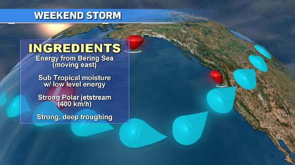
There are a few factors helping to make this system a monster. We’re being fed lots of energy from the Bering Sea, which is typical.
The huge amount of subtropical moisture and a fast moving polar jetstream, rolling at approximately 400 km/h, along with some strong troughing near Vancouver Island are all combining to make this a possible record-breaking bomb cyclone.
The problem this system is currently presents is not only how low that pressure will go but the path of where this storm is heading.
As the storm hits land, it will weaken but the location of the most intense features are still up in the air, literally.
There’s a good chance it moves in south of Vancouver Island and impacts Washington state more than us but we could also see a shift north where the west coast and northern areas of the island are the most impacted.
Sunday though Monday morning will be the timeframe we’re dealing with this next big storm. We still have to wait it out when it comes to the finer details as things change quickly.
No matter where it lands, wind will be the biggest factor with rain being less of a concern.
Don’t get me wrong, a good amount of rain will fall but here on the island our numbers won’t match what they’ll see in Northern California, with a possible 300 millimetres hitting the area, which in turn could create massive flooding and mudslides.
Rainfall numbers through the weekend are in the 50- to 100-millimetre range on Vancouver Island and if we take Thursday’s storm as a template, wind gusts will hit the triple digits in a few areas.
The west coast and northern areas will receive the stronger gusts. Expect huge waves on the coast as well. Those will start to swell early Sunday.
While we won’t see the destruction of the Big Blow, we still need to brace ourselves for an intense weekend of angry weather. It’s always best with these situations to prepare for the worst and hope for the best.


CTVNews.ca Top Stories

NEW
NEW After hearing thousands of last words, this hospital chaplain has advice for the living
Hospital chaplain J.S. Park opens up about death, grief and hearing thousands of last words, and shares his advice for the living.
Police cordon off Iran consulate in Paris where man threatens to blow himself up: French media
French police cordoned off the Iranian consulate in Paris on Friday, where a man was threatening to blow himself up, Europe 1 radio and BFM TV.
Families to receive Canada Child Benefit payment on Friday
More money will land in the pockets of some Canadian families on Friday for the latest Canada Child Benefit installment.
BREAKING
BREAKING Iran fires at apparent Israeli attack drones near Isfahan air base and nuclear site
An apparent Israeli drone attack on Iran saw troops fire air defences at a major air base and a nuclear site early Friday morning near the central city of Isfahan, an assault coming in retaliation for Tehran's unprecedented drone-and-missile assault on the country.
American millionaire Jonathan Lehrer denied bail after being charged with killing Canadian couple
American millionaire Jonathan Lehrer, one of two men charged in the killings of a Canadian couple in Dominica, has been denied bail.
Ottawa to force banks to call carbon rebate a carbon rebate in direct deposits
Canadian banks that refuse to identify the carbon rebate by name when doing direct deposits are forcing the government to change the law to make them do it, says Environment Minister Steven Guilbeault.
'It was all my savings': Ontario woman loses $15K to fake Walmart job scam
A woman who recently moved to Canada from India was searching for a job when she got caught in an online job scam and lost $15,000.
After COVID, WHO defines disease spread 'through air'
The World Health Organization and around 500 experts have agreed for the first time on what it means for a disease to spread through the air, in a bid to avoid the confusion early in the COVID-19 pandemic that some scientists have said cost lives.
Prince Harry formally confirms he is now a U.S. resident
Prince Harry, the son of King Charles III and fifth in line to the British throne, has formally confirmed he is now a U.S. resident.
Shopping Trends
The Shopping Trends team is independent of the journalists at CTV News. We may earn a commission when you use our links to shop. Read about us.


Vancouver
-

Facebook Marketplace seller must refund buyer over false advertising, B.C. tribunal decides
A Facebook Marketplace seller is being ordered by B.C.'s small claims tribunal to repay hundreds of dollars after selling a product under false advertising.
-
Bigger boats, more nets, people arrive in Zeballos, B.C., for new orca rescue attempt
A large seine fishing vessel capable of casting a net strong enough to hold a nearly 700-kilogram killer whale calf has arrived in Zeballos, B.C., to participate in the latest attempt to rescue the young orca stranded in a remote tidal lagoon.
-
B.C. premier defends drug decriminalization as controversy grows, feds scrutinize program
The premier of British Columbia is continuing to defend the three-year pilot program underway in his province that’s decriminalized personal possession of hard drugs, even as the federal government sends its minister responsible to discuss growing concerns and controversies.
Kelowna
-

Stolen snake named Milkshake returned to Kelowna pet store
A banana ball python that was stolen from a Kelowna pet store on Saturday has been returned unharmed, Mounties said.
-
Nurses rally at B.C. Interior hospital over security, staffing concerns
Nurses held a rally Wednesday at a hospital in the B.C. Interior that closed its emergency department more than a dozen times last year due to insufficient staff.
-
B.C. to add 240 complex-care housing units throughout province
British Columbia is planning to add 240 new units to its complex-care housing program, providing homes for people with mental-health and addictions challenges that overlap with other serious conditions.
Edmonton
-

MacKinnon has 2 assists, breaks franchise's single-season points mark as Avs beat Oilers 5-1
Valeri Nichushkin scored twice, Nathan MacKinnon added two assists to break the franchise’s single-season points mark and the Colorado Avalanche cruised into the playoffs behind a 5-1 win over the Edmonton Oilers on Thursday night.
-
New study explores visitor experiences in Alberta dark sky preserves
The health and environmental benefits of protecting a region from light pollution are already well established, and one only has to look at the stream of visitors to the Jasper Dark Sky Festival or the Alberta's newest dark sky preserve in Lakeland Provincial Park to get a sense of how "astrotourism" can boost rural economies.
-
Families to receive Canada Child Benefit payment on Friday
More money will land in the pockets of some Canadian families on Friday for the latest Canada Child Benefit installment.
Calgary
-

Calgary mayor to comment on controversial rezoning plan
Mayor Jyoti Gondek is expected to share her thoughts on Calgary's rezoning plan – one of the most contentious issues to face the city in recent years.
-
'One of the brightest little girls I know': Family of Calgary toddler killed in 2022 speaks out
Calgary police say Winston Campbell, 45, has been charged in the death of a two-year-old girl in 2022.
-
Bats are returning to Alberta or waking up - make them welcome
Spring migration usually brings up images of songbirds sweetly singing in yards, or waves of ducks following the melting snow north.
Lethbridge
-

Deterrent sentence possible, expert says, after trio convicted in connection to Coutts border blockade
Three men who helped lead and co-ordinate the 2022 border blockade at Coutts, Alta., have been found guilty of public mischief.
-
Central Alberta man arrested in connection with grandparent scam
Lethbridge police have arrested a Vermilion, Alta., man in connection with a 'grandparent scam' that took aim at a local senior.
-
Woman, 61, killed in crash north of Coaldale, Alta.: RCMP
An Alberta woman was killed in a multi-vehicle crash on a highway north of Coaldale, Alta., on Wednesday morning.
Winnipeg
-

WINSAR members ready to answer the call for missing persons
In southern Manitoba, members of Winnipeg Search and Rescue (WINSAR) remain vigilant as they assist in finding a missing Manitoban.
-
'It could be catastrophic': Woman says natural supplement contained hidden pain killer drug
A Manitoba woman thought she found a miracle natural supplement, but said a hidden ingredient wreaked havoc on her health.
-
'This is an eyesore': City charting plan to clean giant debris left for two years on Sherbrook Street
The City of Winnipeg is finally moving ahead with a plan to clear away a large pile of debris on a private lot.
Regina
-

'Poor choice of words': Education Minister apologizes for remarks made to Sask. mother
On Thursday, Education Minister Jeremy Cockrill apologized for remarks he made to a mother who had advocated for better classroom supports earlier this week.
-
Sask. dental providers and seniors raise concerns over federal dental care plan
With the Canadian Dental Care Plan (CDCP) set to roll out on May 1, many dental care providers have concerns and unanswered questions about the plan.
-
'Bad taste in your mouth': Regina man mistakenly told he won $50K boat through Roll up the Rim
Chris Ross was pleasantly surprised when Tim Hortons sent him an email summarizing his "Roll up the Rim" winnings for the season. The email claimed Ross had won a boat valued at over $50,000 – but it was a mistake.
Saskatoon
-

Final offer or tentative agreement? Teachers, province differ on what latest deal means
Saskatchewan Teachers' Federation (STF) President Samantha Becotte says two days of "difficult" negotiations has led to a "final offer" with slight improvements to salary and the inclusion of a line in the collective agreement – promising to address classroom complexity issues.
-
Saskatoon police committing three officers to curb crime in Pleasant Hill
The Saskatoon Police Service (SPS) is dedicating three officers to a specialized unit to help curb crime in the Pleasant Hill neighbourhood.
-
Sask. village, contractor fined $42,000 for illegal dumping
A Saskatchewan village and a contractor it hired are facing significant fines after conservation officers discovered they dumped demolition waste at an illegal landfill.
Toronto
-

'It was all my savings': Ontario woman loses $15K to fake Walmart job scam
A woman who recently moved to Canada from India was searching for a job when she got caught in an online job scam and lost $15,000.
-
Families to receive Canada Child Benefit payment on Friday
More money will land in the pockets of some Canadian families on Friday for the latest Canada Child Benefit installment.
-
'He left a mark in this world': Toronto teen who drowned in Lake Ontario remembered
He was a loving son and brother, a loyal and kind friend, and a dedicated volunteer in Toronto’s east end, say those who knew and loved Mohammad Khasim.
Montreal
-

American millionaire Jonathan Lehrer denied bail after being charged with killing Canadian couple
American millionaire Jonathan Lehrer, one of two men charged in the killings of a Canadian couple in Dominica, has been denied bail.
-
Here are the Montreal road closures planned for the weekend
Those driving in and around Montreal on the weekend should be aware that construction work will result in some major route closures.
-
Quebec judge suspends parts of Bill 96 that apply to English school boards
The English Montreal School Board (EMSB) is celebrating what it calls a 'significant win' in court after a judge stayed parts of Quebec's language laws that apply to English school boards across the province.
Ottawa
-

OPP reminds drone operators it's illegal to operate a drone near emergency sites following Hwy. 417 fatal crash
Ontario Provincial Police are reminding people that it is illegal to fly a drone over traffic collision sites, after drone footage captured over a fatal crash on Hwy. 417 in Ottawa appeared online.
-
5 vehicles a day reported stolen in Ottawa so far in 2024, statistics show
Statistics available on the Ottawa Police Service's crime map shows there have been 560 vehicle thefts reported across Ottawa since Jan. 1. Police reported 504 vehicles stolen in the first six months of 2023, and 387 vehicle thefts between Jan. 1 and June 30, 2022.
-
Two people accused of selling fake gold jewelry at Hwy. 401 service station in eastern Ontario
Two Scarborough, Ont. residents are facing charges after Ontario Provincial Police received a complaint about the sale of fake gold jewelry at a service station on Hwy. 401 in eastern Ontario.
Atlantic
-

'Dangerous man' with firearm in Bible Hill in custody: N.S. RCMP
The RCMP says a 'dangerous man' with a firearm in Bible Hill, N.S., is in custody Friday morning.
-
Ottawa to force banks to call carbon rebate a carbon rebate in direct deposits
Canadian banks that refuse to identify the carbon rebate by name when doing direct deposits are forcing the government to change the law to make them do it, says Environment Minister Steven Guilbeault.
-
N.S. justice minister apologizes for domestic violence comments
Nova Scotia's opposition parties are calling for the justice minister to resign after he said domestic violence is not an "epidemic."
London
-

Crash causes power outage in St. Thomas
According to police, there was “significant damage” to the hydro pole, causing a power outage to the surrounding areas.
-
Man arrested after police locate stolen vehicle
A Lucan man is facing a number of charges after police said they recovered a stolen truck.
-
Witness alleges years of severe abuse at the hands of parents
A jury heard some horrific evidence Thursday at the trial of a London, Ont. couple charged with physically and sexually abusing their children.
Kitchener
-

Landlords reporting increase in tenants refusing to pay rent or leave
A property management company in Fergus is still cleaning up after they say a tenant trashed one of their units and refused to pay rent -- and they say it's not the only similar case they've dealt with recently.
-
Gas price hike blamed on change in seasons, motorists 'shocked'
Gas prices across Ontario have spiked to levels not seen in nearly two years as the switch from winter fuel to a more expensive summer blend pushes the price at the pumps.
-
What are these things doing in Waterloo Park?
Don’t be alarmed if you see some strange new creatures in Waterloo Park.
Northern Ontario
-
Fatal crash at northern Ont. business on Highway 17
One person has died as the result of a single-vehicle crash at a northern Ontario business on Highway 17 on Thursday afternoon, police say.
-
Families to receive Canada Child Benefit payment on Friday
More money will land in the pockets of some Canadian families on Friday for the latest Canada Child Benefit installment.
-
'It was all my savings': Ontario woman loses $15K to fake Walmart job scam
A woman who recently moved to Canada from India was searching for a job when she got caught in an online job scam and lost $15,000.
N.L.
-

N.L. gardening store revives 19th century seed-packing machine
Technology from the 19th century has been brought out of retirement at a Newfoundland gardening store, as staff look for all the help they can get to fill orders during a busy season.
-
500 Newfoundlanders wound up on the same cruise and it turned into a rocking kitchen party
A Celebrity Apex cruise to the Caribbean this month turned into a rocking Newfoundland kitchen party when hundreds of people from Canada's easternmost province happened to be booked on the same ship.
-
Protest averted as Newfoundland and Labrador premier helps reach pricing deal on crab
A pricing agreement has been reached between crab fishers and seafood processors that will allow for Newfoundland and Labrador's annual crab fishery to get started.