
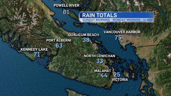
This afternoon’s sunshine is a brief, but welcome, break between systems. Over the weekend winds howled and rains soaked Vancouver Island. Here’s a look at the storm totals, as reported by Environment Canada.
The next system arrives tomorrow, ushering in warm air. Temperatures will approach record levels Tuesday and Wednesday in some parts of the Capital Region as freezing levels rise quickly to about 2,800 meters.
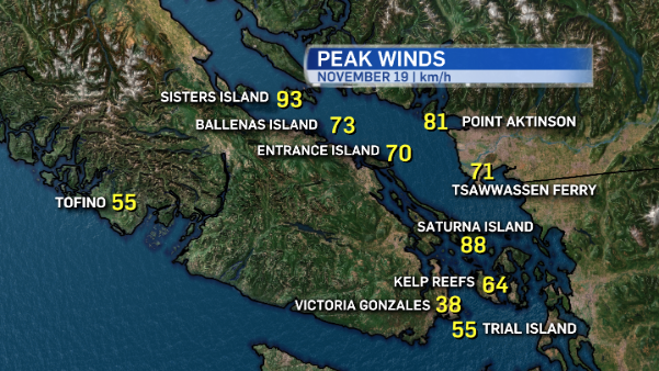
Along with the milder conditions, the warm front bring a fair amount of rain and strong winds. A wind warning is in effect for North Vancouver Island as east to southeast winds near 90 km/h are expected to develop over exposed coastal sections Tuesday.
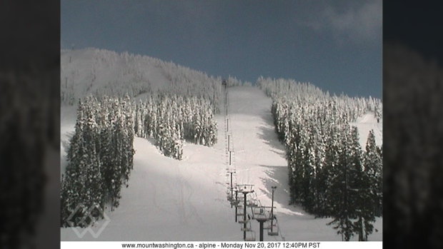
Snow blankets Mt. Washington Alpine Resort ahead of a system that is expected to bring high winds and lots of rain to Vancouver Island mountains. Nov. 20, 2017.
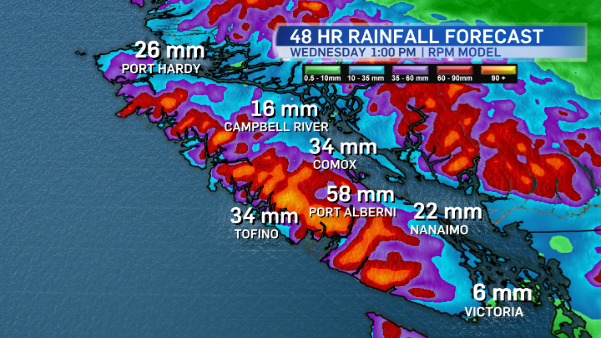
As the warm air mass moves in, winds in the alpine are expected to be around 60km/h at times, with stronger gusts. As for precipitation in the island mountains, rainfall totals could amount to 50-70 millimetres in the 48 hour period following the front’s arrival Tuesday.
At sea level, rain will be heavy at times through many island communities.
The warm airmass remains in place until Thursday when the cold front associated with the system finally sweeps across the island and through the province.
As it crosses over, freezing levels will drop again to about 1500 metres – good news for Mt. Washington! Precipitation associated with the cold front will fall as snow at the alpine resort Thursday. Heavy rain at sea level will fall as snow again at the mountain. Thursday will also be windy at times!
Your Island Winter
I’ve mentioned this a couple of times already, but there’s quite a buzz about winter predictions right now. The island has already experienced a brief cold snap, with snow in some areas. Overarching forecast models and current weather pattern analysis indicated a La Nina pattern is present and there’s a 65 to 75 per cent chance that it’ll conitnue through winter 2017-2018.
What does that mean for us? Get ready for higher amounts of precipitation than average on Vancouver Island, as well as colder than average temperatures through winter. That said, the pros at Environment Canada’s weather office in Vancouver put the seasonal forecasts in perspective:
Something to keep in mind when looking at #SeasonalForecasts: We (and everyone else) have absolutely NO skill in forecasting precipitation beyond 2 weeks #MythBusting pic.twitter.com/1W57tEAhCx
— ECCC Weather BC (@ECCCWeatherBC) November 20, 2017


