
Who’s ready for temperatures to head into the 20s? I am! Sunny, warm weather is just around the corner – mere hours away – we just have to endure a little more rain.
Warm front spreads rain over the island overnight
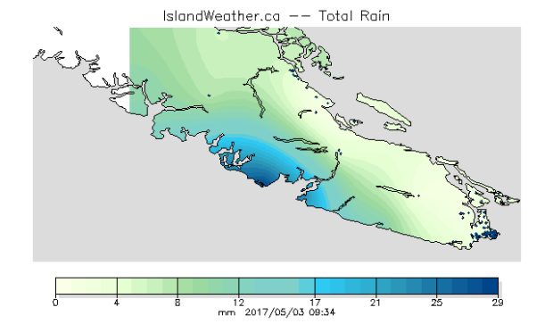
It approached late yesterday and as promised, a warm front delivered. Rain spread over Vancouver Island overnight with the greatest rainfall measured along the west coast. The School Based Weather Station Network shows nearly 30 millimetres of rain since midnight at Ucluelet High School.
This morning we have mist in the Capital Region, drizzle in Nanaimo and light rain with fog near Comox. Warm fronts often produce lighter types and amounts of precipitation, and that’s what we’re seeing this morning.
Sunshine, however, is breaking through in Port Hardy and at Victoria’s Inner Harbour this morning. This is indicative of the kind of day we’ll have today. For the South Island, showers should be wrapped up by noon. Clearing begins from the south today as the front slowly lifts northward throughout the day. North Island communities will have a few breaks in the clouds in between showers before the rain clears later today or tonight.
BBQ Weather Thursday
Behind the front we’re in for clearing skies and warm temperatures. In fact, temperatures Thursday afternoon are expected to be some of the warmest of the year so far! We typically reach our warmest temperatures late in the afternoon, so weather will be perfect for barbecuing tomorrow evening.
The warm push is thanks to a ridge of high pressure that will intensify tomorrow. Temperatures are set to reach the low 20s around Greater Victoria, the mid-20s through inland Vancouver Island including Port Alberni, and the mid-to-high teens along the west coast.
Now – a brief note about this abrupt change in weather, from cool and showery to hot and sunny. Sometimes, a dramatic change like this in such a short amount of time can create sufficient instability to produce thunderstorms. As it stands right now, forecast models suggest the greatest risk of thunderstorms is to the south in Washington State, but there’s a slight chance we could hear some thunder rumbling or get even a brief hail or downpour late Thursday evening and possibly Friday on the island. I’ll keep you posted.
That aside, as is the pattern this spring, the warm sunshine we enjoy Thursday won’t last long.
Unsettled Friday
Friday an upper trough returns spreading light showers over the South Island, but heavier rain towards the North Island.
Back to better weather
By Saturday early morning most of the showery, rainy weather will be over and sunshine will warm the afternoon once again. The good news: it’s going to stick around for a while!
Most of next week is sunny and warm with temperatures above the seasonal average of 15C. Finally!


