
If you're starting to think that we've had more than our share of "chance of thunderstorms" in the forecast this summer, you're right. Statistically thunderstorms are rare for Vancouver Island.
This year, however, we've had a slow start to summer, thanks to a series of cold lows that have slowly worked their way down the coast of British Columbia. Each one has made the air mass unstable along the coast, ushered in unsettled weather and increased our chance of thunderstorms on the island.
Today is another one of those days where the influence of a cold low increases our chances of showers, thunder and lightning, gusty winds and heavy rain, especially in mountainous areas.
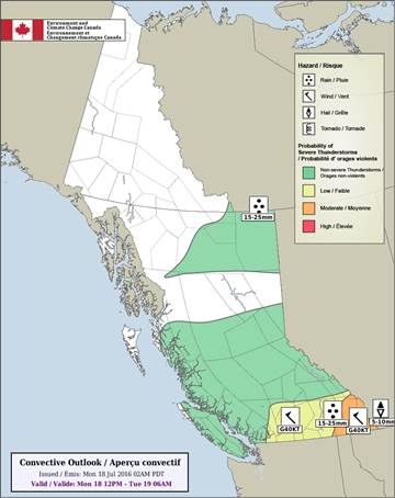
Today's Convective Outlook, as issued by Environment and Climate Change Canada
Looking at the Convective Outlook issued by Environment and Climate Change Canada you can see that most of southern BC has a risk of thunderstorms, but communities in the southeastern corner of the province could see severe thunderstorms develop today, complete with heavy rain, strong winds and hail.
The upper low that is dominating our weather pattern is slow moving. It will continue to bring a risk of showers or thunderstorms to the island overnight.
The unsettled weather lingers through Tuesday and Wednesday thanks to a broad upper trough.
By the end of this week, though, things appear to change. A ridge of high pressure builds bringing warmer temperatures and drier conditions to most of Vancouver Island.


